Lostant, Illinois facts for kids
Quick facts for kids
Lostant, Illinois
|
|
|---|---|
| Etymology: Countess of Lostant, wife of Baron Mercier who visited Illinois in 1861 | |

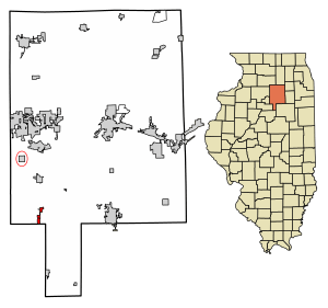
Location in LaSalle County, Illinois
|
|

Location of Illinois in the United States
|
|
| Country | United States |
| State | Illinois |
| County | LaSalle |
| Township | Hope |
| Area | |
| • Total | 1.13 sq mi (2.93 km2) |
| • Land | 1.13 sq mi (2.93 km2) |
| • Water | 0.00 sq mi (0.00 km2) |
| Elevation | 692 ft (211 m) |
| Population
(2020)
|
|
| • Total | 423 |
| • Density | 374.34/sq mi (144.60/km2) |
| Time zone | UTC-6 (CST) |
| • Summer (DST) | UTC-5 (CDT) |
| ZIP code |
61334
|
| Area code(s) | 815 |
| FIPS code | 17-44823 |
| GNIS feature ID | 2399189 |
| Wikimedia Commons | Lostant, Illinois |
Lostant is a small village located in LaSalle County, Illinois, in the United States. It is a part of the larger Ottawa area. In 2020, about 423 people lived there. This was a bit less than the 498 people who lived there in 2010.
Contents
History of Lostant
Lostant got its first post office in 1861. The village was named after Lostant Mercier. She was the wife of a French diplomat named Henri Mercier. He visited Illinois in 1861.
A notable person born in Lostant was Horatio N. Boshell (1872–1933). He was a doctor and later became a state representative for Illinois.
Geography and Location
Lostant is in the southwestern part of LaSalle County. Its southern border reaches the Marshall County line.
How to Get to Lostant
Several roads help people travel to and from Lostant:
- Illinois Route 251 goes through the west side of the village. You can go north about 5 miles (8 km) to Tonica. Or you can go south about 7 miles (11 km) to Wenona.
- Illinois Route 18 crosses the southern part of Lostant. It leads east about 12 miles (19 km) to Streator. To the west, it goes about 16 miles (26 km) to Henry.
- Interstate 39 runs along the southwest edge of the village. You can get on it from Exit 41 (IL 18). I-39 goes north about 15 miles (24 km) to LaSalle. It goes south about 44 miles (71 km) to Normal.
Lostant covers a total area of about 1.13 square miles (2.93 square kilometers). All of this area is land.
Population of Lostant
| Historical population | |||
|---|---|---|---|
| Census | Pop. | %± | |
| 1880 | 363 | — | |
| 1890 | 378 | 4.1% | |
| 1900 | 480 | 27.0% | |
| 1910 | 458 | −4.6% | |
| 1920 | 911 | 98.9% | |
| 1930 | 413 | −54.7% | |
| 1940 | 399 | −3.4% | |
| 1950 | 432 | 8.3% | |
| 1960 | 460 | 6.5% | |
| 1970 | 465 | 1.1% | |
| 1980 | 539 | 15.9% | |
| 1990 | 510 | −5.4% | |
| 2000 | 486 | −4.7% | |
| 2010 | 498 | 2.5% | |
| 2020 | 423 | −15.1% | |
| U.S. Decennial Census | |||
In 2020, Lostant had 423 residents. There were 184 households, and 114 of these were families. The village had about 374 people per square mile (145 per square kilometer).
About 25.7% of the people in Lostant were under 18 years old. Around 15.1% were 65 years or older. The average age in the village was 34.4 years.
School in Lostant
- Lostant Elementary Grade School
See also
 In Spanish: Lostant para niños
 | Frances Mary Albrier |
 | Whitney Young |
 | Muhammad Ali |

