Wenona, Illinois facts for kids
Quick facts for kids
Wenona, Illinois
|
|
|---|---|

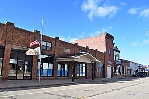
Downtown Wenona, including its municipal building
|
|

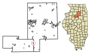
Location in Marshall County, Illinois
|
|
| Country | United States |
| State | Illinois |
| Counties | Marshall, LaSalle |
| Townships | Evans, Osage |
| Area | |
| • Total | 0.736 sq mi (1.906 km2) |
| • Land | 0.736 sq mi (1.906 km2) |
| • Water | 0.00 sq mi (0.00 km2) |
| Elevation | 689 ft (210 m) |
| Population
(2020)
|
|
| • Total | 974 |
| • Density | 1,323.37/sq mi (511.10/km2) |
| Time zone | UTC-6 (CST) |
| • Summer (DST) | UTC-5 (CDT) |
| ZIP code |
61377
|
| Area code(s) | 815 |
| FIPS code | 17-79813 |
| GNIS feature ID | 2397256 |
| Wikimedia Commons | Wenona, Illinois |
Wenona is a city in Illinois, a state in the United States. It is located in two counties: Marshall and LaSalle. In 2020, about 974 people lived there. The part of Wenona in Marshall County is near the larger city of Peoria. The smaller part in LaSalle County is close to Ottawa.
Contents
History of Wenona
Early Days and Growth
The first buildings in Wenona appeared around 1852. These included homes for railroad workers, a freight station, and a passenger station. The house for Gr. W. Goodwell, who was Wenona's first station agent and postmaster, was also finished that year.
In June 1854, the first Presbyterian Church was established. Later that year, a merchant named W.M. Brown arrived with many goods, and a new building was built for his store. The Illinois Central Railroad Company officially planned the town on May 15, 1855. At that time, Wenona had about nine buildings and 50 people living there. By 1858, it had grown a lot, becoming a busy village with hotels, stores, and other businesses.
The Wenona Coal Mine
A big reason for Wenona's growth was its coal mine. It was located in the northeast part of town, east of the railroad tracks. The mine opened in 1882 and was called the Wenona Coal Company. The coal vein was about 3 to 4 feet thick.
At its busiest, the mine employed 550 miners. They earned about $30,000 each month, which was a lot of money back then! For many years, they were paid in gold coins. The mine operated from 1882 until 1924, when it closed permanently. It was said that new union rules made it too expensive to mine such a thin layer of coal.
During the time the mine was open and during World War I, Wenona's population reached its highest ever: 1,892 people. People who lived there a long time ago said that the train station was so crowded the day after payday that the railroad couldn't fit all the passengers.
Wenona's Role in the Cold War
During the Cold War, the highest point in Wenona played a part in the defense of the United States. In April 1958, a radar station was built on top of the old coal mine's slag pile (a pile of waste material). This station was designed to spot incoming missiles and enemy airplanes that might be heading toward Chicago or Milwaukee.
About 20 soldiers worked at the radar station. It could detect aircraft up to 75,000 feet high and 200 miles away. The Wenona station was one of ten such stations set up around Chicago to protect the area. The station had two metal buildings and a radar antenna. The base of the slag pile was surrounded by a barbed-wire fence. Before building, 30 feet were leveled off the top of the pile, and a circular road was built.
The Army left Wenona in 1959. Before they left, they planted seeds on the mound, which grew into the beautiful trees you see there today.
Honoring History
The Wenona Coal Mine Historical Site was officially dedicated on August 10, 2018. This happened during the Wenona Days celebration, and members of the Wenona Historical Society were there.
Geography and Location
Most of Wenona is in Marshall County. However, two small areas, each about a block long, extend east into LaSalle County. In 2022, Wenona covered about 0.74 square miles of land.
Roads and Highways
Illinois Route 17 runs through Wenona as Chestnut Street. This highway goes east about 35 miles to Dwight and west about 20 miles to Lacon, which is the county seat of Marshall County.
Illinois Route 251 also joins Route 17 on Chestnut Street. Route 251 goes north about 7 miles to Lostant and south about 5 miles to Rutland.
Interstate 39 passes just west of Wenona. You can get onto I-39 from Exit 35, south of the city. I-39 goes north about 24 miles to La Salle and south about 40 miles to Normal.
Waterways
Water from Wenona flows north into small streams that feed into Sandy Creek. Sandy Creek then flows west to the Illinois River at Henry.
Population and People
| Historical population | |||
|---|---|---|---|
| Census | Pop. | %± | |
| 1870 | 879 | — | |
| 1880 | 911 | 3.6% | |
| 1890 | 1,053 | 15.6% | |
| 1900 | 1,486 | 41.1% | |
| 1910 | 1,442 | −3.0% | |
| 1920 | 1,203 | −16.6% | |
| 1930 | 1,005 | −16.5% | |
| 1940 | 967 | −3.8% | |
| 1950 | 1,005 | 3.9% | |
| 1960 | 1,005 | 0.0% | |
| 1970 | 1,054 | 4.9% | |
| 1980 | 1,025 | −2.8% | |
| 1990 | 950 | −7.3% | |
| 2000 | 1,065 | 12.1% | |
| 2010 | 1,056 | −0.8% | |
| 2020 | 974 | −7.8% | |
| U.S. Decennial Census | |||
As of the 2020 census, Wenona had 974 people living in 488 households. Most residents (about 89.6%) were White. Other groups included African American (2.7%), Native American (0.4%), and Asian (0.7%). About 5.8% of the population identified as Hispanic or Latino.
About 32.8% of households had children under 18 living with them. The average household had about 3 people. The average age of people in Wenona was 34.9 years old.
The average income for a household in Wenona was $35,179. For families, the average income was $55,833. About 19.6% of the population lived below the poverty line.
See also
 In Spanish: Wenona (Illinois) para niños
 | Kyle Baker |
 | Joseph Yoakum |
 | Laura Wheeler Waring |
 | Henry Ossawa Tanner |


