Loudoun Valley Estates, Virginia facts for kids
Quick facts for kids
Loudoun Valley Estates, Virginia
|
|
|---|---|

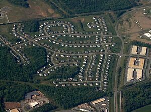
Aerial view of the Loudoun Valley Estates
|
|
| Country | |
| State | |
| County | |
| Area | |
| • Total | 2.83 sq mi (7.32 km2) |
| • Land | 2.81 sq mi (7.27 km2) |
| • Water | 0.02 sq mi (0.06 km2) |
| Elevation | 295 ft (90 m) |
| Population
(2010)
|
|
| • Total | 3,656 |
| • Density | 1,303/sq mi (503.2/km2) |
| Time zone | UTC−5 (Eastern (EST)) |
| • Summer (DST) | UTC−4 (EDT) |
| ZIP codes | |
| FIPS code | 51-47136 |
| GNIS feature ID | 2584868 |
Loudoun Valley Estates is a community in Loudoun County, Virginia, in the United States. It's known as a census-designated place (CDP). This means it's an area that looks like a town but isn't officially a city or town with its own local government.
In 2010, about 3,656 people lived here. Loudoun Valley Estates is a planned community built by Toll Brothers. It is located near the Ashburn area. The community is managed by a homeowners' association, which helps keep the neighborhood organized. You can easily get around using the Loudoun County Parkway.
Contents
Geography and Location
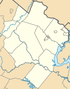
Loudoun Valley Estates is in the southeastern part of Loudoun County. It has several neighbors. To the south and west, you'll find Brambleton. To the north are Broadlands and Moorefield. The runways of Dulles International Airport are to the east.
This community is about 2 miles (3.2 km) southwest of the Dulles Greenway. It's also about 11 miles (18 km) south of Leesburg. Leesburg is the main town, or county seat, of Loudoun County. Washington, D.C., is about 32 miles (51 km) west-northwest of Loudoun Valley Estates.
The total area of Loudoun Valley Estates is about 2.8 square miles (7.3 square kilometers). A small part of this, about 0.02 square miles (0.06 square kilometers), is water. The area's water flows into Broad Run. This stream eventually joins the Potomac River.
The land here is gently rolling, meaning it has small hills and valleys. The average height above sea level is about 290 feet (88 meters). Around 500 people live in each square kilometer.
Climate and Weather
Loudoun Valley Estates has a humid subtropical climate. This means it has hot, humid summers and mild winters. The average yearly temperature is about 57°F (14°C).
August is usually the warmest month, with temperatures around 77°F (25°C). January is the coldest, with temperatures near 32°F (0°C). The area gets about 47 inches (1,188 mm) of rain each year. October is often the wettest month, while November is usually the driest.
Who Lives Here: Demographics
The 2010 census showed us who lived in Loudoun Valley Estates. Out of the 3,656 people:
- About 29.3% were white.
- Around 4.2% were African American.
- A small number, 0.3%, were American Indians and Alaska Natives.
- The largest group, 61%, were Asian.
- About 1.1% were from another race.
- Around 4.1% were from two or more races.
- About 3.3% of everyone living there was Hispanic or Latino.
Notable Residents
- Reem Daly, a contestant from the TV show Survivor, lives in Loudoun Valley Estates.
See also
 In Spanish: Loudoun Valley Estates (Virginia) para niños
 | Kyle Baker |
 | Joseph Yoakum |
 | Laura Wheeler Waring |
 | Henry Ossawa Tanner |


