
Moorefield, Virginia facts for kids
Quick facts for kids
Moorefield, Virginia
Moorefield Station
|
|
|---|---|
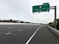
_at_Exit_7_(Virginia_State_Route_607-Loudoun_County_Parkway)_in_Moorefield_Station,_Loudoun_County,_Virginia.jpg)
SR 267 forms the northeast edge of Moorefield, with an exit at the Loudoun County Parkway providing direct access.
|
|

Moorefield, Virginia
Location in Northern Virginia

Moorefield, Virginia
Location in Virginia

Moorefield, Virginia
Location in the United States
|
|
| Country | |
| State | |
| County | |
| Area | |
| • Total | 1.14 sq mi (2.94 km2) |
| • Land | 1.14 sq mi (2.94 km2) |
| • Water | 0 sq mi (0.0 km2) |
| Elevation | 280 ft (90 m) |
| Population
(2010)
|
|
| • Total | 77 |
| Time zone | UTC−5 (Eastern (EST)) |
| • Summer (DST) | UTC−4 (EDT) |
| ZIP code |
20148 (Ashburn)
|
| FIPS code | 51-53030 |
| GNIS feature ID | 2584884 |
Moorefield is a special kind of community in Loudoun County, Virginia, United States. It is called a census-designated place (CDP). This means it is an area that the U.S. Census Bureau defines for gathering population data, but it is not an official town or city.
In 2010, this CDP was known as Moorefield Station. At that time, only 77 people lived there. By 2019, the number of people living in Moorefield grew a lot, reaching an estimated 1,976 residents.
Moorefield is a developing area that combines different types of buildings. It has homes, shops, and businesses all in one place. This type of area is called a mixed-use development. It is located near the Ashburn station, which is the last stop on the Silver Line of the Metrorail train system.
Contents
Exploring Moorefield's Location
Moorefield is found in the eastern part of Loudoun County, within the larger area of Ashburn. It sits on the southwest side of the Dulles Greenway, which is a major road (Virginia State Route 267).
Nearby Communities
Moorefield shares its borders with several other communities:
- To the northeast, it is next to Ashburn.
- To the northwest and west, it borders Brambleton.
- To the south, it is next to Loudoun Valley Estates.
Distance to Major Cities
Moorefield is about 10 miles (16 km) south of Leesburg. Leesburg is the main town and county seat for Loudoun County. It is also about 31 miles (50 km) west-northwest of Washington, D.C., the capital of the United States.
Land and Water Features
According to the U.S. Census Bureau, the Moorefield CDP covers a total area of about 2.9 square kilometers (which is about 1.1 square miles). Almost all of this area is land. Only a very small part, about 0.07%, is water.
The water in this area flows southeast into a stream called Broad Run. Broad Run then flows north and eventually joins the Potomac River.
Images for kids
-
SR 267 forms the northeast edge of Moorefield, with an exit at the Loudoun County Parkway providing direct access.
See also
 In Spanish: Moorefield Station (Virginia) para niños
