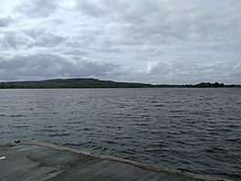
Lough Gara facts for kids
Quick facts for kids Lough Gara |
|
|---|---|
 |
|
| Location | County Sligo, County Roscommon |
| Coordinates | 53°57′N 8°27′W / 53.950°N 8.450°W |
| Native name | Loch Uí Ghadhra Error {{native name checker}}: parameter value is malformed (help) |
| Catchment area | 499.69 km2 (192.93 sq mi) |
| Basin countries | Ireland |
| Max. length | 4 mi (6.4 km) |
| Max. width | 2.5 mi (4.0 km) |
| Surface area | 12.57 km2 (4.85 sq mi) |
| Surface elevation | 66 m (217 ft) |
| Settlements | Monasteraden |
| Designated: | 7 June 1996 |
| Reference #: | 852 |
Lough Gara (pronounced 'Lock Gara') is a beautiful lake in Ireland. It stretches across parts of County Sligo and County Roscommon. This lake is very important for birds. It is known as an Important Bird Area. A big part of the lake is also a special Ramsar Site. This means it's protected because of its wetlands.
Contents
The Story of Lough Gara's Name
Long, long ago, Lough Gara had a different name. It was called Loch Techet. But around the 1200s, a powerful family called the O'Garas owned the land nearby. They renamed the lake "Loch Uí Ghadhra" after their family.
The first time this new name was written down was in 1285. Even though the O'Gara family lost control of their lands around 1650, their name stuck. Today, the lake is still called Lough Gara. The area around it is sometimes called the "O'Gara heartland."
Where is Lough Gara and How Big is It?
Most of Lough Gara is in the southern part of County Sligo. A smaller piece of the lake is in County Roscommon. The lake is about four miles long from north to south. At its widest point, it stretches about two and a half miles across.
Lough Gara is located southwest of the Curlew Mountains. The town of Ballaghaderreen is nearly four miles to the southwest. The town of Boyle is just over four miles from the lake's northeastern corner.
Rivers Flowing In and Out
Two main rivers feed water into Lough Gara. The Lung River flows into the lake from the southwest. The Breedoge River enters the lake from the southeast.
Water flows out of the main part of Lough Gara from its northeastern corner. This outflow forms a channel called Lower Lough Gara. From there, the water becomes the Boyle River. This river then flows past the town of Boyle and into Lough Key. Finally, it joins the mighty Shannon.
Lough Gara also has several islands. The main part of the lake is split into two sections. A strip of land and Clooncunny Bridge connect these two sections.
Ancient Man-Made Islands: Crannogs
Many of the islands you see on Lough Gara are not natural. They are actually man-made islands called crannógs. People built these islands a very long time ago.
Experts have studied these crannógs. An archaeologist named Christina Fredengran wrote about them. She found that some of these man-made islands were built over two thousand years ago! This shows that people lived and worked around Lough Gara for a very long time.
 | Bayard Rustin |
 | Jeannette Carter |
 | Jeremiah A. Brown |


