Loughman, Florida facts for kids
Quick facts for kids
Loughman, Florida
|
|
|---|---|

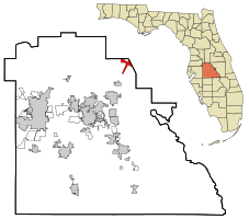
Location in Polk County and the state of Florida
|
|
| Country | United States |
| State | Florida |
| County | Polk |
| Area | |
| • Total | 3.76 sq mi (9.73 km2) |
| • Land | 3.47 sq mi (9.00 km2) |
| • Water | 0.28 sq mi (0.73 km2) |
| Elevation | 102 ft (31 m) |
| Population
(2020)
|
|
| • Total | 5,417 |
| • Density | 1,559.30/sq mi (602.06/km2) |
| Time zone | UTC-5 (Eastern (EST)) |
| • Summer (DST) | UTC-4 (EDT) |
| ZIP code |
33858
|
| Area code(s) | 863 |
| FIPS code | 12-41400 |
| GNIS feature ID | 0286130 |
Loughman (pronounced LOFF-mən) is a small community in Polk County, Florida, United States. It's located in the northeast part of the county, close to the border of Osceola County.
Loughman is known as a census-designated place (CDP). This means it's an area that looks like a town but isn't officially governed as one. In 2020, about 5,417 people lived there.
This area has grown a lot since 2000. Many people have moved here because it's close to popular places like Walt Disney World and the city of Orlando, Florida.
Contents
Exploring Loughman's Location
Loughman is found at specific coordinates: 28.246002 degrees North and -81.568470 degrees West. These numbers help pinpoint its exact spot on a map.
Land and Water Areas
According to the United States Census Bureau, Loughman covers a total area of about 3.8 square miles (9.7 square kilometers). Most of this area, about 3.7 square miles (9.0 square kilometers), is land. The rest, a small part of about 0.1 square miles (0.73 square kilometers), is water.
Loughman's Past: A Brief History
Loughman was settled not long after a railroad, called the South Florida Railroad, reached this area in 1883. When it was first settled, the place had a different name: Lake Locke.
The Dixie Highway Connection
Loughman was once on the route of the Dixie Highway. This was an important road that connected many parts of the eastern United States. The highway ran next to what is now US 17/92. This old road is now called Old Kissimmee Road. If you go north of the Osceola County line, it's called Old Tampa Highway.
You can still find a monument from 1930 that marks the Polk County line. Some parts of the old highway, which were paved with bricks, are still there today.
Who Lives in Loughman?
The number of people living in Loughman has changed over the years.
| Historical population | |||
|---|---|---|---|
| Census | Pop. | %± | |
| 2020 | 5,417 | — | |
| US Decennial Census | |||
In 2000, there were 1,385 people living in Loughman. They lived in 546 households, and 369 of these were families. The population density was about 372 people per square mile (143 people per square kilometer).
A Look at the Community
- In 2000, about 25.6% of households had children under 18 living there.
- More than half (52.9%) of households were married couples.
- About 23.7% of the people were under 18 years old.
- The average age of people living in Loughman was 38 years old.
Getting Around Loughman
Loughman is located on U.S. Highway 17/92. This is a main road that connects to other important routes.
Major Roads
- Poinciana Parkway: This road opened in 2016 and connects to Loughman.
- Ronald Reagan Parkway: Also known as County Road 54, this road also meets U.S. Highway 17/92 in Loughman.
Public Transportation
Bus service is available in Loughman through Citrus Connection. You can take a bus from Loughman to Posner Park. From there, you can connect to buses going to Haines City and Four Corners.
See also
 In Spanish: Loughman para niños
 | Chris Smalls |
 | Fred Hampton |
 | Ralph Abernathy |

