
Louisbourg Lighthouse Trail facts for kids
Quick facts for kids Louisbourg Lighthouse Trail |
|
|---|---|

View from Louisbourg Lighthouse Trail
|
|
| Length | About 2 kilometres (1.2 mi) on loop trail, 3 kilometres (1.9 mi) further to lookoff at Loraine Head. |
| Location | Fortress of Louisbourg National Historic Site |
| Trailheads | Louisbourg Lighthouse - 45° 54'24.1"N, 59° 57' 30.5"W (N45.9067, W59.9585) |
| Use | Hiking |
| Difficulty | Easy to strenuous |
| Season | Year round |
| Sights | Atlantic Ocean, Cabot Strait |
| Hazards | Severe weather Tick-borne diseases Mosquitos Biting flies |
| Surface | Loop Trail - Crushed stone, wood; Coastal Trail - natural surface, rock |
| Maintained by | Coastal Connections Trail Association |

The Louisbourg Lighthouse Trail is a fun hiking trail located on Cape Breton Island in Nova Scotia, Canada. It starts at Lighthouse Point, right by the famous Louisbourg Lighthouse. This lighthouse is super important because it was the first one ever built in Canada, way back in 1734!
Contents
Exploring the Trail's History
People have walked along this beautiful coastline for many years. There was always a small path connecting Lighthouse Point to a nearby village called Big Lorraine. Around 2008, a local group called the Coastal Connections Trail Association decided to make the path even better. They worked hard, and the first part of the trail officially opened in June 2010. This group of volunteers still takes care of the trail today, making sure it's great for everyone to enjoy.
What to See on the Trail
The Louisbourg Lighthouse Trail has two main parts: a loop trail and a more challenging coastal trail.
The Easy Loop Trail
The first part of the trail is perfect for everyone, no matter how much hiking experience you have. It begins at the parking area near Lighthouse Point. This section follows the ocean coast for about 2 kilometres (1 mi). It's made of hard-packed gravel, making it easy to walk on.
Along this part of the trail, you'll find special signs called interpretive panels. These signs tell you cool facts about the area's history and nature. You can learn about the land, the plants, and the animals that live there. There are also benches where you can rest and special spots with amazing views of the ocean.
Some parts of the trail go over wet ground, like a fen (a type of wetland). Here, the trail is built as a raised wooden boardwalk, so you stay dry. This loop trail is wide enough for two people to walk side-by-side. It's also easy to use with power wheelchairs and strollers. If you bring your pet, make sure they are on a leash and well-behaved. You'll pass by places like Lighthouse Cove and Morningstar Cove before the trail loops back towards the start.
The Challenging Coastal Trail
If you're looking for more adventure, the trail continues past the loop. This part is more rugged and challenging. It follows Gun Landing Cove beach, a historic spot where British soldiers landed their cannons in 1758 to attack the Fortress of Louisbourg. You can even see the remains of French defenses along the shore!
This section of the trail is narrower and has a natural surface, which means it can be wet in places. So, it's a good idea to wear sturdy shoes. There are still some boardwalks and bridges to help you cross wet areas. The trail then goes into the woods, past Eastern Gun Landing Cove Head, to a place called Brook Landing Cove (also known as Wolf's Cove). This was where General James Wolfe and his soldiers camped during their attack on the fortress.
From here, the trail continues for about 3 kilometres (2 mi) past Hammer Head Cove to a fantastic viewpoint at Lorraine Head. Beyond this viewpoint, a very rugged and informal path continues for another 3 kilometres (2 mi) to the village of Big Lorraine. This last section is only recommended for very experienced hikers.
How to Get to the Trail
To reach the Louisbourg Lighthouse Trail from Sydney, follow Trunk #22 to Louisbourg. As you enter the town, take the first left turn onto Havenside Road. Stay on Havenside Road until it ends at the lighthouse parking area. The start of the trail is at the far end of the parking lot.
Images for kids
-
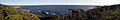
Morningstar Cove. Lorraine Head is far off to the east (left), then Gun Landing Cove and Western Gun Landing Cove Head are also to the east. Morningstar Cove is next to that in the left half of the photo. Lighthouse Cove is to the west (right side of the photo), followed by Louisbourg Lighthouse further to the right with the Fortress of Louisbourg in the distance beyond the lighthouse.
-
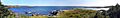
A view from Eastern Gun Landing Cove Head. Looking toward Hammer Head off to the east (left in photo). Then Big Cove and Brook Landing Cove (also known as Wolf's Cove) with Eastern Gun Landing Cove head in the photo centre. Gun Landing Cove and Western Gun Landing Cove Head are to the west. Louisbourg Lighthouse and the islands in the entrance to Louisbourg Harbour can be seen off to the west (far right) in the distance.
