Lower Mississippi water resource region facts for kids
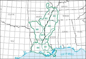
The Lower Mississippi water resource region is a huge area of land where all the water flows into the lower part of the Mississippi River or into the Gulf of Mexico. It's one of 21 main water regions in the United States. These regions help scientists at the United States Geological Survey (USGS) study how water moves across the country.
This region is known by a special code, HUC 08. It covers about 106,741 square miles (276,460 square kilometers) of land. That's a really big space! Inside this large region, there are 9 smaller areas called subregions. Each subregion has its own 4-digit code, from 0801 to 0809.
The Lower Mississippi region includes all the land that drains into the Mississippi River after it joins with the Ohio River. It also includes rivers like the Arkansas, Red, and White River in certain parts. Plus, it covers many coastal streams that flow into the Gulf of Mexico, from the Pearl River to the Sabine River. This important water region stretches across parts of several states: Arkansas, Kentucky, Louisiana, Mississippi, Missouri, and Tennessee.
Exploring the Lower Mississippi Water Subregions
The Lower Mississippi water resource region is divided into 9 smaller areas, each with its own unique features. These subregions help experts understand and manage the water resources more easily. Below is a list of these subregions, showing where they are and how big they are.
| Subregion Code | Subregion Name | What the Subregion Includes | States Covered | Size | Map |
|---|---|---|---|---|---|
| 0801 | Lower Mississippi–Hatchie subregion | This area covers the Mississippi River Basin from where the Ohio River joins it, down to the Horn Lake Creek Basin. | Arkansas, Kentucky, Mississippi, Missouri, and Tennessee. | 11,000 sq mi (28,000 km2) | |
| 0802 | Lower Mississippi–St. Francis subregion | This part of the Mississippi River Basin goes from the Horn Lake Creek Basin to include the Arkansas and White River Basins. | Arkansas, Mississippi, and Missouri. | 16,700 sq mi (43,000 km2) | |
| 0803 | Lower Mississippi–Yazoo subregion | This subregion includes the Mississippi River Basin from the Arkansas River Basin to the Yazoo River Basin. | Arkansas, Louisiana, Mississippi, and Tennessee. | 14,100 sq mi (37,000 km2) | |
| 0804 | Lower Red–Ouachita subregion | This area covers the Red River Basin below the Bayou Rigolette Basin, but not the Boeuf and Tensas River Basins. | Arkansas and Louisiana. | 20,500 sq mi (53,000 km2) | |
| 0805 | Boeuf–Tensas subregion | This subregion specifically includes the Boeuf and Tensas River Basins. | Arkansas and Louisiana. | 5,300 sq mi (14,000 km2) | |
| 0806 | Lower Mississippi–Big Black subregion | This part of the Mississippi River Basin goes from the Yazoo River Basin to the Lower Old River drainage boundary. | Louisiana and Mississippi. | 7,100 sq mi (18,000 km2) | |
| 0807 | Lower Mississippi–Lake Maurepas subregion | This subregion covers the Mississippi River Basin from the Lower Old River boundary to the Bonnet Carre Floodway. | Louisiana and Mississippi. | 5,870 sq mi (15,200 km2) | |
| 0808 | Louisiana Coastal subregion | This area includes the coastal drainage of Louisiana, including islands and waters, from the Red River Basin to the Sabine River. | Louisiana | 14,000 sq mi (36,000 km2) | |
| 0809 | Lower Mississippi subregion | This subregion covers the Mississippi River below the Bonnet Carre Floodway and the coastal drainage from the Pearl River Basin to the Atchafalaya Basin Floodway. | Louisiana | 9,460 sq mi (24,500 km2) |
 | Jewel Prestage |
 | Ella Baker |
 | Fannie Lou Hamer |


