
Lungern facts for kids
Quick facts for kids
Lungern
|
||
|---|---|---|
 |
||
|
||

Lungern
Location in Switzerland

Lungern
Location in Canton of Obwalden
|
||
| Country | Switzerland | |
| Canton | Obwalden | |
| District | n.a. | |
| Area | ||
| • Total | 46.47 km2 (17.94 sq mi) | |
| Elevation | 715 m (2,346 ft) | |
| Population
(Dec 2020 )
|
||
| • Total | 2,138 | |
| • Density | 46.008/km2 (119.16/sq mi) | |
| Postal code |
6078
|
|
| Surrounded by | Brienzwiler (BE), Giswil, Hasliberg (BE), Hofstetten bei Brienz (BE), Kerns, Meiringen (BE), Sachseln | |

Lungern is a small town, also called a municipality, in the canton of Obwalden in Switzerland. It is known for Lake Lungern and includes the main village of Lungern, plus the smaller areas of Bürglen, Kaiserstuhl, and Obsee.
Contents
Exploring Lungern's Geography

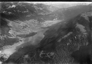
The village of Lungern is located about 750 meters (2,460 feet) above sea level. It sits in the highest part of the Obwalden canton. You can find it on the eastern shore of Lake Lungern and at the bottom of the Brünig Pass.
Lungern is the highest village in the Sarneraa-Valley. It's in a natural bowl that's only open to the north. Steep, wooded hills and rocks surround it on all other sides.
The town's area stretches all the way to the Brünig Pass in the southwest. On its northwestern side, the town's border follows the Wilerhorn and Höch Gumme mountains. It also includes the entire Lake Lungern. To the east, the border reaches the Hochstollen and Chingstuel mountains. It also covers the Güpfi mountain and part of the Kleine Melchtal valley.
Besides the main village of Lungern, the municipality also includes:
- Kaiserstuhl and Bürglen, which are at the northern end of the lake.
- Obsee, which is at the southwestern end of the lake.
The total area of Lungern is about 46.33 square kilometers (17.89 square miles). A large part of this land is used for farming, pastures, and forests.
A Look at Lungern's History


The first official record of Lungern dates back to 1275. It was found in a tax list for the bishop of Konstanz in Germany. The town was mentioned as Lutigern and de Lungern.
Travel to Lungern became easier in 1861 when an old road was built over the Brünig Pass. About 25 years later, in 1886, the first mail carriages started using this pass. However, this only lasted two years. In 1888, a railroad opened from Brienz to Alpnachstad (now part of Alpnach).
In 1887, the Eibach river flooded, damaging the old village church. Six years later, in 1893, a new church was built in the Neo-Gothic style.
At the end of the 18th century, the people of Lungern worked very hard for many years to lower the level of the lake. They did this to create more land for farming, homes, and a sawmill. However, about 80 years later, this new land was lost. In 1922, a company called CKW built a new dam and started a power station at the lake. Today, the local power station (EWO) still uses the water from Lake Lungern to make electricity. In 1942, the railroad line over the Brünig Pass was made electric.
People and Jobs in Lungern
Lungern currently has about 2,120 residents. The number of people living here is quite steady. However, there are more older people compared to the total population. About 17.5% of Lungern's population is of retirement age. This is higher than the average of 12% for the canton.
Who Lives in Lungern?
As of 2007, about 8.6% of the people in Lungern were from other countries. Over the past 10 years, the population has grown by about 2.6%. Most people in Lungern (94.8%) speak German. Albanian is the second most common language (2.2%), followed by French (0.7%). In 2000, there were 681 homes in Lungern.
Many adults in Lungern have completed higher education. About 71.5% of people aged 25 to 64 have finished either high school or a university/college degree.
How People Make a Living

Lungern has a very low unemployment rate, around 0.6%. In 2005, many people worked in different areas:
- 156 people worked in farming and forestry.
- 443 people worked in manufacturing and construction.
- 394 people worked in services like shops, hotels, or teaching.
Agriculture, especially raising cattle and dairy farming, is very important to Lungern's economy. Most farms are run by local highlanders and are located on the slopes of the valley, not just at the bottom.
Lungern also has a strong industrial sector. Some of the main employers include:
- Gasser Felstechnik: This company has 300 employees and specializes in making rock faces safe to prevent rockfalls and landslides.
- neue Holzbau AG: With over 70 employees, this company makes pre-built wooden structures and special wood products.
- H-P Gasser Membranbau: This company has over 80 employees and focuses on membrane structures and skylights.
- Sutter Fahrzeugbau: They are experts in building vehicle bodies and commercial vehicles.
These companies, located mostly in the Obsee area, provide many jobs. They employ not only people from Lungern but also from the wider Sarner-Aa valley and the Haslital region.
Population Over Time
Here's how Lungern's population has changed over the years:
| Year | Population |
|---|---|
| 1790 | 1,234 |
| 1850 | 1,413 |
| 1900 | 1,828 |
| 1950 | 1,878 |
| 1990 | 1,859 |
| 2000 | 1,965 |
| 2005 | 1,950 |
| 2006 | 1,975 |
| 2007 | 2,023 |
| 2008 | 2,035 |
Weather in Lungern
From 1961 to 1990, Lungern typically had rain on about 150 days each year. On average, it received about 1491 millimeters (58.7 inches) of rain. August was usually the wettest month, with about 163 millimeters (6.4 inches) of rain over 14 days. June had the most rainy days (about 15), but with slightly less rain overall (158 millimeters or 6.2 inches). October was the driest month, with about 88 millimeters (3.5 inches) of rain over 14 days.
Churches and Chapels
Lungern has one Catholic church and five smaller chapels. The main church is quite new, built about 110 years ago. The old church was destroyed when the lake flooded. The chapels are located in different parts of the village, including Dorfkapelle (village chapel), Obseekapelle, Kapelle Bürglen, Kapelle Breitenfeld, and Kappele Krummelbach.
Fun Things to See and Do
If you visit Lungern, here are some interesting places:
- The old church tower (Alter Kirchturm), the new Neo-Gothic church, and the small area called Obsee.
- Take the Lungern-Turren cable car up to Turren, then you can hike to Schönbüel for amazing views.
- Visit the underground shooting range.
Getting Around Lungern
The Brünig railway line runs through Lungern. This train line connects Interlaken and Lucerne. Both the Lungern station and Kaiserstuhl OW station are in the municipality. In 2013, trains ran hourly in both directions from these stations.
See also
 In Spanish: Lungern para niños
