
Hasliberg facts for kids
Quick facts for kids
Hasliberg
|
||
|---|---|---|

Hasliberg Reuti
|
||
|
||

Hasliberg
Location in Switzerland

Hasliberg
Location in Canton of Bern
|
||
| Country | Switzerland | |
| Canton | Bern | |
| District | Interlaken-Oberhasli | |
| Area | ||
| • Total | 41.74 km2 (16.12 sq mi) | |
| Elevation
(Goldern)
|
1,082 m (3,550 ft) | |
| Population
(Dec 2020 )
|
||
| • Total | 1,158 | |
| • Density | 27.743/km2 (71.85/sq mi) | |
| Postal code |
6083-6086
|
|
| Localities | Hohfluh, Wasserwendi, Goldern, Reuti | |
| Surrounded by | Innertkirchen, Kerns (OW), Lungern (OW), Meiringen | |

Hasliberg is a cool place in Switzerland. It's a municipality found in the Interlaken-Oberhasli area of the canton of Bern. Hasliberg sits on a sunny hillside, high above the Aare river valley.
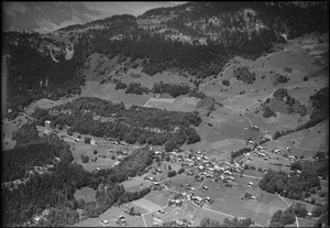
This area is made up of four main villages. From west to east, they are Hohfluh, Wasserwendi, Goldern, and Reuti. Hasliberg is super popular for winter sports like skiing and snowboarding. It's also home to an international boarding school called the Ecole d'Humanité in Goldern.
Contents
A Look at Hasliberg's Past

Hasliberg was first mentioned way back in 1358. Its name comes from an old German word for "hazel" trees. For a while, it was known as Hasleberg, but since 1923, it's been called Hasliberg.
People have lived here since the Middle Ages. Back then, Hasliberg was part of the Oberhasli region. In 1334, the city of Bern took control of Oberhasli.
How People Lived Long Ago
For many years, people in Hasliberg were farmers. They grew crops in the valleys and raised cows and horses in the mountains during different seasons. They also made cheese from the milk.
Starting in the 1300s, they began digging for iron ore in the nearby hills. They built special furnaces to melt the iron. Many people worked cutting timber or making charcoal for these furnaces. They also earned a little money from travelers crossing the Brünig Pass. Sometimes, Hasliberg residents even had small fights with their neighbors over grazing land for their animals.
Changes in Religion
In 1528, Hasliberg, like the rest of Bern, changed its religion to Protestantism. A chapel in Wasserwendi was taken down. For a long time, people went to church in Meiringen. Later, in 1939, a Protestant church was built in Hohfluh. It became the main church for Hasliberg in 1967. A Catholic chapel opened in the village in 1977.
Growth and Tourism
In the 1800s, Hasliberg's population grew a lot. But there wasn't enough farmland for everyone. So, many people started making things at home, like silk or linen, or carving wood. Others moved to different countries, especially the United States.
Things really changed when the Brünig railway line was built in 1888. A road to Meiringen also opened in 1890. This brought more money and lots of tourists! Hotels started opening, and by 1912, Hasliberg had over 600 hotel rooms.
However, World War I in 1914 hurt the tourism business. After World War II, tourism came back. Many new hotels and vacation homes were built. Today, tourism is the main way Hasliberg makes money.
Hasliberg's Geography
.jpg)


Hasliberg is located on a hillside that faces southwest. It's about 1,000 m (3,300 ft) high, above the Aare river valley. The four villages of Hohfluh, Wasserwendi, Goldern, and Reuti are spread out along this hillside.
To the north and east, the land goes even higher. The highest points are Glogghüs at 2,534 m (8,314 ft) and Planplatten at 2,245 m (7,365 ft).
Hasliberg covers an area of 41.74 km2 (16.12 sq mi). A big part of this land, about 52.5%, is used for farming. Forests cover about 32.1% of the area. The rest includes buildings, roads, rivers, and rocky, unproductive land.
Hasliberg's Coat of Arms
The blazon of Hasliberg's coat of arms shows a gold shield with four red stars arranged like a cross. Below them is a black hill with five rounded peaks.
People of Hasliberg
Hasliberg has a population of 1,158 people (as of December 2020[update]). About 16.7% of the people living here are from other countries (As of 2011[update]).
Most people in Hasliberg speak German, about 89.8% (as of 2000[update]). English is the second most common language, spoken by 3.5% of the people. Albanian is third, spoken by 1.3%.
Age Groups
In 2011, children and teenagers (up to 19 years old) made up 24.9% of the population. Adults (20-64 years old) were 55.9%, and seniors (over 64 years old) were 19.2%.
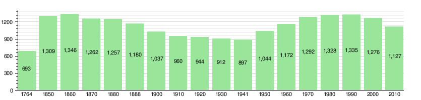
Population Changes Over Time
The chart below shows how Hasliberg's population has changed through history:
Hasliberg's Economy
In 2011, Hasliberg had a very low unemployment rate of 0.57%. Many people work in the municipality.
Main Job Areas
- Primary sector: This includes jobs like farming and forestry. About 168 people worked in this area in 2008.
- Secondary sector: This includes jobs in manufacturing and construction. About 48 people worked here in 2008.
- Tertiary sector: This is the largest sector, with 568 people working in jobs like hotels, restaurants, transportation, education, and healthcare.
Many people who live in Hasliberg also work there. In 2000, about 77.2% of workers lived and worked in the municipality. About 14.4% of workers used public transportation, and 39.7% drove their own cars.
Religion in Hasliberg
Based on the 2000 census, most people in Hasliberg, about 72.1%, belong to the Swiss Reformed Church. About 11.8% are Roman Catholic. There are also smaller groups of other Christian faiths, Jewish people, and Muslims. Some people don't belong to any church.
Education in Hasliberg
In Hasliberg, about 51.7% of the population has finished high school (upper secondary education). About 14.2% have gone on to higher education, like university.
School System
The Canton of Bern has a specific school system:
- One year of optional Kindergarten.
- Six years of Primary school.
- Three years of lower Secondary school, where students are grouped by their abilities.
After this, students can continue their education or start an apprenticeship (learning a trade).
During the 2011-12 school year, 206 students attended schools in Hasliberg. There was one kindergarten class with 24 students and five primary classes with 84 students. Some students also attended private schools.
Getting Around Hasliberg
.jpg)
You can reach the villages of Hasliberg by road from the Brünig Pass. The Brünig-Hasliberg train station is about 4 km (2.5 mi) from Hohfluh and 8 km (5.0 mi) from Reuti. A PostBus Switzerland service connects the station to the villages.
There's also a cable car that goes from the town of Meiringen in the valley up to Reuti. From Reuti, a system of Gondola lifts takes you even higher to Planplatten, which is over 2,200 m (7,200 ft) high, stopping at Mägisalp along the way. Other lifts connect Wasserwendi to Käserstatt.
See also
 In Spanish: Hasliberg para niños
