
Meiringen facts for kids
Quick facts for kids
Meiringen
|
||
|---|---|---|
 |
||
|
||

Meiringen
Location in Switzerland

Meiringen
Location in Canton of Bern
|
||
| Country | Switzerland | |
| Canton | Bern | |
| District | Interlaken-Oberhasli | |
| Area | ||
| • Total | 40.63 km2 (15.69 sq mi) | |
| Elevation | 595 m (1,952 ft) | |
| Population
(Dec 2020 )
|
||
| • Total | 4,666 | |
| • Density | 114.841/km2 (297.44/sq mi) | |
| Postal code |
3860
|
|
| Surrounded by | Brienz, Brienzwiler, Grindelwald, Hasliberg, Innertkirchen, Lungern (OW), Schattenhalb | |

Meiringen is a town in the canton of Bern in Switzerland. It's part of the Interlaken-Oberhasli area. Besides the main village of Meiringen, the town also includes smaller places like Balm, Brünigen, and Unterbach.
Meiringen is famous for two cool things! First, it's near the Reichenbach Falls. This waterfall is where the fictional detective Sherlock Holmes had his final fight with his enemy, Professor Moriarty. Second, Meiringen is also known for being the place where the sweet treat called meringue was supposedly invented.
Contents
- Meiringen's Location and Landscape
- Meiringen's Past: A Look Back in Time
- Meiringen's People: Who Lives Here?
- Things to See in Meiringen
- Meiringen's Economy: How People Work
- Religion in Meiringen
- Getting Around Meiringen: Transport
- Learning in Meiringen: Education
- Famous People from Meiringen
- Meiringen's Weather
- See also
Meiringen's Location and Landscape

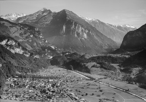
Meiringen is in the eastern part of the Bernese Oberland region. It sits in a valley of the Aare river, called Haslital. This valley is upstream from Lake Brienz.
The town is located at the base of several important mountain passes. These passes are like mountain roads that connect Meiringen to other parts of Switzerland. For example, the Brünig Pass leads to central Switzerland. The Grimsel Pass goes to the Rhone valley in southern Switzerland.
On one side of the Aare river, Meiringen goes from about 600 meters (1,968 feet) high in the valley to the Brünig Pass at 1,008 meters (3,307 feet). It even reaches up to 1,375 meters (4,511 feet) on the slopes of the Wilerhorn. On the other side, it stretches into the Alps, reaching 3,191 meters (10,469 feet) at the top of the Wellhorn.
The area of Meiringen is about 40.59 square kilometers (15.67 sq mi).
- About 43.7% of this land is used for farming.
- Around 32.7% is covered by forests.
- About 7.5% has buildings or roads.
- A small part (1.3%) is rivers or lakes.
- The remaining 15.0% is unproductive land, like rocky areas.
Meiringen's Past: A Look Back in Time


Meiringen was first mentioned in records in 1234. People lived in this area very early, in the Early Middle Ages. This was because of its important location near several mountain passes.
The first church in the village was built around the 9th or 10th century. After a flood destroyed it, a new church, St. Michael, was built. The current St. Michael church is from the 15th century.
A castle called Restiturm castle was built in the 13th century. Another fortress, Wyghus, was mentioned in 1333 but was later destroyed.
Meiringen was always the main town for the surrounding valley, known as Talschaft. It was an important center for trade. In 1275, it even formed an alliance with the city of Bern.
For a long time, Meiringen was the capital of the Oberhasli District. Even today, some government offices are still there.
Meiringen was the only town in the valley with a yearly fair, starting in 1417. This later became a weekly market. Traders from far away came to buy cattle, horses, and cheese. Until the 1800s, most people in the valley worked in farming or raising animals.
Over the years, floods from the Aare river caused problems. Some villages were even destroyed. Walls were built to protect the town, and a big project in the late 1800s helped control the river.
After 1800, the population grew, and many people became poor. Some even moved to America. But in the late 1800s, tourism started to bring new money to the valley. New roads were built over the mountain passes, making it easier for visitors to arrive.
The Brünigbahn (Brünig railway) opened in 1888, bringing even more tourists. After fires in 1879 and 1891, much of the village was rebuilt with tourists in mind. By 1913, Meiringen had 18 hotels!
In 1892, the famous writer Sir Arthur Conan Doyle visited the Reichenbach Falls. He was so inspired that he used the falls as the place where Sherlock Holmes and Professor Moriarty had their final battle in his story The Final Problem.
During World War II, tourism stopped. The government created jobs by opening a military airfield and other facilities. Today, you can visit the municipal museum and the Sherlock Holmes Museum, which opened in 1991.
Meiringen's People: Who Lives Here?

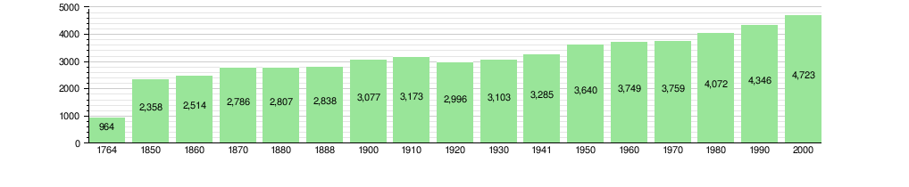
Meiringen has a population of about 4,700 people. Around 14% of the people living here are from other countries.
Most people in Meiringen speak German as their main language (about 88.7%). Other languages spoken include Serbo-Croatian and Portuguese.
About 24% of the population are children and teenagers (0–19 years old). Adults (20–64 years old) make up about 59%, and seniors (over 64 years old) are about 17%.
The number of people living in Meiringen has changed over time:
Things to See in Meiringen


Meiringen has several important landmarks. The Hotel Sauvage, the Swiss Reformed church, and the Reichenbachfall-Bahn (a funicular railway) are all listed as important cultural sites. The village of Meiringen and the small village of Brünigen are also recognized as Swiss Heritage Sites.
Just east of Meiringen's center are the ruins of Restiturm castle. This castle used to guard the trade routes that went through the village.
A special museum dedicated to Sherlock Holmes is located in the basement of the old English Church. This area is now called Conan Doyle Place. The museum has a very detailed and real-looking copy of Sherlock Holmes's living room at 221B Baker Street in London. Sir Arthur Conan Doyle's daughter, Dame Jean Conan Doyle, officially opened the museum in May 1991.
Meiringen's Economy: How People Work
Meiringen has a low unemployment rate, around 1.9%. This means most people who want to work can find jobs.
People in Meiringen work in different types of jobs:
- Primary Sector: About 186 people work in farming. This includes growing crops and raising animals.
- Secondary Sector: Around 528 people work in this area. This includes jobs in manufacturing (making things), mining, and construction (building things).
- Tertiary Sector: The largest group, about 1,762 people, work in this sector. These jobs include sales, transportation, hotels and restaurants, finance, education, and healthcare.
Many people who live outside Meiringen come into the town for work. Also, some people from Meiringen travel to other towns for their jobs. About 10% of workers use public transport, and about 37% use a private car to get to work.
Religion in Meiringen

Based on a 2000 survey, most people in Meiringen belong to the Swiss Reformed Church (about 66%). About 17% are Roman Catholic.
There are also smaller groups of people who belong to other Christian churches, Orthodox churches, or other religions like Islam, Buddhism, and Hinduism. Some people do not belong to any church.
Getting Around Meiringen: Transport


Meiringen has a train station called Meiringen station. It's on the Brünig line, which is a special narrow-gauge railway that goes from Interlaken to Lucerne. Another station, Brünig-Hasliberg, is also within the town's area.
Meiringen station is also the end point for the local Meiringen–Innertkirchen railway. This train connects Meiringen to the nearby village of Innertkirchen.
You can also take the Reichenbachfall Funicular from a place called Willigen to the famous Reichenbach Falls. On the other side of the valley, there's a cable car that goes up to Reuti. From there, you can take Gondola lifts even higher up the mountain to Planplatten, which is over 2,200 meters (7,218 feet) high!
Meiringen is on important roads that connect to the Brünig Pass, Grimsel Pass, and Susten Pass. These roads are vital for travel between different parts of Switzerland.
The Meiringen air base is one of the main air bases for the Swiss Air Force. It's special because it still uses its aircraft cavern regularly. This base, located in Unterbach, is home to fighter jets like the F/A-18 Hornet.
Learning in Meiringen: Education
In Meiringen, many people have completed higher education. About 39% of the population have finished non-mandatory upper secondary education. About 9.5% have gone on to university or a specialized college.
The school system in the Canton of Bern starts with one year of kindergarten. Then, students go to six years of primary school. After that, there are three years of lower secondary school, where students are grouped by their abilities. After lower secondary, students can choose to continue their schooling or start an apprenticeship (learning a trade on the job).
During the 2009–10 school year, about 635 students attended classes in Meiringen. There were 5 kindergarten classes, 15 primary classes, and 12 lower secondary classes.
Meiringen also has a library called Bibliothek Kapellen. In 2008, it had almost 10,000 books and other media. It loaned out over 20,000 items that year.
Famous People from Meiringen
- Christian Menn (1927–2018), a famous bridge designer.
- Pierre Haubensak (born 1935), a painter.
Meiringen's Weather
Meiringen has a temperate oceanic climate. This means it has a long winter season. The average temperature is above 10°C (50°F) for about five months of the year. There's not too much rain, and most of the precipitation in winter is snow.
| Climate data for Meiringen (1991–2020) | |||||||||||||
|---|---|---|---|---|---|---|---|---|---|---|---|---|---|
| Month | Jan | Feb | Mar | Apr | May | Jun | Jul | Aug | Sep | Oct | Nov | Dec | Year |
| Mean daily maximum °C (°F) | 2.3 (36.1) |
4.7 (40.5) |
10.3 (50.5) |
14.7 (58.5) |
18.7 (65.7) |
21.9 (71.4) |
23.6 (74.5) |
23.0 (73.4) |
18.8 (65.8) |
14.0 (57.2) |
7.6 (45.7) |
2.5 (36.5) |
13.5 (56.3) |
| Daily mean °C (°F) | −1.1 (30.0) |
0.4 (32.7) |
5.0 (41.0) |
9.2 (48.6) |
13.2 (55.8) |
16.5 (61.7) |
17.9 (64.2) |
17.4 (63.3) |
13.6 (56.5) |
9.1 (48.4) |
3.7 (38.7) |
−0.5 (31.1) |
8.7 (47.7) |
| Mean daily minimum °C (°F) | −5.0 (23.0) |
−4.2 (24.4) |
−0.3 (31.5) |
3.1 (37.6) |
7.3 (45.1) |
11.0 (51.8) |
12.5 (54.5) |
12.1 (53.8) |
8.6 (47.5) |
4.6 (40.3) |
−0.1 (31.8) |
−3.9 (25.0) |
3.8 (38.8) |
| Average precipitation mm (inches) | 82 (3.2) |
72 (2.8) |
85 (3.3) |
90 (3.5) |
137 (5.4) |
148 (5.8) |
160 (6.3) |
174 (6.9) |
108 (4.3) |
92 (3.6) |
95 (3.7) |
98 (3.9) |
1,341 (52.8) |
| Average snowfall cm (inches) | 26 (10) |
28 (11) |
14 (5.5) |
4 (1.6) |
0 (0) |
0 (0) |
0 (0) |
0 (0) |
0 (0) |
1 (0.4) |
12 (4.7) |
27 (11) |
112 (44) |
| Average precipitation days (≥ 1.0 mm) | 10.0 | 9.0 | 10.2 | 10.1 | 12.3 | 14.0 | 14.0 | 13.8 | 10.3 | 9.8 | 10.0 | 10.8 | 134.3 |
| Average snowy days (≥ 1.0 cm) | 4.3 | 4.2 | 2.7 | 0.9 | 0.1 | 0.0 | 0.0 | 0.0 | 0.0 | 0.1 | 2.0 | 4.1 | 18.4 |
| Average relative humidity (%) | 85 | 79 | 73 | 70 | 73 | 75 | 76 | 79 | 81 | 83 | 84 | 86 | 79 |
| Source: MeteoSwiss | |||||||||||||
See also
 In Spanish: Meiringen para niños
