
Grindelwald facts for kids
Quick facts for kids
Grindelwald
|
||
|---|---|---|

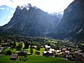
View to southeast to the disappearing Lower Grindelwald Glacier with parts of the Mättenberg to the left, the Hörnli (2710 m a.s.l.) to the right, and the Fiescherhorn (4049 m a.s.l.) in the back
|
||
|
||

Grindelwald
Location in Switzerland

Grindelwald
Location in Canton of Bern
|
||
| Country | Switzerland | |
| Canton | Bern | |
| District | Interlaken-Oberhasli | |
| Area | ||
| • Total | 171.33 km2 (66.15 sq mi) | |
| Elevation
(Railway station Grindelwald)
|
1,034 m (3,392 ft) | |
| Population
(Dec 2020 )
|
||
| • Total | 3,800 | |
| • Density | 22.18/km2 (57.4/sq mi) | |
| Demonym(s) | German: Grindelwaldner(in) | |
| Postal code |
3818 Grindelwald, 3816 Burglauenen,
|
|
| Localities | Alpiglen, Burglauenen, Grund, Itramen, Isch, Mühlebach, Mettenberg, Schwendi, Tschingelberg, Wärgistal, Büössalp, Burg, Alp Grindel, First, Grosse Scheidegg, Pfingstegg | |
| Surrounded by | Brienz, Brienzwiler, Fieschertal (VS), Guttannen, Innertkirchen, Iseltwald, Lauterbrunnen, Lütschental, Meiringen, Schattenhalb | |
| Twin towns | Azumi, now Matsumoto (Japan) | |

Grindelwald is a beautiful village and a local government area (called a municipality) in the Bern canton of Switzerland. It's part of the Interlaken-Oberhasli district. Besides the main village, the municipality includes smaller areas like Alpiglen and Burglauenen.
The village of Grindelwald is located about 1,034 m (3,392 ft) above sea level. It was first mentioned way back in 1146. Since the 1800s, it has become a very popular place for tourists in both Switzerland and the Alps. High mountains like the Wetterhorn and the Eiger surround it, forming a natural wall. Grindelwald is part of the Jungfrau Region, which is a famous area for visitors.
Grindelwald is connected to the town of Interlaken by the Bernese Oberland Railway. It's also the starting point for the Wengernalp Railway, which takes you up to Kleine Scheidegg. From Kleine Scheidegg, you can hop on the Jungfrau Railway, which is the highest railway in Europe! This railway leads to the amazing Jungfrau-Aletsch protected area.
| Top - 0-9 A B C D E F G H I J K L M N O P Q R S T U V W X Y Z |
What is the Coat of Arms of Grindelwald?
The coat of arms for Grindelwald shows a red shield with a silver bar across it. On the bar, there's a black chamois (a type of goat-antelope) standing up. Around it are seven silver stars.
Exploring the History of Grindelwald
Grindelwald was first mentioned in 1146 as Grindelwalt. This name likely comes from old German words meaning "barrier" and "forest," describing the valley's natural features. A local story says the name came from two monks who explored the area and talked about "stones" (Grinden) and "forests" (Wald).


The oldest signs of people living here are neolithic (Stone Age) tools found near the village. Some Roman era coins have also been discovered. A castle was built on Burgbühl hill above the village during the High Middle Ages.
In 1146, King Conrad III gave land in Grindelwald to the Interlaken Monastery. Over time, the Monastery bought more land and became very powerful in the valley. In 1528, the city of Bern adopted the Protestant Reformation (a big change in religion). Bern made Grindelwald become Protestant too, even though many villagers didn't want to. Grindelwald then became part of a district controlled by Bern.
The first church in the village was made of wood in the mid-1100s. It was replaced by a stone church, St. Mary's, in 1180. The church you see today was built in 1793. On August 18, 1892, a huge fire destroyed a large part of the village. Strong winds and a dry period made the fire spread quickly. In just two hours, 116 buildings were lost, and 412 people became homeless.

Tourism in Grindelwald began in the late 1700s when visitors discovered its beautiful scenery. Pictures of the area became famous worldwide. In the 1800s, many English climbers came to conquer the tall mountains around the valley. Climbing the Wetterhorn in 1854 is seen as the start of the "golden age of alpinism," a time when many famous mountain climbs happened. The first successful climb of the north face of the Eiger in 1938 was also a huge moment in climbing history.
The road to Grindelwald was built between 1860 and 1872. The Bernese Oberland railway arrived in 1890. These made it much easier for tourists to visit. In 1888, Grindelwald became the first place in the Bernese Oberland to offer winter activities like sleigh rides, curling, skating, and skiing. By 1914, there were 33 hotels! A special rack railway was built to Kleine Scheidegg in 1893, and it was extended to the Jungfraujoch in 1912. Many ski lifts, cable cars, and hiking trails were built to help tourists explore the mountains. Today, almost all of Grindelwald's economy comes from tourism. The V-cableway, opened in 2020, is the newest big development.
Grindelwald's Geography and Mountains
Grindelwald is a large municipality with seven mountain communities. The main village sits slightly above the Black Lütschine river. The area is surrounded by many famous mountains. These include the Faulhorn, Wetterhorn, Eiger, and the Mönch (which is the highest peak in the municipality). The Kleine Scheidegg and the Grosse Scheidegg are two important mountain passes in the valley.
About 28.9% of Grindelwald's land is used for farming, and 16.4% is covered by forests. A small part (1.8%) has buildings and roads. Rivers and lakes make up 0.8% of the land. More than half (52.1%) of the land is unproductive, meaning it's too rocky or covered by glaciers.
The highest peaks, from the Wellhorn and Wetterhorn to the Eiger and Mönch, are part of the Jungfrau-Aletsch protected area. This area is recognized as a World Heritage Site by UNESCO.

People and Population in Grindelwald


Grindelwald has a population of about 3,800 people. Around 18% of the people living here are foreign nationals. Most people (about 87%) speak German as their main language. Other languages spoken include Portuguese and French.
In 2010, about 17.5% of the population were children and teenagers (0–19 years old). Adults (20–64 years old) made up 62.5%, and seniors (over 64 years old) made up 20%.
The number of people living in Grindelwald has changed over time:

Important Heritage Sites

The Jungfraubahn, a mountain railway that goes up the Jungfrau mountain, is a very important heritage site in Switzerland. The area around Kleine Scheidegg is also a protected heritage site. Both the Jungfraubahn and Kleine Scheidegg are shared between Grindelwald and the nearby municipality of Lauterbrunnen.
Grindelwald's Economy and Jobs

The main street in Grindelwald, Dorfstrasse, is where most of the businesses are. The economy of Grindelwald relies heavily on tourism.
In 2008, there were over 2,700 people working in Grindelwald.
- About 334 people worked in farming and related activities (the primary sector).
- Around 393 people worked in manufacturing and construction (the secondary sector).
- The largest number, 1,987 people, worked in services like hotels, restaurants, and shops (the tertiary sector).
Many people who work in Grindelwald travel in from other areas. About 9.2% of workers use public transport, and 36.2% use a private car to get to work.
Religion in Grindelwald
Based on a 2000 census, most people in Grindelwald (about 70.6%) belonged to the Swiss Reformed Church (a Protestant church). Around 17% were Catholic. A smaller number of people belonged to other Christian churches, or other religions like Islam or Buddhism. About 3.5% of the population did not belong to any church.
Climate and Seasons

Grindelwald gets a lot of rain or snow, averaging about 1,450 mm (57 in) of precipitation per year. August is usually the wettest month, while February is the driest.
Because the municipality stretches from lower valleys to high mountain peaks, the temperatures change a lot.
- The lower parts of the valley are in the Montane zone and Subalpine zone, where you find coniferous trees and more snowfall.
- Higher up is the Alpine zone, which is like a cold, open grassland.
- Above 3,000 meters, it's the Ice cap climate zone, where it's very cold and covered in ice and snow.
Getting Around: Transport in Grindelwald

Grindelwald railway station, in the center of the village, is a busy place. You can catch trains from the Berner Oberland Bahn (BOB) to Interlaken. You can also take trains from the Wengernalpbahn (WAB) up to Kleine Scheidegg and then on to Wengen and Lauterbrunnen. From Kleine Scheidegg, you can switch to the Jungfraubahn, which goes inside the Eiger mountain all the way to the Jungfraujoch.
Besides the main station, there are eight other train stations within Grindelwald's municipality.
There are also several cable cars:
- The Gondelbahn Grindelwald-Männlichen takes you to Männlichen. From there, you can connect to another cable car to Wengen.
- The Eiger Express, a newer cable car, connects Grindelwald directly to Eigergletscher.
- Cable cars also go to First and Pfingstegg.
During the summer, buses run from Grindelwald to Meiringen over the Grosse Scheidegg pass, which is almost 2,000 meters high.
Winter Sports and Activities

Grindelwald is famous for its winter sports. It has slopes for all skill levels, from beginners to advanced skiers who can tackle the Eiger glacier. If you don't ski, you can still enjoy tobogganing (sledding) or walking on groomed winter hiking trails.
Grindelwald is also a common starting point for climbers heading up the Eiger and Wetterhorn mountains. In summer, it's a popular place for hiking, with many trails across the Alps.
The first person to ski here was an Englishman named Gerald Fox in 1881. He reportedly put on his skis in his hotel room and walked out through the hotel bar to the slopes!
Education in Grindelwald

In Grindelwald, about 40.5% of adults have completed non-mandatory high school education. About 7.4% have gone on to higher education, like university.
The school system in the Canton of Bern starts with one year of optional Kindergarten. Then, there are six years of primary school. After that, students attend three years of lower secondary school, where they are grouped by their abilities. After lower secondary, students can continue their education or start an apprenticeship.
In the 2010–11 school year, 341 students attended schools in Grindelwald. There were 55 kindergarten students, 187 primary students, and 99 lower secondary students.
Grindelwald also has a library called Bibliothek Grindelwald. In 2008, it had over 6,100 books and other media, and loaned out more than 10,700 items.
Famous People from Grindelwald
Many notable people have connections to Grindelwald:
- Christian Almer (1826–1898), a famous mountain guide who was one of the first to climb the Eiger.
- Ulrich Almer (1849–1940), another Swiss mountain guide who made many first climbs in the Alps.
- W. A. B. Coolidge (1850–1926), an American historian and mountaineer who lived here.
- Fritz Steuri (1879–1950), a Swiss mountain climber and skier.
- Peter Kaufmann-Bohren (1886–1971), a Swiss ski instructor and mountain guide.
- Oleg Protopopov (1932–2023) and Ludmila Belousova (1935–2017), Olympic figure skating champions.
- Martina Schild (born 1981), an alpine skier who won a silver medal at the 2006 Winter Olympics.
- Hedy Schlunegger (1923–2003), an Olympic gold medalist in downhill skiing in 1948.
- Gottfried Strasser (1854–1912), a Swiss pastor, poet, and writer.
- Richard Wagner (1813–1883), a famous German composer, also spent time here.
Images for kids
-
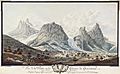
A depiction of Grindelwald in the 18th century by Niklaus Sprüngli
-
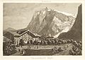
Grindelwald's first hotel, the "Black Eagle", with Wetterhorn and Upper Grindelwald Glacier, c. 1870. Etching by Heinrich Müller
-
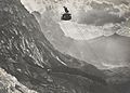
1909 view of the valley from the Wetterhorn Elevator
-
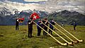
Alphorn Festival in Grindelwald area
-
Typically dispersed chalets with the Wetterhorn in background
-
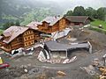
New houses with buried garages under construction in Grindelwald.
See also
 In Spanish: Grindelwald para niños
