
Guttannen facts for kids
Quick facts for kids
Guttannen
|
||
|---|---|---|

Handeck Hotel in Guttannen
|
||
|
||

Guttannen
Location in Switzerland

Guttannen
Location in Canton of Bern
|
||
| Country | Switzerland | |
| Canton | Bern | |
| District | Interlaken-Oberhasli | |
| Area | ||
| • Total | 200.85 km2 (77.55 sq mi) | |
| Elevation | 1,057 m (3,468 ft) | |
| Population
(Dec 2020 )
|
||
| • Total | 245 | |
| • Density | 1.2198/km2 (3.159/sq mi) | |
| Postal code |
3864
|
|
| Surrounded by | Fieschertal (VS), Gadmen, Grindelwald, Innertkirchen, Münster-Geschinen (VS), Obergesteln (VS), Oberwald (VS), Ulrichen (VS) | |

Guttannen is a small town, also called a municipality, in Switzerland. It's located in the Interlaken-Oberhasli area within the canton of Bern.
Contents
What's in a Name?
The name Guttannen comes from an old phrase. It means "by the good firs." This shows that the area likely had many fir trees long ago.
A Look Back in Time: Guttannen's History


Guttannen was first written about in 1377. Back then, it was called Guotentannon.
For a long time, Guttannen was part of a larger area called Hasli. It was also part of the church community of Meiringen. In 1334, the city of Bern took control of the entire Hasli area.
A small church was built in Guttannen in 1467. Later, when the whole canton of Bern changed to the Protestant Reformation, this church also became Protestant. It stayed connected to Meiringen until 1816, when Guttannen got its own independent church community. The original church was damaged by fire in 1723 and a new one was built.
In 1798, France invaded Switzerland. Guttannen became part of a new canton called Oberland. But in 1803, things changed again, and Guttannen returned to the Canton of Bern.
For many years, people in Guttannen made a living by farming in the valley. They also moved their animals to high mountain pastures in summer. Trading goods over the Grimsel Pass was also important. Because the growing season was short and the soil wasn't great, some people mined lead or zinc. Others carved wood or soapstone.
Life was often hard, and many people left Guttannen to find a better life. In the 17th and 18th centuries, some moved to Germany. Later, in the late 18th and 19th centuries, many went to the United States. They settled in places like the Carolinas, Pennsylvania, and Kentucky.
In the early 1800s, mountain climbers started visiting Guttannen. They wanted to explore the tall peaks nearby. Famous climbers like Louis Agassiz even trained guides here in the 1830s.
The Grimsel Pass road was built between 1894 and 1895. This road made it easier for people to visit and for goods to be traded. This helped the village grow.
Between 1925 and 1975, five hydroelectric dams and six reservoirs were built in the Grimsel Pass area. These projects brought a lot of wealth to Guttannen. The Kraftwerke Oberhasli (KWO) company was started in 1925 to manage these power plants. Today, KWO is the biggest employer in Guttannen. A modern road over the pass was also built between 1960 and 1986.
Guttannen's Natural Surroundings

Guttannen is located in the beautiful Bernese Oberland region, close to the Grimsel Pass. It's the highest village in the Haslital valley. The municipality stretches up the valley all the way to the top of the Grimsel Pass.
The Aare River starts from glaciers right here in Guttannen. There are four main lakes in the area: Lake Oberaar, Lake Grimsel, Lake Räterichsboden, and Lake Gelmer.
In the western part of Guttannen, you'll find impressive mountains like Schreckhorn, Lauteraarhorn, Finsteraarhorn, Agassizhorn, and Sidelhorn. The municipality also includes several large glaciers, such as Finsteraar Glacier and Unteraar Glacier.
Guttannen is a very large municipality for Switzerland. It's even bigger than an entire canton! Its elevation ranges from about 800 to 1,300 meters (2,600 to 4,300 feet) in the valley, up to the high alpine peaks.
About 3.8% of Guttannen's land is used for farming. Forests cover about 9.3% of the area. A small part, 0.5%, has buildings and roads. About 3.7% is covered by rivers or lakes. The largest part, 82.6%, is unproductive land, meaning it's mostly rocky mountains and glaciers.
Guttannen's Coat of Arms
The blazon (description) of Guttannen's coat of arms is: a black fir tree with a red trunk, standing between two red stars on a gold background.
Who Lives in Guttannen?


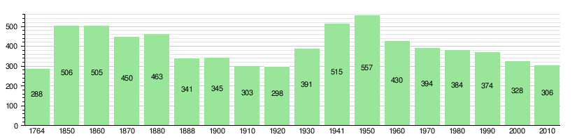
Guttannen has a population of about 300 people. In 2011, about 7% of the people living here were from other countries.
Most people in Guttannen speak German as their first language. In 2000, about 98.2% of the population spoke German.
In 2011, children and teenagers (ages 0-19) made up 19% of the population. Adults (ages 20-64) were 58.7%, and seniors (over 64) were 22.3%.
Here's how the population of Guttannen has changed over time:
Important Landmarks

The Grimsel dam (Grimselstaumauer) and the old Grimsel Pass hospice are very important. They are listed as Swiss heritage sites of national significance. This means they are protected because of their historical and cultural value.
How People Make a Living
In 2008, there were 218 people working in Guttannen.
- About 72 people worked in the primary sector, mostly in farming.
- About 58 people worked in the secondary sector, which includes making things and construction.
- About 88 people worked in the tertiary sector. This includes jobs in hotels, restaurants, and education.
The biggest employer in Guttannen is the Kraftwerke Oberhasli (KWO) company, which runs the hydroelectric power plants.
Most people who work in Guttannen also live there. However, many residents travel outside the municipality for work.
Religion in Guttannen
Guttannen is mainly an evangelical-reformed parish, which is a type of Protestant church.
In 2000, most people (86%) belonged to the Swiss Reformed Church. A smaller number (5.8%) were Roman Catholic.
Weather in Guttannen
Between 1981 and 2010, Guttannen had about 152 days of rain or snow each year. On average, it received about 1650 millimeters (65 inches) of precipitation.
The wettest month was May, with about 164 millimeters (6.5 inches) of rain or snow over 14.8 days. June had the most days of precipitation (15 days) but slightly less rain. October was the driest month.
Learning and Education

In Guttannen, about 55.6% of adults have finished high school (non-mandatory upper secondary education). About 8.4% have gone on to higher education, like a university.
The school system in the Canton of Bern starts with one year of optional Kindergarten. Then, students attend six years of Primary school. After that, there are three years of mandatory lower Secondary school. Students are grouped based on their abilities. After lower Secondary, students can continue their education or start an apprenticeship (on-the-job training).
During the 2011-2012 school year, 31 students attended classes in Guttannen. There was one kindergarten class with 6 students. The municipality had two primary classes with 25 students.
In 2000, 21 students lived and went to school in Guttannen. However, 15 students from Guttannen went to schools outside the municipality.
See also
 In Spanish: Guttannen para niños
