
Innertkirchen facts for kids
Quick facts for kids
Innertkirchen
|
||
|---|---|---|

View of Innertkirchen from the river Aare
|
||
|
||

Innertkirchen
Location in Switzerland

Innertkirchen
Location in Canton of Bern
|
||
| Country | Switzerland | |
| Canton | Bern | |
| District | Interlaken-Oberhasli | |
| Area | ||
| • Total | 236.61 km2 (91.36 sq mi) | |
| Elevation | 625 m (2,051 ft) | |
| Population
(Dec 2020 )
|
||
| • Total | 1,072 | |
| • Density | 4.5307/km2 (11.734/sq mi) | |
| Postal code |
3862-63
|
|
| Surrounded by | Engelberg (OW), Gadmen, Grindelwald, Guttannen, Hasliberg, Kerns (OW), Meiringen, Schattenhalb, Wolfenschiessen (NW) | |

Innertkirchen is a small village and municipality located in the Interlaken-Oberhasli area in the canton of Bern, Switzerland. It's a beautiful place surrounded by mountains and valleys. On January 1, 2014, another nearby village called Gadmen joined with Innertkirchen to form a larger municipality.
Contents
- A Look Back: History of Innertkirchen
- Exploring Innertkirchen: Geography
- Innertkirchen's Coat of Arms
- Who Lives Here? Demographics
- Population Changes Over Time
- Important Buildings: Heritage Sites
- Powering the Region: Industry
- How People Make a Living: Economy
- Beliefs and Churches: Religion
- Learning and Schools: Education
- Getting Around: Transportation
- Images for kids
- See also
A Look Back: History of Innertkirchen
Early Days and Roman Times

The name "Innertkirchen" is quite new, first appearing in 1834. It was created from several small farming communities called Bäuerten, like Grund, Bottigen, Wyler-Schattseite, Wyler-Sonnseite, and Äppigen.
Long ago, during the Roman Empire, Roman coins and even a Roman rest stop were found here! This shows that people have lived and traveled through this area for a very long time. In the Middle Ages, small farming groups lived in the high valleys and mountain pastures. They were first ruled by the Imperial Vogt (a kind of governor) of Hasli. Later, in 1334, the powerful city of Bern took control.
Community Life and Changes
Around the same time, these communities became part of the church area of Meiringen. In 1713, Innertkirchen joined with Gadmen and Guttannen to form a new church area called Hasle. But later, in 1816, Gadmen and Guttannen became independent, and Innertkirchen went back to being part of Meiringen's church. A new church was built in Grund in 1835, and by 1860, it became the main church for the Innertkirchen area.
After 1334, the communities formed Bäuerten to share and manage their seasonal mountain pastures and farmland. Sometimes, these groups argued with their neighbors and even a monastery called Engelberg Abbey over land rights. The exact border between Bern and Unterwalden wasn't officially decided until 1828-29.
Economy and Development
For many centuries, the villages relied on moving animals to different pastures to raise horses and cattle, and to make cheese. They also traded goods over important mountain passes like the Grimsel Pass, the Susten Pass, and the local Joch Pass. In the 1500s, an iron mine, a special furnace, and a forge (a place to shape metal) were built in Wyler. This mine operated until the 1800s.
The villages stayed small for a long time. In 1783, the biggest settlement, Brügg, had only 32 houses. The entire Grund area, including Brügg, Winkel, and Unterstock, had just 62 houses in total.
In the 1800s, new roads started to connect Innertkirchen to the outside world. A road over the Susten Pass opened in 1814, followed by one over the Grimsel Pass in 1873, and the Engstlenalp road in 1957. However, cutting down too many trees in the 19th century led to more floods and avalanches. This, combined with a growing population and not enough farmland, meant many people had to leave to find work and escape poverty.
A big change happened in 1925 when the Oberhasli AG company (now called KWO) built power plants in the municipality. This created many jobs and improved life for the residents. Building these power plants also helped bring tourists to Innertkirchen. Today, KWO is the main employer, and tourism is also very important. Not many people work full-time in farming anymore.
Gadmen's Story
Gadmen was first mentioned in 1382. Like Innertkirchen, it was part of the Hasli area and the Meiringen church district. In 1334, Bern took control. A chapel was built in Gadmen during the Middle Ages. In 1713, Gadmen became part of the Innertkirchen church area, and its chapel grew into a larger church in 1722. By 1816, it became its own independent church area.
People in Gadmen mostly farmed, raised animals by moving them to different pastures, and benefited from trade over the Susten Pass. In the 1800s, farming became more modern, and many people moved to North America to find jobs. The building of the Susten Road between 1939 and 1945 brought more tourists and jobs. The Oberhasli AG power plant also became a major employer in Gadmen, just like in Innertkirchen.
Exploring Innertkirchen: Geography


After Gadmen joined Innertkirchen, the municipality became very large, covering about 236.5 square kilometers (91.3 square miles)! Before the merger, it was about 120 square kilometers (46.3 square miles).
A big part of the land, about 15.6%, is used for farming, and 20.1% is covered by forests. A small part (0.8%) has buildings and roads. About 1.6% is rivers or lakes, and a large 61.8% is unproductive land, meaning it's too rocky or covered by glaciers for farming or building.
Innertkirchen is located where the Urbach and Gadmer streams meet the Aare river. It includes several valleys, like the Urbach valley and the Gadmen valley, and even parts of the Wetterhorn mountain and the Gauli Glacier. The municipality stretches from the valley floor (around 850-1250 meters or 2,789-4,101 feet high) up to mountain peaks that are about 3,500 meters (11,483 feet) high! It's right on the border with several other Swiss cantons: Obwalden, Nidwalden, Uri, and Valais.
Innertkirchen's Coat of Arms
The coat of arms for Innertkirchen shows a black eagle with a gold crown on a shield that is gold on top and red on the bottom. It's a unique symbol for the municipality!
Who Lives Here? Demographics

After the merger, Innertkirchen has a population of around 837 people (as of December 2011). A small percentage (6.7%) of the people living here are from other countries.
Most people (about 95.4%) speak German as their main language. A smaller number speak Portuguese (1.1%) or Italian (0.6%).
In 2008, about 49.7% of the population were boys and men, and 50.3% were girls and women. Most people (about 43.4%) were born in Innertkirchen and still lived there in 2000.
About 19.1% of the population are children and teenagers (0–19 years old). Adults (20–64 years old) make up 60.8%, and seniors (over 64 years old) are 20.1%.
In 2000, about 43.4% of people were single, 52.6% were married, and a smaller number were widowed or divorced.
Many homes in Innertkirchen are single-person households, and some have five or more people. Most apartments are lived in all year round.
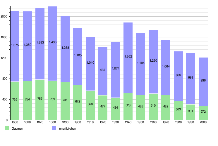
Population Changes Over Time
The chart below shows how the population of Innertkirchen and Gadmen changed over many years:
Important Buildings: Heritage Sites


Two buildings in Innertkirchen are considered very important national heritage sites in Switzerland. These are the Feldhaus Wyler Sunnsiten (an old farmhouse) and the saw mill at Uesers Milital 642 B. They are protected because of their historical value.
Powering the Region: Industry
Innertkirchen has a lot of fast-flowing water from its rivers and streams. This water is used to create electricity! Two hydropower plants here produce a huge amount of power each year (about 1,500 million kWh). These plants also provide jobs for about 220 people, making them a key part of the local economy.
How People Make a Living: Economy

In 2011, the unemployment rate in Innertkirchen was very low, at only 0.65%. This means most people who wanted to work had jobs.
In 2008, about 603 people worked in the municipality. These jobs were in three main areas:
- Primary sector: About 91 people worked in farming or forestry.
- Secondary sector: About 351 people worked in manufacturing (making things) or construction (building things).
- Tertiary sector: About 161 people worked in services, like hotels, restaurants, shops, or healthcare.
Many people who live in Innertkirchen also work there. In 2000, about 55.3% of workers lived and worked in the municipality. Most people used a private car (46.4%) to get to work, while some used public transportation (17.7%).
Beliefs and Churches: Religion

According to the 2000 census, most people in Innertkirchen (about 76.9%) belonged to the Swiss Reformed Church (a type of Protestant church). About 12.3% were Roman Catholic. A smaller number of people belonged to other Christian churches, or were Muslim or Buddhist. Some people did not belong to any church.
Learning and Schools: Education
In Innertkirchen, about 59.5% of adults have finished high school (non-mandatory upper secondary education), and 11.7% have gone on to higher education, like a university or a specialized college.
The schools in the Canton of Bern follow a system where children attend one year of non-required Kindergarten, then six years of Primary school. After that, they go to three years of lower Secondary school, where students are grouped by their abilities. After secondary school, students can continue their education or start an apprenticeship (learning a trade on the job).
During the 2011-2012 school year, 86 students attended schools in Innertkirchen. There was one kindergarten class with 10 students, three primary classes with 50 students, and one lower secondary class with 26 students. Most students lived and went to school in Innertkirchen.
Getting Around: Transportation

Innertkirchen is the end point for a local train line called the Meiringen–Innertkirchen railway. This train connects the village to Meiringen railway station in the nearby town of Meiringen. Innertkirchen has several train stops, including Innertkirchen Grimseltor and Innertkirchen MIB. From Meiringen, you can connect to another train line that goes from Interlaken to Lucerne. There's also a plan to build a new train tunnel, the Grimsel Tunnel, which would allow train travel further south towards Oberwald railway station.
Images for kids
-
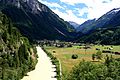
View of Innertkirchen from the river Aare
-
Coat of arms of Innertkirchen
-

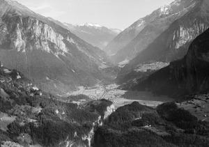
Aerial view of Innertkirchen in 1956
-
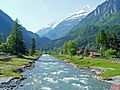
The Aare River and narrow valley at Innertkirchen
-
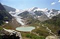
View of Steinsee lake and Gadmen from the Susten Pass
-
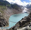
The Trift Glacier and lake in Gadmen
-
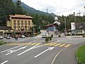
The center of Innertkirchen, at the crossroads between the Susten and Grimsel Passes
-
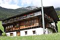
The Feldhaus Wyler Sunnsiten, an old farmhouse
-
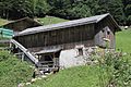
The Saw Mill in the Mühletal valley
-
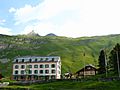
The Hotel Engstlenalp in Innertkirchen
-
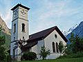
The Reformed church in Innertkirchen
-
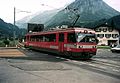
The Meiringen-Innertkirchen Bahn train at Innertkirchen station
See also
 In Spanish: Innertkirchen para niños
