
Lauterbrunnen facts for kids
Quick facts for kids
Lauterbrunnen
|
||
|---|---|---|

Valley of Lauterbrunnen
|
||
|
||

Lauterbrunnen
Location in Switzerland

Lauterbrunnen
Location in Canton of Bern
|
||
| Country | Switzerland | |
| Canton | Bern | |
| District | Interlaken-Oberhasli | |
| Area | ||
| • Total | 164.51 km2 (63.52 sq mi) | |
| Elevation
(Church)
|
802 m (2,631 ft) | |
| Population
(Dec 2020 )
|
||
| • Total | 2,301 | |
| • Density | 13.987/km2 (36.226/sq mi) | |
| Demonym(s) | German: Lautenbrunner/in | |
| Postal code |
3822
|
|
| Localities | Lauterbrunnen, Wengen, Mürren, Gimmelwald, Stechelberg, Isenfluh, Soustal, Sefinental | |
| Surrounded by | Aeschi bei Spiez, Blatten (Lötschen) (VS), Fieschertal (VS), Grindelwald, Gündlischwand, Kandersteg, Lütschental, Reichenbach im Kandertal, Saxeten, Wilderswil | |

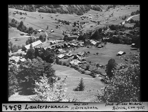
Lauterbrunnen is a village and municipality in Switzerland. It is located in the canton of Bern, within the Interlaken-Oberhasli administrative district. The municipality includes the main village of Lauterbrunnen and other smaller villages. These include Wengen, Mürren, Gimmelwald, Stechelberg, and Isenfluh. The population of Lauterbrunnen village is smaller than Wengen, but larger than the others.
The municipality is home to the beautiful Lauterbrunnen Valley. This valley is at the foot of the Bernese Alps. It is surrounded by famous tall mountains like the Eiger, Mönch, and Jungfrau. The White Lütschine river flows through the valley. This area is part of the Jungfrau Region in the Bernese Oberland. It lies between Interlaken and the main peaks of the Bernese Alps.
Lauterbrunnen is a very popular place for tourists. You can reach it from Interlaken by the Bernese Oberland Railway. It is also the starting point for the Wengernalp Railway, which goes to Kleine Scheidegg. From Kleine Scheidegg, you can take the Jungfrau Railway. This is the highest railway in Europe. It leads to the Jungfrau-Aletsch protected area, a special natural site.
Contents
What's in a Name?
The name Lauterbrunnen was first written down in 1240. Back then, it was called "in claro fonte" in a Romance language. This means "clear spring." By 1253, German speakers called it Liuterbrunnon. The word brunnen definitely means "spring" or "fountain."
However, there is some debate about what lauter means. Some people think it means "clear," "clean," or "bright." This matches the older Romance language name. Others believe it means "many" or "louder." A local idea is that Lauterbrunnen means "many springs." This uses a modern German meaning of lauter. But this might just be a local story, not the true origin.
A Look Back in Time
The oldest sign of people living here is a Roman coin found in Blumental. In the 13th century, the Lauterbrunnen Valley was owned by the Freiherr of Wädenswil. In 1240, he sold the Sefinen Valley to Interlaken Monastery. Over the next 100 years, the monastery gained more control in the valley.
Around 1300, a lord named Turn brought Walser-speaking people to the area. They settled in the nearby Lötschen Valley and the highlands of Lauterbrunnen. By 1346, Walser villages like Lauterbrunnen, Gimmelwald, and Mürren had their own local governments. They had some freedom from the monastery. Later, in 1349, many people in the Bernese Oberland rebelled against the monastery, but they did not succeed. The Walser villages faced the monastery's anger after this.
By the 1400s, the valley's villages were part of a large church area called Gsteig bei Interlaken. Between 1487 and 1488, the people in Lauterbrunnen built their own small church. In 1506, a full-time priest was assigned to Lauterbrunnen. In 1528, the city of Bern adopted the Protestant Reformation. They started to introduce this new faith in the Bernese Oberland. Lauterbrunnen joined other villages in a rebellion against it, but they failed. Bern then took over the monastery's lands. Lauterbrunnen became the center of a new Reformed church area.
Mines were built in the Trachsellauenen area in the late 1500s. They mined iron. In 1715, an iron smelter was built in Zweilütschinen to process the iron ore. Most of the money from the mines went to the rich landowners. The villagers remained poor. In the 1600s and 1700s, many villagers were so poor they joined armies as mercenaries or moved away. Many went to the Carolinas in the United States.
.jpg)
In the late 1700s, mountain climbers from other countries started using Lauterbrunnen as a base. They began their trips into the nearby Alps from here. At first, climbers stayed in the village's church house. As Lauterbrunnen became more famous, more hotels were needed for tourists. A road from Interlaken was finished in 1834. The Bernese Oberland Railway arrived in 1890. This brought even more visitors.
New hotels were built, along with other things for tourists. Cable cars were built to Mürren in 1891 and to Wengen in 1893. The most important project was the Jungfrau railway, built in 1912. This rack railway travels about 9 kilometers (5.6 miles) from Kleine Scheidegg to Jungfraujoch. This is the highest railway station in Europe. The railway runs mostly inside tunnels built into the Eiger and Mönch mountains. There are two stations inside the tunnel where passengers can get off. They can look out through windows built into the mountainside.
In 1909, English brothers Walter and Arnold Lunn helped make skiing, curling, and bobsledding popular in Lauterbrunnen. These winter sports brought new tourists during the winter. This changed the summer-only tourism into a year-round business. Tourism in Lauterbrunnen was badly affected by World War I and World War II, and the Great Depression. But after World War II ended, tourism grew again. Many new vacation homes and chalets were built. Ski lifts, chair lifts, and a heliport were also added.
On January 1, 1973, the village of Isenfluh joined the municipality of Lauterbrunnen. In 2010, Lauterbrunnen became part of the new Verwaltungskreis Interlaken-Oberhasli. In May 2024, local leaders started looking for ways to manage too many tourists. They are thinking about a small entry fee for day visitors who arrive by car. This would not apply to those with hotel bookings or who use public transport.
Amazing Geography

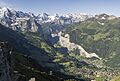
Lauterbrunnen sits at the bottom of a U-shaped valley. This valley stretches south and then southwest from the village. It meets the 8-kilometer (5-mile) long Lauterbrunnen Wall. The Lauterbrunnen Valley (Lauterbrunnental) is one of the deepest valleys in the Alps. This is true when you compare it to the height of the mountains on either side. It is a narrow crack, usually less than one kilometer (0.6 miles) wide. It is surrounded by very steep limestone cliffs, some of which are 1,000 meters (3,280 feet) high.
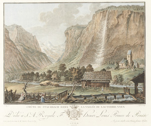
Because of this shape, the valley has many waterfalls, which is how it got its name. Streams flow down from the mountains. When they reach the edge of the valley's rocky walls, they form very high waterfalls. The water often turns into spray before it even reaches the valley floor. The most famous of these is Staubbach Falls. It is less than one kilometer (0.6 miles) from Lauterbrunnen village. The Staubbach is 297 meters (974 feet) high. It is the highest free-falling waterfall in Switzerland.
Also near Lauterbrunnen is the Mürrenbach Fall, which is 417 meters (1,368 feet) high. This is the highest waterfall in Switzerland. The Mattenbachfall is a cascade waterfall. It is 930 meters (3,051 feet) high. This makes it Europe's highest waterfall and the third highest in the world.

The Weisse Lütschine river flows through Lauterbrunnen. It overflows its banks about once a year. The river's water comes from melting snow high in the mountains. This makes it a very pure and clean water source. Trümmelbach Falls is about 3 kilometers (1.9 miles) from Lauterbrunnen. You can get there by bus from the station.
Famous Waterfalls in Lauterbrunnen
- Staubbach Fall
- Trümmelbach Falls
- Mürrenbach Fall
- Spissbach Falls
- Sefinen Fall
- Staldenbach Falls
- Holdri Falls
- Talbach Fall
The valley also has many glaciers, like the Tschingelfirn and the Rottalgletscher. The municipality of Lauterbrunnen stretches far beyond the main village and valley. It reaches the peaks of the Eiger, Mönch, and Jungfrau to the east. To the south, it includes the Gletscherhorn and Breithorn. To the west, it reaches the Schilthorn.
The Kleine Scheidegg Pass connects to Grindelwald in the east. The Sefinenfurgge Pass connects to Griesalp in the west. Both of these passes have hiking trails. These trails are part of the Alpine Pass Route, a long hiking path across Switzerland.
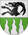
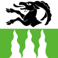
Coat of Arms
The coat of arms for Lauterbrunnen shows a black half-goat climbing on a silver background. Below that, there are three wavy white stripes on a green background. The three wavy stripes represent the three famous waterfalls around the village.
Who Lives Here?


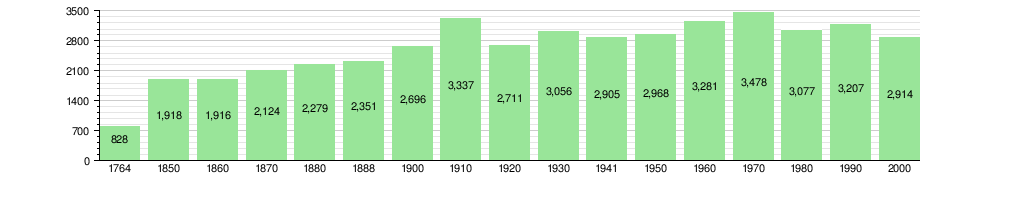
As of December 2010, Lauterbrunnen had a population of 2,558 people. In 2010, about 22.6% of the people living there were foreign nationals. Over ten years (2000–2010), the population decreased by 8.9%.
Most people in Lauterbrunnen speak German as their main language. In 2000, about 85.2% of the population spoke German. Portuguese was the second most common language, spoken by 4.9% of people. Croatian was third, spoken by 2.0%. There were also people who spoke French and Italian.
In 2008, about 49.7% of the population was male and 50.3% was female. Many people born in Lauterbrunnen still live there. Others were born in the same canton or elsewhere in Switzerland. About 18.7% of the population was born outside of Switzerland.
In 2010, children and teenagers (0–19 years old) made up 17.2% of the population. Adults (20–64 years old) made up 62.5%. Seniors (over 64 years old) made up 20.2%.
The historical population is shown in the chart below:
Important Heritage Sites

Some places in Lauterbrunnen are very important for their history and culture. The cableway between Stechelberg and Schilthorn is one such site. The Trachsellauenen silver mine is also important. This mine was active from the Middle Ages to early modern times. Both are listed as Swiss heritage sites of national significance. The village of Gimmelwald and the Kleine Scheidegg area are also special. They are part of the Inventory of Swiss Heritage Sites.
Economy and Jobs
In 2011, Lauterbrunnen had a low unemployment rate of 1.9%. In 2008, there were 1,908 people working in the municipality. Most jobs were in the service sector, like hotels and restaurants. There were 1,538 people working in this sector. About 223 people worked in the secondary sector, which includes construction. About 147 people worked in the primary sector, like agriculture.
In 2008, there were 1,605 full-time jobs. A large number of these jobs, 687, were in hotels or restaurants. This shows how important tourism is to the area. Many people also worked in transportation and storage. In 2000, 360 workers came into Lauterbrunnen for work. 252 workers left to work elsewhere. This means more people come to Lauterbrunnen for jobs than leave. About 12.5% of workers used public transportation. 12.3% used a private car to get to work.
Tourism in Lauterbrunnen
Lauterbrunnen is a very popular place for tourists. It is especially known as a top spot for wingsuit BASE jumping.
Wingsuit BASE Jumping
The Lauterbrunnen Valley is famous for wingsuit BASE jumping. People who love this sport come here from all over the world. The valley has steep rock faces and 13 legal places to jump from. Many consider it a "mecca" for BASE jumpers. About 20,000 jumps happen here each year. This is much more than in the early 2000s. In 2023, 600 BASE jumpers from different countries visited Lauterbrunnen for this extreme sport.
Wingsuit BASE jumping is a very risky sport. Sadly, about three people die here each year on average. The first fatal accident happened in 1994. It took the life of BASE jumper Xaver Bongard. He had brought the sport to the valley in 1989. As of July 2024, 68 BASE jumpers have died in the Lauterbrunnen Valley. In 2021, the church in Lauterbrunnen put up a memorial. It honors BASE jumpers and mountaineers who lost their lives in the valley.
BASE jumping is legal in Switzerland. In Lauterbrunnen, jumpers must buy a landing card from the Swiss BASE Association. However, unlike skydiving, you do not need a license to BASE jump.
Religious Life
Based on the 2000 census, many people in Lauterbrunnen belong to Christian churches. About 17.6% were Roman Catholic. A larger group, 67.7%, belonged to the Swiss Reformed Church. There were also some members of Orthodox churches and other Christian churches. A small number of people were Muslim or Jewish. Some people did not belong to any church.
Climate
Between 1981 and 2010, Lauterbrunnen had about 136.5 days of rain or snow each year. On average, it received 1,207 millimeters (47.5 inches) of precipitation. July was the wettest month. It had an average of 144 millimeters (5.7 inches) of rain or snow over 13.8 days. June had the most days with precipitation, about 14.1 days. However, it received less rain or snow, about 133 millimeters (5.2 inches). October was the driest month. It had an average of 78 millimeters (3.1 inches) of precipitation over 9.5 days.
Getting Around

Lauterbrunnen railway station is in the center of Lauterbrunnen village. Trains from the Berner Oberland Bahn connect it to Interlaken. Trains from the Wengernalpbahn go to Wengen, Kleine Scheidegg, and then to Grindelwald. At Kleine Scheidegg, you can switch to the Jungfraubahn. This train goes up inside the Eiger mountain to the Jungfraujoch.
Next to the main station is the lower part of the Bergbahn Lauterbrunnen-Mürren. This is a cable car and connecting train. It takes you to Mürren. Besides Lauterbrunnen station, there are nine other railway stations in the municipality. These include Wengen, Kleine Scheidegg, and Mürren.
Post buses connect Lauterbrunnen village to Stechelberg and the Trümmelbach Falls. They also go to Isenfluh. Another way to get to Mürren is to take the bus to Stechelberg. From there, you can use the Luftseilbahn Stechelberg-Mürren-Schilthorn cable car.
Education
In Lauterbrunnen, about 39.6% of the people have finished non-mandatory upper secondary education. About 7.9% have completed higher education, like university.
The Canton of Bern school system offers one year of optional kindergarten. After that, there are six years of primary school. Then, students attend three years of required lower secondary school. In lower secondary, students are grouped by their abilities. After lower secondary school, students can continue their education or start an apprenticeship.
During the 2010-2011 school year, 247 students attended classes in Lauterbrunnen. There were 3 kindergarten classes with 36 students. The municipality had 8 primary classes with 125 students. There were also 3 lower secondary classes with 65 students. Some students were permanent or temporary residents of Switzerland. Some had a different first language than the classroom language. The remaining students went to private or special schools.
In 2000, 5 students from Lauterbrunnen went to school in other towns. 45 residents went to schools outside the municipality.
Images for kids
-
Valley of Lauterbrunnen
-
Lauterbrunnen Coat of Arms
-
Lauterbrunnen Flag

See also
 In Spanish: Lauterbrunnen para niños
