
Kandersteg facts for kids
Quick facts for kids
Kandersteg
|
||
|---|---|---|

Kandersteg center with reformed church
|
||
|
||

Kandersteg
Location in Switzerland

Kandersteg
Location in Canton of Bern
|
||
| Country | Switzerland | |
| Canton | Bern | |
| District | Frutigen-Niedersimmental | |
| Area | ||
| • Total | 134.33 km2 (51.87 sq mi) | |
| Elevation | 1,174 m (3,852 ft) | |
| Highest elevation
(Balmhorn)
|
3,698 m (12,133 ft) | |
| Lowest elevation
(Bühl)
|
1,150 m (3,770 ft) | |
| Population
(Dec 2020 )
|
||
| • Total | 1,288 | |
| • Density | 9.588/km2 (24.834/sq mi) | |
| Postal code |
3718
|
|
| Surrounded by | Adelboden, Blatten (Lötschen) (VS), Ferden (VS), Frutigen, Kandergrund, Kippel (VS), Lauterbrunnen, Leukerbad (VS), Reichenbach im Kandertal, Wiler (Lötschen) (VS) | |

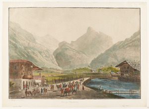
Kandersteg is a small town in Switzerland. It is located in the Bern region, in a beautiful valley. This valley is carved by the Kander River. Kandersteg is famous for its amazing mountain views and pretty alpine scenery.
Today, Tourism is very important to Kandersteg's economy. People visit all year round for outdoor fun. You can enjoy hiking and mountain climbing. In winter, there's downhill and cross-country skiing. Kandersteg even hosted big ski jumping and Nordic combined events for young athletes in 2018.
Contents
Kandersteg's Past
Kandersteg was first mentioned in history in 1352. Back then, it was part of a larger area called der Kandergrund. Long ago, not many people lived here. But some old bows from the Stone Age and a Bronze Age needle were found. This shows people were here thousands of years ago. During the Roman times, a bridge and a road were built in the village.
Churches and Community Growth
Until 1909, Kandersteg was part of Kandergrund for its government and church. A small church was built in Kandersteg in 1511. It survived big changes during the Protestant Reformation in 1530. It became its own parish church in 1910. A Roman Catholic church was also built in 1927.
How Kandersteg Grew
For a long time, people in Kandersteg made a living by moving their animals to different pastures with the seasons. They also traded goods over the mountain passes. In the 1600s and 1700s, people started mining sulfur nearby. A match factory opened in the 1800s because of this sulfur.
Around 1850, Kandersteg started to become a popular place for tourists. Many hotels opened between 1855 and 1890. By 1913, there were 19 hotels! The number of people living here grew a lot when the Lötschberg Tunnel and Lötschberg railway line were built from 1906 to 1913. The new train line made it much easier for tourists to visit.
Later, a chair lift to Oeschinen Lake opened in 1948. A cable car followed in 1951. A ski jump was built in 1979. The famous Kandersteg International Scout Centre also opened here in 1923.
Kandersteg's Geography

.JPG)

Kandersteg is located on the northern side of the Bernese Alps. It sits about 1,200 meters (3,900 ft) above sea level. The village is at the bottom of the Lötschen and Gemmi Passes. The town and its 1200 residents are in the upper Kander Valley. The area of Kandersteg includes the Gastern Valley and the Oeschinen area.
Surrounding Mountains and Valleys
Kandersteg is surrounded by very tall mountains. The Balmhorn is the highest at 3,698 m (12,133 ft). It is on the border with the Valais region. The Blüemlisalp is also very tall at 3,663 m (12,018 ft). It is east of the village. The Gross Lohner is 3,049 m (10,003 ft) high. It stands between the Kander Valley and the Adelboden valley.
Two mountain passes connect Kandersteg to other areas. The Bunderchrinde Pass (2,385 m (7,825 ft)) leads to Adelboden. The Hohtürli Pass (2,778 m (9,114 ft)) goes to Griesalp. These passes do not have roads. They are part of the Alpine Pass Route. This is a long hiking trail across Switzerland.
Lakes and Glaciers
The biggest lake in the valley is lake Oeschinen. It is located at 1,578 m (5,177 ft) east of Kandersteg. It sits at the foot of the Blüemlisalp mountains. The Gastern Valley is a quiet, almost closed-off valley. At the top of this valley is the Kander Glacier. This glacier is where the Kander river begins. The Kander river is 44 km (27 mi) long. The Gastern Valley is also on the way to the 2,700 m (8,900 ft) high Lötschen Pass.
A part of Kandersteg is in the Jungfrau-Aletsch Protected Area. This area is a UNESCO World Heritage Site. It includes Lake Oeschinen and the Gastern Valley.
Kandersteg's People
.JPG)

Kandersteg has a population of about 1231 people. About 18% of the people living here are from other countries. Most people in Kandersteg speak German. Some also speak Portuguese or English.
Population Changes Over Time
The number of people living in Kandersteg has changed over the years.
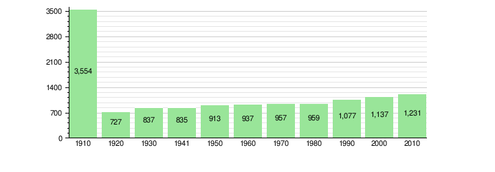
The population grew a lot between 1906 and 1913. This was when the Lötschberg railway line was being built.
Important Buildings

The Gasthof Ruedihaus is a special hotel and restaurant. It is listed as a very important Swiss heritage site. This means it is a building of national importance.
Kandersteg's Economy

Kandersteg has many jobs, especially in tourism. Many people work in hotels, restaurants, and shops. Some people also work in farming and construction. In 2012, about 678 people had jobs in Kandersteg.
Types of Jobs
- Primary sector: This includes jobs like farming. About 44 people work in this area.
- Secondary sector: This includes jobs like manufacturing and construction. About 99 people work here.
- Tertiary sector: This is the biggest sector. It includes jobs in hotels, restaurants, transport, and sales. About 535 people work in this area.
Religion in Kandersteg

Most people in Kandersteg belong to the Swiss Reformed Church. About 74% of the population are members. Around 13.5% are Roman Catholic. A smaller number of people belong to other Christian churches or are Islamic. Some people do not belong to any church.
Learning in Kandersteg
In Kandersteg, many adults have finished high school. Some have also gone on to college or university.
School System
The schools in the Canton of Bern follow a specific system:
- One year of non-required Kindergarten.
- Six years of primary school.
- Three years of lower secondary school. Students are grouped by their abilities.
After secondary school, students can continue their education or start an apprenticeship.
In the 2010-2011 school year, 86 students went to school in Kandersteg. There was one kindergarten class with 18 students. There were three primary classes with 68 students.
Fun Things to Do in Kandersteg
.jpg)
Kandersteg has many places to stay, from fancy hotels to holiday apartments and camp sites. The World Scout Centre is located here. Over 14,000 Scouts from all over the world visit it every year! There are also mountain huts for hikers.
Hiking and Climbing

The Kander Valley has many hiking trails. You can hike from the valley floor up to the mountain tops and passes. Some famous trails go to the Valais region. You can cross the Gemmi Pass to Leukerbad. Or you can go through the wild Gastern valley and over the Lötschen Pass to the Lötschental.
Lakes and Cable Cars
Lake Oeschinen is one of the most beautiful lakes in Switzerland. You can reach it by the Kandersteg-Oeschinen cable car. Other cable cars take you to the Sunnbüel and Allmenalp areas.
Winter Activities
In winter, Kandersteg is great for cross-country skiing. There are over 50 kilometers (31 mi) of trails. There are also small downhill ski areas near Lake Oeschinen and Sunnbüel. You can also enjoy skating, curling, ice climbing, and ice fishing.
Other Attractions
Near Kandersteg, you can visit the Ricola Alpine garden. In the village, you can see a church from the 1500s.
Getting Around Kandersteg

Kandersteg is easy to reach because of its good transport links. It is at the northern end of the Lötschberg Tunnel. This tunnel is part of the Lötschberg railway line, a major train line across the Alps.
Train and Car Shuttle
Kandersteg railway station is in the village. It's the first station north of the tunnel. Trains travel 15 kilometres (9.3 mi) through the tunnel to Goppenstein in Valais. You can even put your car on a special train to go through the tunnel!
Since 2007, a new, faster tunnel called the Lötschberg Base Tunnel connects Frutigen with Raron. This means the old Lötschberg line is used less for passenger trains. But hourly trains still run between Bern and Brig. Freight trains also still use the mountain railway.
Bus Services
Buses also serve the area. PostAuto buses go down the Kandertal to places like Mitholz and Frutigen. They also go up the Gastertal to Selden.
See also
 In Spanish: Kandersteg para niños
