
Kandergrund facts for kids
Quick facts for kids
Kandergrund
|
||
|---|---|---|

Kandergrund village
|
||
|
||

Kandergrund
Location in Switzerland

Kandergrund
Location in Canton of Bern
|
||
| Country | Switzerland | |
| Canton | Bern | |
| District | Frutigen-Niedersimmental | |
| Area | ||
| • Total | 32.09 km2 (12.39 sq mi) | |
| Elevation | 800 m (2,600 ft) | |
| Population
(Dec 2020 )
|
||
| • Total | 807 | |
| • Density | 25.148/km2 (65.13/sq mi) | |
| Postal code |
3716
|
|
| Surrounded by | Frutigen, Kandersteg, Reichenbach im Kandertal | |

Kandergrund is a small town, also called a municipality, located in the Frutigen-Niedersimmental administrative district in the canton of Bern in Switzerland. It's a beautiful place nestled in the Swiss Alps.
Contents
History of Kandergrund
Early Settlements and Beginnings
People might have lived in the Kandergrund area as early as the Bronze Age. However, the first recorded settlement was near a castle called Felsenburg. Today, only ruins of this castle remain. Kandergrund was first mentioned in official papers in 1352. At that time, it was known as der Kandergrund, and it included the nearby town of Kandersteg.
Becoming an Independent Municipality
During the Middle Ages, Kandergrund was part of Frutigen for both its government and religious life. In 1850, Kandergrund became its own independent municipality. It included several smaller areas like Ausserrüteni, Innerrüteni, Kandergrund, Mitholz, Kandersteg, and Gastern.
A church was built in Bunderbach in 1850. Ten years later, this church became the main church for the Kandergrund area. In 1909, Kandersteg separated from Kandergrund to become its own municipality.
Growth from Railway Construction
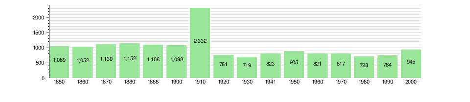
The population of Kandergrund grew a lot between 1906 and 1913. This was because many people came to work on the construction of the Lötschberg Tunnel and the Lötschberg railway line. These projects were very important for connecting different parts of Switzerland.
Geography of Kandergrund

Kandergrund covers an area of about 32.1 square kilometers (about 12.4 square miles). A large part of this land is used for farming, about 32.8%. Forests cover an even bigger part, about 36.9% of the area.
Land Use and Natural Features
About 4.3% of Kandergrund's land is used for buildings and roads. A small amount, 0.8%, is covered by rivers or lakes. The remaining 25.2% is land that cannot be used for farming or building, like rocky areas.
Most of the forests are dense, covering 32.4% of the total land. The rest of the forested land has orchards or small groups of trees. For farming, 10.9% is used for pastures, and 21.9% is for alpine pastures, which are high mountain meadows. All the water in Kandergrund is flowing water, like rivers and streams.
Location and Districts
Kandergrund is located in the upper part of the Kander river valley. It is made up of several smaller communities called Bäuerten. These include Ausser Kandergrund, Inner-Kandergrund, Bunderbach, Mitholz, Reckental, and Rüti.
In 2010, Kandergrund became part of a new administrative district. This new district is called Verwaltungskreis Frutigen-Niedersimmental.
Kandergrund's Coat of Arms
A coat of arms is a special design that represents a town or family. Kandergrund's coat of arms is green with three wavy silver stripes. These stripes are outlined in black. The wavy stripes likely represent the Kander river that flows through the valley.
Population and People
Kandergrund has a population of about 809 people, as of December 2010. About 5.7% of the people living in Kandergrund are from other countries. Over the past ten years, the population has changed a bit.
Languages Spoken
Most people in Kandergrund speak German. About 91.9% of the population speaks German as their main language. Swedish is the second most common language, spoken by about 3.3% of the people. Italian is spoken by about 1.5% of the population. A few people also speak French.
Age Groups and Families
As of 2010, about 19.7% of the population are children and teenagers (under 20 years old). Adults (20 to 64 years old) make up 63% of the population. Seniors (over 64 years old) make up 17.3%.
In 2000, there were 85 homes where only one person lived. There were also 26 homes with five or more people living together.
Population Changes Over Time
The chart below shows how Kandergrund's population has changed throughout history:
Important Historical Sites
Felsenburg Castle Ruins
The ruins of Felsenburg Castle are a very important historical site in Switzerland. It is listed as a heritage site of national significance.
The castle was built in the 12th century, which is a very long time ago! However, it was left empty by the year 1400 and slowly fell into ruins. Today, you can still see parts of the tower and some of the old walls. It's a cool place to imagine what life was like hundreds of years ago.
Economy and Jobs
In 2011, Kandergrund had a very low unemployment rate, meaning almost everyone who wanted a job had one. In 2008, there were 284 people working in the municipality.
Main Job Types
Jobs in Kandergrund are divided into three main types:
- Primary sector: This includes jobs related to nature, like farming, forestry, and fishing. About 130 people worked in this sector.
- Secondary sector: These jobs involve making things, like in factories or construction. About 59 people worked in this sector.
- Tertiary sector: These jobs provide services to people, like working in shops, restaurants, or schools. About 95 people worked in this sector.
Many people who live in Kandergrund travel to other towns for work. In 2000, 219 people left Kandergrund for work, while 100 people came into Kandergrund to work. About 39.7% of working people used public transportation to get to their jobs, and 37.8% used a private car.
Transportation in Kandergrund
The Lötschberg railway line passes through Kandergrund. However, there are no train stations directly in the municipality. The closest train stations are Kandersteg station to the south and Frutigen station to the north.
To get around, Kandergrund has a PostAuto bus service. This bus connects the municipality to both the Kandersteg and Frutigen train stations, making it easy for people to travel.
Religion in Kandergrund
Based on information from 2000, most people in Kandergrund belong to a Christian church.
- About 64.9% of the population belonged to the Swiss Reformed Church.
- About 8.5% were Roman Catholic.
- A smaller number of people belonged to other Christian churches.
- About 2.22% of the population were Islamic.
- A very small number of people were Buddhist.
- About 18.10% of the population did not belong to any church or had no specific religion.
Education in Kandergrund
In Kandergrund, about 40.4% of the population has finished upper secondary education. This is schooling after primary school that is not mandatory. About 3.9% of people have gone on to higher education, like university.
School System in Bern Canton
The school system in the Canton of Bern, where Kandergrund is located, works like this:
- There is one year of non-mandatory Kindergarten.
- Then, students attend six years of Primary school.
- After primary school, there are three years of mandatory lower Secondary school. In this stage, students are grouped based on their abilities.
- After lower Secondary school, students can choose to continue their education or start an apprenticeship, where they learn a trade while working.
During the 2010–11 school year, 79 students attended classes in Kandergrund. There was one kindergarten class with 14 students. The municipality had two primary classes with 46 students. There was also one lower secondary class with 19 students.
In 2000, 31 students from Kandergrund went to schools outside of the municipality.
See also
 In Spanish: Kandergrund para niños
