
Frutigen facts for kids
Quick facts for kids
Frutigen
|
||
|---|---|---|
 |
||
|
||

Frutigen
Location in Switzerland

Frutigen
Location in Canton of Bern
|
||
| Country | Switzerland | |
| Canton | Bern | |
| District | Frutigen-Niedersimmental | |
| Area | ||
| • Total | 72.28 km2 (27.91 sq mi) | |
| Elevation | 800 m (2,600 ft) | |
| Population
(Dec 2020 )
|
||
| • Total | 6,967 | |
| • Density | 96.389/km2 (249.65/sq mi) | |
| Postal code |
3714
|
|
| Surrounded by | Adelboden, Diemtigen, Kandergrund, Kandersteg, Reichenbach im Kandertal | |
| Twin towns | Teteven (Bulgaria) | |

Frutigen is a town in the Bernese Oberland area of Switzerland. It is located in the canton of Bern. Frutigen is also the main town of the Frutigen-Niedersimmental administrative district.
Contents
- Frutigen's Past: A Look at History
- Frutigen's Natural Surroundings: Geography
- Frutigen's Symbol: Coat of Arms
- People of Frutigen: Demographics
- Places to See: Sights
- How Frutigen Makes Money: Economy
- Getting Around: Transport
- Beliefs and Faith: Religion
- Weather Patterns: Climate
- Learning and Schools: Education
- Local Delights: Cuisine
- See also
Frutigen's Past: A Look at History


People might have lived in the Frutigen area since the Bronze Age or Roman times. The town was first officially mentioned in the year 1234 as Frutingen.
During the Middle Ages, there were three castles here. These were Halten, Tellenburg, and Bürg castles. Around 1260, the farmers in the valley joined together. They formed a group to help each other with politics and business. This group even had its own seal by 1263. In 1340, they made a peace agreement with a group from a nearby valley.
In 1391, the village of Frutigen gained the right to have its own local court. By 1400, the city-state of Bern took over the whole valley. However, the local group was strong. They made Bern give them special rights. The people of the valley did not have to pay taxes to local lords. Their soldiers could also march under their own banner. These special freedoms lasted until 1854.
Churches and Religious Changes
The village church, Saint Quirinus' church, was first mentioned in 1228. It was one of twelve churches around Lake Thun. This church was built on top of an even older church. The very first church was likely built in the 700s or 800s. It was built over tombs from the 600s or 700s.
The original church was replaced in the 1000s or 1100s. That church was rebuilt in 1421. The church you see today was built in 1727. It was built after a fire destroyed the 1421 church. In 1528, Bern became Protestant. It tried to make everyone in the canton Protestant too. Frutigen, like other areas, resisted this new faith. But they adopted it after a local uprising was stopped.
The large church area of Frutigen was divided over time. But it still includes Schwandi and Wengi villages. These are part of the Reichenbach municipality. A Roman Catholic church was built in Frutigen in 1959. This Catholic church covers about the same area as the old medieval church.
Trade and Economic Growth
The valley always benefited from trade. Goods passed through the Gemmi and Lötschen Passes. A special warehouse and resting place for travelers was built in Kanderbrück in the 1500s. Similar buildings had existed since the Middle Ages.
In the 1500s, the local economy started to change. Farmers began to focus on raising cattle for export. They stopped growing many different crops. This meant the village had to buy grain from other parts of Switzerland. Around 1850, the economy changed again. Factories making lace and watches moved into the valley. A matchstick factory also opened in Frutigen in 1850.
Modern Transportation Links
The first mail coach service to Frutigen started in 1814. It connected Frutigen to Thun. The Spiez-Frutigen railway opened in 1901. Then, the Bern–Lötschberg–Simplon railway opened in 1913. In 1917, the Postauto (a bus service) started regular routes. These connected Frutigen to Adelboden. The railway and better roads helped industries and tourism grow in Frutigen.
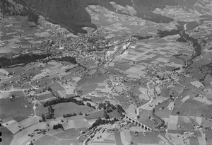
Frutigen's Natural Surroundings: Geography

Frutigen covers an area of about 71.8 square kilometers (27.7 square miles). More than half of this land, about 53.5%, is used for farming. Forests cover about 26.6% of the area. Buildings and roads make up about 4.6% of the land. Rivers and lakes cover about 1.2%. The remaining 14.2% is land that cannot be used for farming or building.
Most of the built-up area is for houses and other buildings (1.9%). Roads and other transport areas make up 1.6%. In the forested areas, 21.8% is dense forest. Another 3.3% has orchards or small groups of trees. For farming, 16.9% is used for pastures. A larger part, 36.5%, is used for alpine pastures (high mountain grazing). All the water in Frutigen is flowing water, like rivers.
Frutigen is located in the valleys of the Kander and Engstligen rivers. It sits between the Niesenkette and Gehrihorn mountains. The municipality includes several villages. These are Frutigen, Kanderbrück, Hasli, Innerschwandi, Ladholz, Oberfeld-Prasten, Reinisch, and Winklen. There are also many individual farms scattered across the valley and up the mountainsides. Some farms are as high as 1,600 meters (5,200 feet) above sea level.
In 2010, Frutigen became part of a new administrative area. This new area is called Verwaltungskreis Frutigen-Niedersimmental.
Frutigen's Symbol: Coat of Arms
The blazon (description) of Frutigen's coat of arms is simple. It shows a black eagle with its wings spread out. The eagle has a gold crown, beak, tongue, and claws. All of this is set on a silver background.
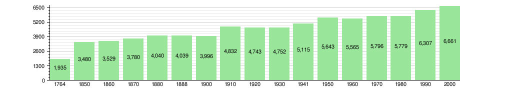
People of Frutigen: Demographics


Frutigen has a population of about 6,718 people (as of December 2010). About 6.2% of the people living here are foreign nationals. Over the last ten years (2000–2010), the population has stayed about the same. A small number of people moved in (0.5%). More people were born than died (1.1%).
Most people in Frutigen speak German as their first language (96.1%). Albanian is the second most common language (0.9%). French is the third (0.5%).
In 2008, about 48% of the population was male and 52% was female. Most people (57.4%) were born in Frutigen and still lived there in 2000. About 24.3% were born in the same canton (Bern). About 8% were born elsewhere in Switzerland. And 6.8% were born outside of Switzerland.
In 2010, children and teenagers (0–19 years old) made up 23.8% of the population. Adults (20–64 years old) made up 59.2%. Seniors (over 64 years old) made up 17%.
The chart below shows how Frutigen's population has changed over time:
Places to See: Sights
The small village of Kanderbrück and the Rybrügg / Hasli area are special. They are part of the Inventory of Swiss Heritage Sites. This means they are important historical places in Switzerland.
How Frutigen Makes Money: Economy

Today, Frutigen's economy focuses on a few main things. These include the hydraulics industry (which uses liquids to create power), slate mining, and tourism.
Frutigen is at the northern end of the Lötschberg Base Tunnel. This tunnel uses geothermal energy (heat from the Earth). This energy powers the Tropenhaus Frutigen. This is a special tropical greenhouse. It grows exotic fruits and raises sturgeon fish for meat and caviar.
In 2011, Frutigen had a very low unemployment rate of 0.99%. In 2008, about 3,628 people worked in Frutigen.
- About 648 people worked in the primary sector. This means jobs like farming and fishing.
- About 1,324 people worked in the secondary sector. This includes jobs in manufacturing and construction.
- About 1,656 people worked in the tertiary sector. These are service jobs, like in shops, transport, or healthcare.
Many people who live in Frutigen also work there. In 2000, 888 workers came into Frutigen for work. But 1,124 workers left Frutigen to work somewhere else. This means more people leave Frutigen for work than come in. About 12.4% of working people used public transport. About 47.7% used a private car to get to work.
Getting Around: Transport
Frutigen railway station is right next to the village. It is on the Lötschberg line. Trains from here go to Bern, Thun, and Brig. Frutigen also has PostAuto bus services. These buses connect the railway station to nearby villages like Wengi, Reudlen, Reichenbach im Kandertal, Kandergrund, Blausee, Mitholz, Kandersteg, Achseten, and Adelboden.
Beliefs and Faith: Religion


Based on a 2000 survey:
- About 6% of people were Roman Catholic.
- About 68.8% belonged to the Swiss Reformed Church (a Protestant church).
- A small number of people belonged to other Christian churches (about 28.31%).
- About 2.03% of the population was Islamic.
- A small percentage of people belonged to other religions like Buddhist or Hindu.
- About 3.47% of people said they did not belong to any church.
Weather Patterns: Climate
Between 1981 and 2010, Frutigen had rain or snow on about 136.8 days each year. On average, it received about 1237 millimeters (48.7 inches) of precipitation.
July was the wettest month. Frutigen received about 148 millimeters (5.8 inches) of rain or snow in July. It rained or snowed for about 13 days in July. June had the most days with precipitation (14.1 days), but with slightly less rain or snow (138 millimeters or 5.4 inches). February was the driest month. It received about 79 millimeters (3.1 inches) of precipitation over 9.4 days.
Learning and Schools: Education
In Frutigen, about 36.4% of the population has finished non-mandatory upper secondary education. This means they went to school beyond what is required. About 6.7% have completed higher education. This includes going to a university or a specialized college.
The Canton of Bern school system works like this:
- One year of optional Kindergarten.
- Six years of Primary school.
- Three years of required lower Secondary school. Students are grouped by their abilities.
After lower Secondary, students can continue their schooling or start an apprenticeship (learning a trade on the job).
During the 2010-2011 school year, 873 students attended classes in Frutigen. There were 8 kindergarten classes with 116 students. There were 22 primary classes with 445 students. And there were 19 lower secondary classes with 288 students.
Frutigen has a public library called Gemeindebibliothek Frutigen. In 2008, it had 6,983 books and other media. It loaned out 23,631 items that year. The library was open 253 days, for about 12 hours per week.
Local Delights: Cuisine
Blue cake is a special local pastry that is made in Frutigen.
See also
 In Spanish: Frutigen para niños
