
Matsumoto, Nagano facts for kids
Quick facts for kids
Matsumoto
松本市
|
|||||||||||
|---|---|---|---|---|---|---|---|---|---|---|---|

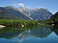
From top (left to right): Matsumoto Castle, A heritage building of Kaichi School, A view of Kamikōchi, Mount Yake and Azusa creek, Nawate souvenir shopping street, A street view of Asama Spa.
|
|||||||||||
|
|||||||||||
 |
|||||||||||

Matsumoto
Location in Japan
|
|||||||||||
| Country | Japan | ||||||||||
| Region | Chūbu (Kōshin'etsu) | ||||||||||
| Prefecture | Nagano Prefecture | ||||||||||
| First official recorded | 4th century | ||||||||||
| City settled | May 1, 1907 | ||||||||||
| Area | |||||||||||
| • Total | 978.47 km2 (377.79 sq mi) | ||||||||||
| Population
(March 1, 2019)
|
|||||||||||
| • Total | 239,466 | ||||||||||
| • Density | 244.7351/km2 (633.861/sq mi) | ||||||||||
| Time zone | UTC+9 (Japan Standard Time) | ||||||||||
| Phone number | 0263-34-3000 | ||||||||||
| Address | 3–7 Marunouchi, Matsumoto-shi, Nagano-ken 390-8620 | ||||||||||
| Climate | Cfa/Dfa | ||||||||||
|
|||||||||||


Matsumoto (松本市 (Matsumoto-shi)) is a city in Nagano Prefecture, Japan. It's known for its beautiful mountain views. Since April 1, 2021, Matsumoto has been a special "core city" in Japan. This means it has more local control over its own affairs.
As of March 1, 2019, about 239,466 people lived in Matsumoto. The city covers an area of about 978.47 square kilometers (377.79 sq mi).
Contents
History of Matsumoto City
Matsumoto has a long history. It was an important place in the Shinano Province during ancient times. The area grew into a castle town around Matsumoto Castle during the Edo period (1603-1868).
Modern Matsumoto Town officially started on April 1, 1889. It became a full city on May 1, 1907. Over the years, Matsumoto grew by adding nearby villages and hamlets. This helped the city expand its area and population.
On November 1, 2000, Matsumoto was named a "special city." This gave it more independence in how it was governed. Later, on April 1, 2021, it became a "core city," which gave it even more local power.
Geography and Nature
Matsumoto is in the middle of Nagano Prefecture. It sits in the Matsumoto Basin, surrounded by tall mountains. People love the amazing views here!
The city is about 75 kilometers (47 mi) south of Nagano City, the capital of the prefecture. It's also about 167 kilometers (104 mi) from central Tokyo. To the west, you can see the huge 3000-meter (9,800 ft) Hida Mountains. The highest point in Matsumoto is Mount Hotakadake, which is 3190 meters (10,470 ft) tall.
Neighboring Towns and Cities
Matsumoto shares its borders with several other places:
- Nagano Prefecture:
- Okaya
- Shiojiri
- Azumino
- Yamagata
- Asahi
- Ōmachi
- Chikuhoku
- Ueda
- Nagawa
- Aoki
- Shimosuwa
- Kiso-mura
- Kiso-machi
- Gifu Prefecture:
- Takayama
Climate and Weather
Matsumoto has a climate with hot summers and cold winters. It gets a good amount of rain, especially in summer. Winters are usually drier.
The average temperature in Matsumoto for the whole year is about 12.2°C (54.0°F). September is the wettest month, with an average of 148.0 mm (5.83 in) of rain. August is the warmest month, with temperatures around 25.1°C (77.2°F). January is the coldest, averaging about -0.3°C (31.5°F).
| Climate data for Matsumoto (1991–2020 normals, extremes 1898–present, elevation 610m) | |||||||||||||
|---|---|---|---|---|---|---|---|---|---|---|---|---|---|
| Month | Jan | Feb | Mar | Apr | May | Jun | Jul | Aug | Sep | Oct | Nov | Dec | Year |
| Record high °C (°F) | 18.8 (65.8) |
21.1 (70.0) |
25.9 (78.6) |
30.9 (87.6) |
33.6 (92.5) |
35.9 (96.6) |
37.9 (100.2) |
38.5 (101.3) |
36.1 (97.0) |
31.8 (89.2) |
25.6 (78.1) |
21.5 (70.7) |
38.5 (101.3) |
| Mean daily maximum °C (°F) | 5.1 (41.2) |
6.6 (43.9) |
11.2 (52.2) |
17.9 (64.2) |
23.6 (74.5) |
26.4 (79.5) |
30.0 (86.0) |
31.4 (88.5) |
26.2 (79.2) |
19.8 (67.6) |
13.9 (57.0) |
8.0 (46.4) |
18.4 (65.1) |
| Daily mean °C (°F) | −0.3 (31.5) |
0.6 (33.1) |
4.6 (40.3) |
10.8 (51.4) |
16.5 (61.7) |
20.2 (68.4) |
24.2 (75.6) |
25.1 (77.2) |
20.4 (68.7) |
13.9 (57.0) |
7.8 (46.0) |
2.5 (36.5) |
12.2 (54.0) |
| Mean daily minimum °C (°F) | −4.9 (23.2) |
−4.5 (23.9) |
−1.0 (30.2) |
4.4 (39.9) |
10.4 (50.7) |
15.4 (59.7) |
19.8 (67.6) |
20.5 (68.9) |
16.2 (61.2) |
9.2 (48.6) |
2.6 (36.7) |
−2.2 (28.0) |
7.2 (45.0) |
| Record low °C (°F) | −24.8 (−12.6) |
−20.4 (−4.7) |
−17.9 (−0.2) |
−10.1 (13.8) |
−2.7 (27.1) |
2.3 (36.1) |
10.2 (50.4) |
8.0 (46.4) |
3.0 (37.4) |
−3.6 (25.5) |
−8.4 (16.9) |
−19.2 (−2.6) |
−24.8 (−12.6) |
| Average precipitation mm (inches) | 39.8 (1.57) |
38.5 (1.52) |
78.0 (3.07) |
81.1 (3.19) |
94.5 (3.72) |
114.9 (4.52) |
131.3 (5.17) |
101.6 (4.00) |
148.0 (5.83) |
128.3 (5.05) |
56.3 (2.22) |
32.7 (1.29) |
1,045.1 (41.15) |
| Average snowfall cm (inches) | 33 (13) |
22 (8.7) |
12 (4.7) |
1 (0.4) |
0 (0) |
0 (0) |
0 (0) |
0 (0) |
0 (0) |
0 (0) |
0 (0) |
8 (3.1) |
76 (30) |
| Average precipitation days (≥ 0.5 mm) | 6.0 | 6.1 | 9.0 | 9.1 | 9.1 | 11.3 | 13.0 | 10.3 | 10.6 | 9.2 | 6.5 | 6.6 | 106.9 |
| Average snowy days | 16.2 | 13.3 | 11.1 | 0 | 0 | 0.0 | 0.0 | 0.0 | 0.0 | 0.1 | 2.6 | 12.0 | 76 |
| Average relative humidity (%) | 67 | 64 | 62 | 58 | 60 | 69 | 71 | 70 | 74 | 75 | 71 | 69 | 68 |
| Mean monthly sunshine hours | 172.5 | 171.2 | 190.9 | 204.8 | 215.6 | 166.3 | 174.8 | 202.9 | 151.0 | 160.9 | 163.0 | 160.9 | 2,134.7 |
| Source: Japan Meteorological Agency | |||||||||||||
| Climate data for Nagawa, Matsumoto (1991–2020 normals, extremes 1978–present) | |||||||||||||
|---|---|---|---|---|---|---|---|---|---|---|---|---|---|
| Month | Jan | Feb | Mar | Apr | May | Jun | Jul | Aug | Sep | Oct | Nov | Dec | Year |
| Record high °C (°F) | 12.4 (54.3) |
16.5 (61.7) |
21.4 (70.5) |
27.5 (81.5) |
30.1 (86.2) |
31.5 (88.7) |
33.1 (91.6) |
34.4 (93.9) |
32.3 (90.1) |
27.5 (81.5) |
21.8 (71.2) |
17.3 (63.1) |
34.4 (93.9) |
| Mean daily maximum °C (°F) | 1.6 (34.9) |
2.9 (37.2) |
7.2 (45.0) |
14.2 (57.6) |
19.9 (67.8) |
22.8 (73.0) |
26.3 (79.3) |
27.5 (81.5) |
22.9 (73.2) |
17.1 (62.8) |
11.2 (52.2) |
4.7 (40.5) |
14.9 (58.8) |
| Daily mean °C (°F) | −3.5 (25.7) |
−2.9 (26.8) |
1.0 (33.8) |
7.0 (44.6) |
12.5 (54.5) |
16.3 (61.3) |
20.1 (68.2) |
20.7 (69.3) |
16.5 (61.7) |
10.2 (50.4) |
4.6 (40.3) |
−0.6 (30.9) |
8.5 (47.3) |
| Mean daily minimum °C (°F) | −8.9 (16.0) |
−9.0 (15.8) |
−4.9 (23.2) |
0.2 (32.4) |
5.4 (41.7) |
10.8 (51.4) |
15.3 (59.5) |
15.8 (60.4) |
11.8 (53.2) |
4.9 (40.8) |
−0.9 (30.4) |
−5.6 (21.9) |
2.9 (37.2) |
| Record low °C (°F) | −20.4 (−4.7) |
−20.9 (−5.6) |
−17.4 (0.7) |
−13.0 (8.6) |
−4.5 (23.9) |
0.3 (32.5) |
6.6 (43.9) |
6.2 (43.2) |
−1.3 (29.7) |
−5.7 (21.7) |
−11.6 (11.1) |
−17.8 (0.0) |
−20.9 (−5.6) |
| Average precipitation mm (inches) | 81.4 (3.20) |
92.7 (3.65) |
149.9 (5.90) |
151.6 (5.97) |
180.2 (7.09) |
221.3 (8.71) |
272.0 (10.71) |
162.5 (6.40) |
242.6 (9.55) |
188.0 (7.40) |
119.7 (4.71) |
84.9 (3.34) |
1,946.8 (76.65) |
| Average precipitation days (≥ 1.0 mm) | 11.6 | 10.6 | 12.6 | 12.0 | 12.2 | 14.2 | 16.3 | 12.2 | 12.6 | 11.1 | 10.0 | 12.2 | 147.6 |
| Mean monthly sunshine hours | 108.7 | 127.1 | 157.4 | 174.9 | 195.6 | 148.4 | 152.0 | 176.8 | 140.6 | 147.9 | 125.7 | 105.1 | 1,759.5 |
| Source: Japan Meteorological Agency | |||||||||||||
| Climate data for Matsumoto Airport, Matsumoto (2003–2020 normals, extremes 2003–present) | |||||||||||||
|---|---|---|---|---|---|---|---|---|---|---|---|---|---|
| Month | Jan | Feb | Mar | Apr | May | Jun | Jul | Aug | Sep | Oct | Nov | Dec | Year |
| Record high °C (°F) | 15.5 (59.9) |
19.2 (66.6) |
24.5 (76.1) |
29.0 (84.2) |
32.2 (90.0) |
33.7 (92.7) |
35.2 (95.4) |
36.6 (97.9) |
35.2 (95.4) |
28.9 (84.0) |
23.1 (73.6) |
20.0 (68.0) |
36.6 (97.9) |
| Mean daily maximum °C (°F) | 4.0 (39.2) |
5.9 (42.6) |
10.5 (50.9) |
16.9 (62.4) |
22.6 (72.7) |
25.7 (78.3) |
28.7 (83.7) |
30.5 (86.9) |
25.6 (78.1) |
19.0 (66.2) |
13.1 (55.6) |
7.2 (45.0) |
17.5 (63.5) |
| Daily mean °C (°F) | −1.4 (29.5) |
0.0 (32.0) |
3.9 (39.0) |
9.8 (49.6) |
15.7 (60.3) |
19.6 (67.3) |
23.2 (73.8) |
24.3 (75.7) |
19.9 (67.8) |
13.4 (56.1) |
7.1 (44.8) |
1.7 (35.1) |
11.4 (52.6) |
| Mean daily minimum °C (°F) | −7.3 (18.9) |
−6.1 (21.0) |
−2.5 (27.5) |
2.7 (36.9) |
8.8 (47.8) |
14.2 (57.6) |
18.9 (66.0) |
19.6 (67.3) |
15.3 (59.5) |
8.2 (46.8) |
1.3 (34.3) |
−4.0 (24.8) |
5.8 (42.4) |
| Record low °C (°F) | −17.2 (1.0) |
−17.9 (−0.2) |
−11.9 (10.6) |
−8.8 (16.2) |
−2.4 (27.7) |
3.2 (37.8) |
11.9 (53.4) |
9.8 (49.6) |
4.5 (40.1) |
−3.2 (26.2) |
−9.2 (15.4) |
−13.7 (7.3) |
−17.9 (−0.2) |
| Average precipitation mm (inches) | 34.6 (1.36) |
41.2 (1.62) |
79.8 (3.14) |
90.6 (3.57) |
103.0 (4.06) |
113.9 (4.48) |
147.4 (5.80) |
98.3 (3.87) |
143.2 (5.64) |
151.0 (5.94) |
59.7 (2.35) |
39.6 (1.56) |
1,102.2 (43.39) |
| Average precipitation days (≥ 1.0 mm) | 4.9 | 5.6 | 7.5 | 9.0 | 8.4 | 10.1 | 12.5 | 9.9 | 9.4 | 8.1 | 5.9 | 5.3 | 96.6 |
| Source: Japan Meteorological Agency | |||||||||||||
Population Growth in Matsumoto
The number of people living in Matsumoto has grown a lot over time. Recently, the population has stayed about the same after a long period of growth.
| Historical population | ||
|---|---|---|
| Year | Pop. | ±% |
| 1940 | 154,182 | — |
| 1950 | 183,775 | +19.2% |
| 1960 | 190,076 | +3.4% |
| 1970 | 203,571 | +7.1% |
| 1980 | 223,496 | +9.8% |
| 1990 | 233,756 | +4.6% |
| 2000 | 243,465 | +4.2% |
| 2010 | 243,070 | −0.2% |
| 2020 | 241,145 | −0.8% |
Economy and Local Products
Matsumoto is an important business hub for its region. It's known for traditional crafts like woodworking and silk spinning. The city also produces electronics and has a strong dairy industry.
Many tourists visit Matsumoto to see the mountains and enjoy the onsen (hot spring resorts). Tourism is a big part of the local economy.
Education in Matsumoto
Matsumoto has many schools and colleges for students of all ages.
Universities and Colleges
- Shinshu University
- Matsumoto University
- Matsusho Gakuen Junior College
- Matsumoto Junior College
Elementary and High Schools
The city has 29 public elementary schools and 19 public middle schools. There are also private schools and one school run by the national government. For older students, Matsumoto has seven public high schools and six private high schools. There is also a special school called Nagano Korean Elementary and Junior High School.
A very old school, Kaichi School, opened in 1876. Farmers helped pay for 70% of its building costs. It was one of the first modern schools in Japan. Today, it's a museum.
Transportation Around the City
Matsumoto has different ways to travel in and out of the city.
Airport
- Matsumoto Airport
Railway Lines
You can travel by train using these lines:
 East Japan Railway Company – Shinonoi Line
- Murai – Hirata – Minami-Matsumoto – Matsumoto
- East Japan Railway Company – Ōito Line
- Matsumoto – Kita-Matsumoto – Shimauchi – Shimatakamatsu
- Alpico Kōtsū – Kamikōchi Line
- Matsumoto – Nishi-Matsumoto – Nagisa – Shinano-Arai – Ōniwa – Shimonii – Kitanii-Matsumotodaigakumae – Niimura – Samizo – Moriguchi – Shimojima – Hata – Endō – Shin-Shimashima
Major Highways
Main roads that pass through Matsumoto include:
 Nagano Expressway
 National Route 19
 National Route 143
 National Route 147
 National Route 158
 National Route 254
 National Route 403
Sister City Connections
Matsumoto has special partnerships with other cities, both in Japan and around the world. These are called "sister city" relationships.
In Japan
- Fujisawa, Kanagawa, since July 29, 1961
- Himeji, Hyōgo, since November 17, 1966
- Takayama, Gifu, since November 1, 1971
Around the World
 Salt Lake City, Utah, United States, since 1958
 Kathmandu, Nepal, since November 17, 1989
 Langfang, Hebei, China, a friendship city since March 21, 1995
 Grindelwald, Canton of Bern, Switzerland, since April 20, 1972
Fun Things to See and Do
Matsumoto is a great place for visitors because of its history, nice weather, and local products. Matsumoto soba noodles are especially famous for their delicious taste.
Here are some popular attractions:
- Matsumoto Castle: This amazing castle was built over 400 years ago. It's considered a Japanese National Treasure.
- Kaichi School Museum: This old building from the Meiji period (1868-1912) was once the first middle school in Japan. Now it's a museum.
- Asama Onsen: A relaxing hot spring resort.
- Kōbōyama Kofun: An ancient burial mound from the Kofun period, now a National Historic Site.
- Hayashi Castle: The ruins of an old castle from the Sengoku period, also a National Historic Site.
- Saito Kinen Festival Matsumoto: A famous music festival held every August.
- Kamikōchi: A beautiful mountain area perfect for hiking and enjoying nature.
- The Kiso Valley: A scenic valley southwest of Matsumoto. The historic Nakasendo route, an old travel path from the Edo period, goes through here.
Outside the train station, there's a statue of a little girl with a violin. This statue honors the Suzuki method of teaching music. This method was created by Shinichi Suzuki, who lived in Matsumoto later in his life.
Sports in Matsumoto
Matsumoto has its own professional football (soccer) team, Matsumoto Yamaga FC. They play in the J. League at the Alwin Stadium.
The city also hosted games for the Women's Volleyball World Championship in 1998 and 2010.
Famous baseball player Yoshinori Ueda was born here.
Images for kids
-
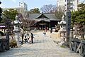
Four Pillars Shrine
-
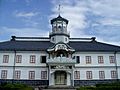
Kaichi School
-
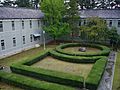
Garden in former Matsumoto High School (now part of Shinshu University)
-
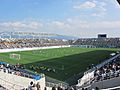
Matsumoto Alwin football stadium
-
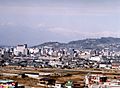
View of downtown Matsumoto from Mount Koubou
-
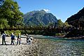
Kappa Bridge in Kamikōchi
-
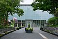
Matsumoto City Museum of Art
-

Matsumoto Ukiyoe Museum
-
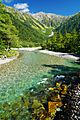
Azusa River in Kamikōchi
-
Taisho Pond in Kamikōchi


See also
 In Spanish: Matsumoto (Nagano) para niños
