Löbau-Zittau Rural District facts for kids
Quick facts for kids
Löbau-Zittau
|
|
|---|---|
 |
|
| Country | |
| State | Saxony |
| Adm. region | Dresden |
| Capital | Zittau |
| Area | |
| • Total | 698.51 km2 (269.70 sq mi) |
| Population
(2001)
|
|
| • Total | 152,304 |
| • Density | 218.0413/km2 (564.724/sq mi) |
| Time zone | UTC+1 (CET) |
| • Summer (DST) | UTC+2 (CEST) |
| Vehicle registration | ZI |
| Website | http://www.lra-loebau-zittau.de |
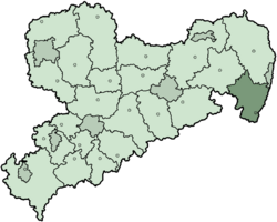
Löbau-Zittau (which is Wokrjes Lubij-Žitawa in Sorbian) was a special area called a district (or Kreis in German) in the eastern part of Saxony, Germany. It was located right on the borders of Germany with Poland to the east and the Czech Republic to the south.
A Look at Löbau-Zittau
Where is Löbau-Zittau?
This district was found in the eastern part of the German state of Saxony. It shared its borders with two other countries: Poland on its eastern side and the Czech Republic to its south. This made it an important place for travel and trade between these nations.
A Quick Look at History
The Löbau-Zittau district was created in 1994. This happened when two older districts, Löbau and Zittau, decided to join together. Later, in 2008, the district changed again. The independent city of Görlitz (which was a city that managed itself) became part of the district. This made the area even bigger.
 | Bayard Rustin |
 | Jeannette Carter |
 | Jeremiah A. Brown |

