
Mackay Reservoir (Idaho) facts for kids
Quick facts for kids Mackay Reservoir |
|
|---|---|

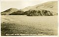
Mackay Reservoir, c. 1920
|
|

Mackay Reservoir
Location in Idaho

Mackay Reservoir
Location in the United States
|
|
| Location | Custer County, Idaho United States |
| Coordinates | 43°57′11″N 113°40′27″W / 43.95306°N 113.67417°W |
| Type | reservoir |
| Primary inflows | Big Lost River |
| Primary outflows | Big Lost River |
| Basin countries | United States |
| Built | 1918 |
| Water volume | 45,000 acre-feet (56,000,000 m3) |
| Surface elevation | 6,060 feet (1,850 m) |
Mackay Reservoir is a large man-made lake located in Custer County, Idaho, in the United States. It was created on the Big Lost River.
Contents
About Mackay Reservoir
This reservoir sits in the beautiful Lost River Valley, just about 4 miles (6.4 km) northwest of the town of Mackay. It's nestled below the tall Lost River Range mountains.
The area around Mackay Reservoir is a great place for outdoor fun! You can go boating, fishing, camping, and even hunting there. The lake was formed by the Mackay Dam, which was built way back in 1918. The dam was created by the Big Lost River Irrigation District.
You can find U.S. Route 93 traveling along the eastern side of the reservoir. Every year, the towns of Mackay and Arco put on a special Fourth of July fireworks show at the reservoir.
How Big is the Reservoir?
The dam that holds back the water is 67 feet (20 meters) high. The reservoir itself covers a huge area of 1,392 acres (563 hectares). It can hold a lot of water, about 45,050 acre-feet, which is like 14.6 billion gallons!
The Idaho Department of Fish and Game adds new fish to the reservoir every year. This helps keep it a great spot for fishing. The reservoir is located between the Pioneer Mountains and the Lost River Range, right at the base of Mt. McCaleb.
History of the Dam
The dam was finished in 1918 by a company called the Utah Construction Company. Its main job was to provide water for irrigation canals in the Lost River Valley. This water helped local farms grow their crops.
A Time of Trouble
In June 1933, during a time when there wasn't much rain, some people caused damage to the dam's control tower. They were likely farmers who needed more water and thought the dam was holding it back. Luckily, the main part of the dam was not harmed.
Because of this event, the Utah Construction Company decided to sell the dam for a lower price. In 1936, the town of Mackay bought the dam under the name of the Lost River Irrigation District.
Celebrating "The Res"
Since buying the reservoir, the town of Mackay has held an annual barbecue in the fall. This celebration is to remember when they bought the reservoir, which locals lovingly call "The Res."
The Mackay Reservoir also survived a very strong earthquake in 1983, called the 1983 Borah Peak earthquake. Even though nearby towns like Mackay and Challis had a lot of damage, the reservoir held strong.
Images for kids
-
Mackay Reservoir, c. 1920
