Mae West Peaks facts for kids
Quick facts for kids Mae West Peaks |
|
|---|---|

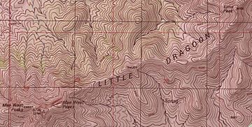
Portion of the USGS Topographic map of the main ridge of the Little Dragoons with the Mae West Peaks in the lower left corner
|
|
| Highest point | |
| Elevation | 6,732 ft (2,052 m) NAVD 88 |
| Prominence | 2,026 ft (618 m) |
| Geography | |
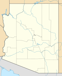
| Location | Cochise County, Arizona, U.S. |
| Parent range | Little Dragoon Mountains |
| Topo map | USGS Dragoon |
Mae West Peaks are two mountain tops located in Cochise County, Arizona. The taller of these two peaks used to be called Lime Peak. The height and location details you see in the box above are for this taller peak. These peaks are part of the Little Dragoon Mountains. They are found northwest of Texas Canyon and about 3.3 miles (5.3 km) west-southwest of the old mining town of Johnson, Arizona.
Why the Name Mae West Peaks?
These mountain tops got their name because their shape reminded people of the famous actress Mae West. She was well-known for her unique style.
The name "Mae West Peaks" was officially recorded by the United States Geological Survey (USGS) between 1976 and 1980. The USGS is a science agency that studies the Earth. The name was added to their Geographic Names Information System on February 8, 1980. This system keeps track of all the official names for places in the United States.
The Other Lime Peak
On the very same day, February 8, 1980, another peak nearby was officially named Lime Peak. This other peak is about 6,655 feet (2,028 meters) tall. It is located about 1.8 miles (2.9 km) to the northeast of Mae West Peaks. This peak is also part of the Little Dragoon Mountains.
 | May Edward Chinn |
 | Rebecca Cole |
 | Alexa Canady |
 | Dorothy Lavinia Brown |


