Lime Peak (Arizona) facts for kids
Quick facts for kids Lime Peak |
|
|---|---|

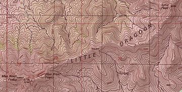
Topographic map of the ridge of the Little Dragoon Mountains with Lime Peak in the upper right corner.
|
|
| Highest point | |
| Elevation | 6,658 ft (2,029 m) NAVD 88 |
| Prominence | 695 ft (212 m) |
| Geography | |
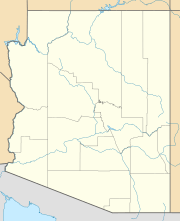
| Location | Cochise County, Arizona, U.S. |
| Parent range | Little Dragoon Mountains |
| Topo map | USGS Dragoon |
Lime Peak is a mountain peak located in Cochise County, Arizona, in the United States. It stands north of Interstate 10, a major highway. The peak is found between the towns of Benson and Willcox. It is about 6.6 miles (10.6 kilometers) northwest of Dragoon, Arizona.
Lime Peak is one of three named peaks within the Little Dragoon Mountains. Two of these peaks are sometimes called the Mae West Peaks. This nickname came about because their shape was thought to look like the figure of the famous actress Mae West.
Discovering Lime Peak
Lime Peak is an important part of the landscape in southeastern Arizona. It rises to an elevation of 6,658 feet (2,029 meters) above sea level. This makes it one of the higher points in the Little Dragoon Mountains. The mountain range itself is known for its rugged beauty.
Where is Lime Peak Located?
Lime Peak is situated in Cochise County, Arizona. This county is in the southeastern part of the state. The peak is easy to spot from Interstate 10. This highway connects many towns in the region. Its location makes it a notable landmark for travelers.
How Lime Peak Got Its Name
The name "Lime Peak" has an interesting history. In 1935, the Coast And Geodetic Survey first referred to the tallest of the Mae West peaks as "Lime." This was an early step in mapping the area.
Later, in 1984, the United States Board on Geographic Names officially gave the name Lime Peak to its current location. Before this, the peak was also known by another name, "Johnson Peak." The official naming helped to make sure everyone used the same name for this important landmark.
 | Claudette Colvin |
 | Myrlie Evers-Williams |
 | Alberta Odell Jones |


