
Maes Knoll facts for kids
 |
|
| Location | near Norton Malreward and Bristol |
|---|---|
| Region | Somerset, England |
| Coordinates | 51°23′31.46″N 2°34′32.02″W / 51.3920722°N 2.5755611°W |
| Type | Hill fort |
| History | |
| Periods | Iron Age |
| Site notes | |
| Condition | some damage |

Maes Knoll (also called Maes tump or Maes Knoll tump) is an ancient Iron Age hill fort in Somerset, England. It sits on the eastern end of the Dundry Down ridge. You can find it south of the city of Bristol and north of the village of Norton Malreward. Maes Knoll is a Scheduled Ancient Monument, which means it's a very important protected historical site.
What is a Hill Fort?
Hill forts are large, fortified settlements built on hills. People started building them in Britain around 3,000 years ago. These forts were often used for protection and as homes for communities.
Historians and archaeologists have different ideas about why hill forts were built. Some believe they were military bases to defend against invaders. Others think they were built because more people meant less land, leading to conflicts.
When iron became more common, it changed how people lived and traded. This led to new groups gaining power. Many experts agree that hill forts offered safe places for communities. They were especially useful when people had disagreements that turned into fights.
Exploring Maes Knoll
Maes Knoll is a large, flat area shaped like a triangle. It measures about 119 meters (390 feet) long and 25 meters (84 feet) wide. The fort covers about 8 hectares (20 acres) and stands 14 meters (45 feet) tall.
The people who built it made the steep sides of the hill even steeper. They also built strong walls, called ramparts, around the northern, eastern, and southwestern edges. The highest point of the fort is 197 meters (646 feet) above sea level. From here, you can see far across the land.
You can get clear views north to Bristol and east to Bath. You can also see the Cotswold Hills, Chew Valley Lake, and the Mendip Hills to the south. The rocks under Maes Knoll are from the Jurassic period, which was millions of years ago.
History of Maes Knoll
Experts believe the Dobuni tribe built Maes Knoll around 250 BC. The Dobuni were one of the Celtic tribes living in Britain before the Romans arrived.
The name "Maes Knoll" has an interesting meaning. "Maes" comes from an old British word meaning "flat top." This word came from the Latin word "mensa," which means "table." "Knoll" or "knowle" is an Old English word for "hill." So, Maes Knoll means "flat-topped hill."
On the north-western side of the fort, there's a large earthen mound called Maes Knoll Tump. This mound is about 7.5 meters (25 feet) taller than the rest of the fort's defenses. It is 60 meters (197 feet) wide and has a defensive ditch around it.
Later, another ancient earthwork called the Wansdyke was built. It runs west from Maes Knoll along the north side of Dundry Hill. It also goes south-east from the fort.
During the Second World War, Maes Knoll Tump was used for defense. A small hut made of corrugated iron stood on top of the tump. Dundry Home Guard soldiers used this hut. They watched for enemy aircraft and possible parachute or glider invasions of Bristol. The flat area just east of the tump had about 50 stone piles, called cairns. These were put there to stop enemy gliders from landing.
Images for kids
-
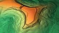
A 3D view of the digital terrain model of Maes Knoll.

