
Mahakali Zone facts for kids
Quick facts for kids
Mahakali
महाकाली अञ्चल
|
|
|---|---|
 |
|
| Country | |
| Region | Far-Western Development Region |
| Time zone | UTC+5:45 (Nepal Time) |
Mahakali (Nepali: महाकाली अञ्चल) was a special administrative area, known as a zone, in the country of Nepal. It was located in the Far-Western Development Region of Nepal. This zone covered a total area of 6,205 square kilometers.
Contents
Understanding Mahakali Zone
Mahakali was one of the fourteen zones that made up Nepal's administrative divisions for many years. These zones were like large regions that helped organize the country. The Mahakali Zone was named after the Mahakali River, which forms part of Nepal's western border.
Location and Geography
The Mahakali Zone was situated in the far western part of Nepal. It was part of the larger Far-Western Development Region. This area of Nepal is known for its diverse landscapes. It includes parts of the Terai plains, which are flat and fertile, and also extends into the hills and mountains.
Administrative Changes
In 2015, Nepal changed its administrative system. The old zones, including Mahakali, were replaced by new provinces. This change was part of a big update to how the country is governed. So, while Mahakali no longer exists as a zone, the area it covered is now part of Sudurpashchim Province.
Related pages
Images for kids
-
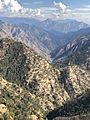
Mahakali in March 2019

See also
 In Spanish: Zona de Mahakali para niños
