Mahates facts for kids
Quick facts for kids
Mahates
|
||
|---|---|---|
|
Municipality and town
|
||
|
||

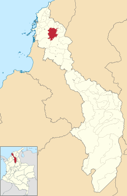
Location of the municipality and town of Mahates in the Bolívar Department of Colombia
|
||
| Country | ||
| Department | Bolívar Department | |
| Population
(Census 2018)
|
||
| • Total | 26,075 | |
| Time zone | UTC-5 (Colombia Standard Time) | |
| Climate | Aw | |
Mahates is a cool town in northern Colombia, right by a river in the Bolívar Department. It was started on April 17, 1533, by a Spanish explorer named Pedro de Heredia.
Mahates also includes a special village called Palenque de San Basilio. Most people there are Afro-Colombians, whose families came from Africa a long time ago. They have kept their amazing old traditions alive! In 2005, UNESCO said Palenque de San Basilio was a 'Masterpiece of Oral and Intangible Heritage of Humanity,' which means it's super important for the world's culture.
Contents
History of Mahates
Mahates was founded in 1533 by Pedro de Heredia, soon after he started the city of Cartagena de Indias. Later, the land was given to his son, Antonio de Heredia. Eventually, a church was built there. Because many people moved there, Mahates quickly grew into an important village. It even had its own court until the late 1800s.
In 1650, the Canal del Dique was built. This made Mahates a busy place for trade, as many goods passed through it. Over time, Mahates has changed its official status many times, from a 'Partition' to a 'Municipality'.
In 1860, a big fire destroyed two-thirds of the village. At that time, Mahates was part of the Sovereign State of Bolívar and was the capital of the Province of Mahates. This province also included the towns of Calamar and Arjona.
By 1865, the Province of Mahates became less important and lost some of its land. When a railway was built between Cartagena de Indias and Calamar in 1894, river trade became less important. This made Mahates less central for travel and business. Later, a new highway was built, but it went about 10 kilometers away from the town.
Geography of Mahates
The municipality of Mahates is located in the northern part of the Bolívar Department. It shares borders with several other towns. To the east, it borders Calamar and Arroyo Hondo. To the northeast, it borders Soplaviento. San Estanislao is to the north, and Arjona is to the west. To the southwest, you'll find María La Baja, and to the south, San Juan Nepocumeno. The total area of Mahates is about 466 square kilometers.
People of Mahates
Ethnic Groups
Most people in Mahates are mulattos, which means they have mixed European and African heritage. In the village of San Basilio de Palenque, most residents are dark-skinned Afro-Colombians. They have kept many customs from their African ancestors. They also speak their own special language called Palenquero.
Population Numbers
Mahates has an economy based on farming. This means most people (about 62%) live in the countryside. The rest (about 38%) live in the town area. In 1985, the municipality had 18,831 people. By 1993, the population had slightly decreased to 18,412 people.
Parts of Mahates
Town Neighborhoods
- 12 October
- 16 May
- 7 August
- Centella
- El Campo
- El Puente
- La Concepcion
- La Guayana
- La Loma
- La Vera
- Remanso de Paz
- Santander
Villages (Corregimientos)
- Evitar
- Gamero
- Malagana
- Mandinga
- San Basilio de Palenque
- San Joaquin
Small Rural Areas (Veredas)
- Cruz del Vizo
- La Manga
- Paraiso
- Pava
- Raicero
- Songó
- Todo Sonrisa
See also
 In Spanish: Mahates para niños
 | James Van Der Zee |
 | Alma Thomas |
 | Ellis Wilson |
 | Margaret Taylor-Burroughs |


