
Mahdia, Guyana facts for kids
Quick facts for kids
Mahdia
|
|
|---|---|
|
Town and regional capital
|
|

Commercial area in Mahdia, May 2006
|
|

Mahdia, Guyana
Location in Guyana
|
|
| Country | |
| Region | Potaro-Siparuni |
| Elevation | 1,360 ft (415 m) |
| Population
(2012)
|
|
| • Total | 2,563 |
Mahdia is a town in Guyana. It's located in the middle of the country. It sits high up, about 415 m (1,362 ft) (1,360 feet) above sea level.
This town is a hub for gold and diamond mining. Because of mining, Mahdia's economy can go up and down. Many people, from Guyana and other countries, come here hoping to find wealth through mining.
Contents
Who Lives in Mahdia?
In 2012, Mahdia had 2,563 people. These people belong to three main groups.
- The Patamonas are an indigenous (native) Amerindian tribe. They are involved in farming, hunting, and mining.
- Coast Landers are people from Guyana's coast. They moved to Mahdia to find jobs, mostly in mining.
- Islanders are immigrants and their families from Caribbean Islands. Many came from St. Lucia and Dominica. They often focus on farming and making charcoal.
Recently, a new group of people, the Brazilians, have also moved to Mahdia. They are involved in mining and other businesses.
Festivals and Community Life
Every year on September 10, the Amerindians celebrate Heritage Month. This takes place in Campbelltown, a community near Mahdia.
The Islanders celebrate the La Rose Festival at the end of August. This special festival first started in St. Lucia.
Mahdia is the main administrative center for Region 8, called Potaro-Siparuni. This means it has important buildings and services:
- A small hospital (called a cottage hospital)
- Schools for young children, primary students, and secondary students
- A business area with shops, clothing stores, a gas station, and 11 restaurants
- Two guest houses for visitors
- A police station
- A post office
- Two wells that provide water
- A main office for the regional government
- An airstrip for small planes
Even with these services, people in Mahdia still rely on rainwater. They also get water from the Salbora Falls. Local business owners provide electricity to the town.
Mahdia's History
Mahdia was founded in 1884 by Africans. They had been freed from slavery. Most of them traveled from areas like Berbice and the East Coast of Demerara. They came looking for gold.
The British Consolidated Mining Company later expanded mining in Mahdia. They also set up government offices. At this time, you could only reach Mahdia by traveling on water.
Gold mining brought many people from St. Lucia to Mahdia. They brought their French Patois (Kweol) language. They also brought cultural traditions like the La Rose celebration.
In November 1933, a bridge was built over the Garraway Stream. This bridge connected Mahdia to Bartica by a trail. It is a suspension bridge, meaning it hangs from cables. It was named the Denham Suspension Bridge. It was named after the governor at the time, Sir Edward Denham. This bridge is still used today and is a popular spot for tourists. In 2018, Mahdia officially became a town.
Gold and Diamond Mining
Mahdia's mining district has about 150 land dredges. These are machines used for mining. Most miners use excavators to dig up the top layer of earth, called the overburden. Then, they use gravel pumps to get the gravel with gold from the pits.
Sometimes, these mining pits are not refilled. This can create places for anopheles mosquitoes to breed. These mosquitoes can spread malaria.
In 2005, the Guyana Geology and Mines Commission started to make rules stronger. These rules help protect the environment. This has helped reduce pollution in waterways. It also encourages miners to refill pits and replant trees in areas where forests were removed.
Mahdia's Climate
Mahdia has a tropical rainforest climate. This means it gets a lot of rain all year round.
| Climate data for Mahdia | |||||||||||||
|---|---|---|---|---|---|---|---|---|---|---|---|---|---|
| Month | Jan | Feb | Mar | Apr | May | Jun | Jul | Aug | Sep | Oct | Nov | Dec | Year |
| Mean daily maximum °C (°F) | 29.6 (85.3) |
29.7 (85.5) |
30.1 (86.2) |
30.7 (87.3) |
30.8 (87.4) |
30.5 (86.9) |
30.5 (86.9) |
31.1 (88.0) |
31.6 (88.9) |
31.6 (88.9) |
31.0 (87.8) |
30.2 (86.4) |
30.6 (87.1) |
| Daily mean °C (°F) | 25.5 (77.9) |
25.6 (78.1) |
26.0 (78.8) |
26.5 (79.7) |
26.9 (80.4) |
26.5 (79.7) |
26.4 (79.5) |
27.0 (80.6) |
27.3 (81.1) |
27.3 (81.1) |
26.8 (80.2) |
26.1 (79.0) |
26.5 (79.7) |
| Mean daily minimum °C (°F) | 21.4 (70.5) |
21.5 (70.7) |
21.9 (71.4) |
22.4 (72.3) |
23.0 (73.4) |
22.5 (72.5) |
22.4 (72.3) |
22.9 (73.2) |
23.1 (73.6) |
23.1 (73.6) |
22.6 (72.7) |
22.0 (71.6) |
22.4 (72.3) |
| Average rainfall mm (inches) | 269 (10.6) |
185 (7.3) |
185 (7.3) |
232 (9.1) |
364 (14.3) |
418 (16.5) |
326 (12.8) |
263 (10.4) |
114 (4.5) |
93 (3.7) |
140 (5.5) |
237 (9.3) |
2,826 (111.3) |
| Source: Climate-Data.org | |||||||||||||
Images for kids
-
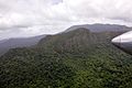
Some Peaks Close to Mahdia
-
-
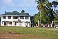
Mahdia Police Station
-
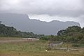
Mahdia Airstrip


See also
 In Spanish: Mahdia (Guyana) para niños
