
Main Street Unionville facts for kids
Quick facts for kids
|
|
|---|---|
| (Main Street) | |

Main Street Unionville is shown in red
|
|
| Route information | |
| Length | 2.75 km (1.71 mi) |
| Existed | 1840–present |
| Major junctions | |
| South end | Enterprise Drive / Unionville Gate |
| North end | Rosemary Close |
| Location | |
| Counties: | York |
| Major cities: | Markham |
| Highway system | |
| Roads in Ontario | |

Main Street Unionville is a special street located in the historic town of Unionville. This town is part of Markham, Ontario, Canada. It's like a main street in many towns, but this one is very important for visitors.
Many buildings along Main Street Unionville look almost the same as they did when the town started in 1794! People love this street for its cozy restaurants, beautiful parks, and old-fashioned European feel. Every year, the street hosts the exciting Unionville Festival, which brings thousands of people to the area.
Contents
What's Special About Main Street?
- Local Name: Everyone calls it Main Street.
- Cool Places to See: You can visit the Historical Village of Unionville, the Varley Art Gallery, and Starks Barber Company.
- Road Details: From Unionville Gate to Carlton Road, it's a two-lane road where cars drive slowly, usually 40 kilometers per hour. Sometimes, parked cars make it a bit narrower. North of Carlton Road, it's also a paved, two-lane street.
- What You'll Find: Most of the street has shops and park areas. Some parts still have homes from way back in 1794!
A Look Back: Main Street's History
Fun and Filming on Main Street
Main Street Unionville is a lively place! It hosts annual jazz and Celtic music festivals. In the summer, you can enjoy live music at the new bandstand.
Did you know this street has been on TV? It was used as the fictional town of Stars Hollow in the first season of the TV show Gilmore Girls. Other movies filmed here include The Scream Team in 2002 and Secrets of Eden in 2011.
The 1994 movie In the Mouth of Madness, directed by John Carpenter, also used the northern part of the street. It pretended to be a town in New England, especially the outside of the Unionville Arms Pub.
How the Road Changed Over Time
Main Street Unionville was originally known as the "6th line" of Markham Township. It wasn't really developed until about 1840. That's when a mill was built near what is now Carlton Road. The mill needed water from a pond, but a swamp made it hard to travel. So, a road was built along a higher area, and this became the main path.
Around the same time, land near the road and 15th Avenue (now Highway 7) was divided up. But it wasn't built on until the railway arrived in 1872. Unionville was the center of the township and even held the town offices until the 1970s.
In the late 1960s, new homes were built nearby. This made people notice that the old buildings in the business area were looking a bit run down. The government wanted to make the road wider, which would have meant tearing down these old buildings.
But people in Unionville were upset! They started the Unionville Annual Festival to get attention and raise money to stop the widening. Local politicians soon joined in, and the road widening was stopped.
In the early 1980s, a new road was built around Main Street Unionville to help with heavy traffic. This new road became Kennedy Road. The original road was then renamed Main Street Unionville. With these changes, the old buildings were fixed up, and the street became the unique Victorian Village we see today.
Unionville's Story
Important Places to See
- Historical Village of Unionville
- Varley Art Gallery
- Unionville Library
- Unionville Village Firehall
Images for kids
-

Central United Church
-
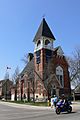
Old Unionville church, built by the architect of Casa Loma
-
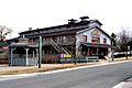
Unionville Planing Mill
-
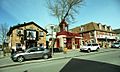
Unionville Main Street
-
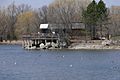
Toogood Pond


Main Crossings
The following table lists the major junctions along Main Street Unionville. The entire route is located in Markham, Ontario, within the Regional Municipality of York.
| km | mi | Destinations | Notes | |
|---|---|---|---|---|
| 0.0 | 0.0 | Cul-de-sac south of Enterprise Avenue | ||
| 0.2 | 0.12 | Enterprise Avenue / Unionville Gate | The Markham Pan Am Centre is located southwest of this crossing. | |
| 0.8 | 0.50 | |||
| 1.7 | 1.1 | Carlton Road | ||
| 2.4 | 1.5 | Rosemead Close | The Fire Station exit is just north of this crossing. | |
| 1.000 mi = 1.609 km; 1.000 km = 0.621 mi | ||||
