
Malabar, New South Wales facts for kids
Quick facts for kids MalabarSydney, New South Wales |
|||||||||||||||
|---|---|---|---|---|---|---|---|---|---|---|---|---|---|---|---|

Long Bay, Malabar
|
|||||||||||||||
| Population | 5,420 (2016 census) | ||||||||||||||
| Postcode(s) | 2036 | ||||||||||||||
| Elevation | 37 m (121 ft) | ||||||||||||||
| Location | 12 km (7 mi) south-east of Sydney CBD | ||||||||||||||
| LGA(s) | City of Randwick | ||||||||||||||
| State electorate(s) | Maroubra | ||||||||||||||
| Federal Division(s) | Kingsford Smith | ||||||||||||||
|
|||||||||||||||
Malabar is a suburb located in the Eastern Suburbs of Sydney, New South Wales, Australia. It is about 12 kilometres south-east of the Sydney central business district. Malabar is part of the City of Randwick local government area.
Contents
Exploring Malabar's Location
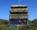
Malabar is a coastal suburb built around a beautiful area called Long Bay. Most of Malabar is made up of homes. However, there are also large areas used for the Randwick Golf Course, the ANZAC Rifle Range, and the Long Bay Correctional Centre. You can find a small group of shops on Prince Edward Street, near Anzac Parade. To the north, Malabar is bordered by Malabar Headland. This headland is home to the Malabar Battery, which is an old fort built during World War II.
Malabar's Interesting History
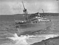
Malabar got its name from a ship called the MV Malabar. This ship was a passenger and cargo steamer. It was shipwrecked in thick fog on rocks at Miranda Point on April 2, 1931. This point is on the northern side of Long Bay. The ship itself was named after Malabar, a region in Kerala, India. This Indian region is famous for its history as a major spice trading centre.
Before the Shipwreck
Before the ship sank, the suburb was known as either Brand or Long Bay. Long Bay is believed to have been an important camping and healing place for the local Indigenous community. This area was used by them between Sydney and Botany Bay. You can still find Aboriginal engravings on Malabar Headland. An old historian named Obed West said in 1882 that Aboriginal people called Long Bay 'Boora'. He also claimed that a rock shelter on the south side of Long Bay was used by Aboriginal people during a smallpox outbreak in the late 1700s.
Naming the Suburb
After many local residents asked for a new name, Malabar was officially named on September 29, 1933. The headland at Malabar has seen five shipwrecks over the years. These include the St Albans in 1882, the MV Malabar in 1931, Try One in 1947, and the SS Goolgwai in 1955. An unnamed barge also sank in 1955.
Early Development
The land in this area was originally set aside for the Church and Schools Corporation. The money earned from this land was meant to support clergy and teachers. In 1866, there was an effort to create a village at Long Bay. The surveyor general asked for bids to clear timber and set up street name posts. Then, land lots were sold in 1869.
The suburb was officially called the Village of Brand in 1899. However, most people still called it Long Bay. Not many people moved to the area at first. The suburb only started to grow after a tram line was built to the Coast Hospital in 1901. By the early 1900s, the village had two community halls. These were Anderson's Hall and Picnic Grounds and Dudley's Hall. Dudley's Hall was even used as a school until Long Bay Public School opened in 1909.
Holiday Camps and Housing
Between 1910 and 1920, some business people bought cheap land at Long Bay. They set up tents and huts for visitors who came to the beach on weekends. Residents complained about the poor conditions and how these holiday camps affected land values. During this time, some people also lived in shacks in the sand dunes behind Long Bay. They were forced to live this way because there was a shortage of housing in inner Sydney.
Correctional Facilities
Construction of a correctional facility for women began in 1902. It was built on a 70-acre site south of the village. This facility officially opened in August 1909. A correctional facility for men opened later in 1914. The women's facility became part of the men's prison in the late 1950s. It was then known as the Long Bay Penitentiary. The women's prison was no longer used after the Mulawa Correctional Centre opened in 1969.
Life Saving Club and Water Quality
The Long Bay Life Saving and Amateur Swimming Club was formed after World War I. They met at the ambulance building on Bay Parade. A clubhouse was built in 1922. In 1916, a large sewer pipe was built on Malabar Headland. By 1959, more and more sewage was being released. This greatly affected the water quality at Long Bay. Some club members left to start a new club at South Maroubra. By 1973, the Malabar club had to close down. In the 1990s, a new deep-water sewer pipe was built. This helped improve the water quality. However, the old clubhouse was torn down in the same decade because it had severe water damage.
ANZAC Rifle Range
The rifle range on Malabar headland was first known as the Long Bay Rifle Range. People have been using this site for shooting since the 1850s. This helped with local security. The original ANZAC Rifle Range at Holsworthy closed in 1967. The rifle clubs then moved to the Long Bay Rifle Range at Malabar. The range at Malabar was renamed the ANZAC Rifle Range in 1970. This was done to remember the ANZAC soldiers who died in the World Wars and the Korea Campaign.
The headland was shared by several groups. These included the Sporting Shooters Association of Australia and the NSW Smallbore and Air Rifle Association. The Sydney Model Aero Club and the Malabar Riding School also used the land. However, the government ended their leases in November 2011.
Malabar Headland's Future
The western part of the headland was given to the NSW Government on March 2, 2012. This area is 17.7 hectares. It has parts of the Eastern Suburbs Banksia Scrub, eucalypt woodlands, and coastal heath land. These areas are now part of a National Park. There were plans to turn the rest of the headland into a National Park. This would happen after the rifle range was moved and the area was made safe for public use. However, the NSW Rifle Association won a court case against the government. This stopped the plans.
In January 2015, a report suggested selling the land for development. But this idea caused a lot of anger in the community. The government quickly said no to the plan. In March 2015, new plans were announced. These plans included adding more of the headland to the National Park and bringing horses back. The future of the rest of Malabar Headland is still being decided.
Malabar's Heritage Sites
Malabar has some places that are listed for their historical importance:
- 1250 Anzac Parade: Long Bay Correctional Centre
- Franklin Street: Malabar Headland
Malabar's Population
According to the 2016 census, there were 5,420 people living in Malabar.
- About 6.6% of the people were Aboriginal and Torres Strait Islander.
- Most people, 67.7%, were born in Australia.
- The next most common countries of birth were England (3.5%) and China (2.2%).
- About 51.0% of people spoke only English at home.
Famous People from Malabar
- Braith Anasta, an Australian rugby league player
- Errol Gulden, an AFL Footballer
Gallery
-
Malabar Battery observation post
-
The wreck of the Malabar
-
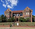
St Andrew's Primary School, Prince Edward Street
-
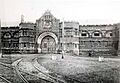
Long Bay Gaol
-
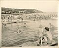
People at Malabar Beach


