Mallard Island facts for kids

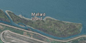
USGS aerial imagery of Mallard Island; Suisun Bay is to the north, and West Pittsburg is to the south across Mallard Slough.
|
|
| Geography | |
|---|---|
| Location | Northern California |
| Coordinates | 38°02′31″N 121°55′07″W / 38.04194°N 121.91861°W |
| Adjacent bodies of water | Suisun Bay |
| Highest elevation | 3 ft (0.9 m) |
| Administration | |
|
United States
|
|
| State | |
| County | Contra Costa |
Mallard Island is a small piece of land surrounded by water in Suisun Bay, California. It sits right where the Sacramento River and San Joaquin River come together. This area is known as the Sacramento–San Joaquin River Delta. Mallard Island is part of Contra Costa County.
Where is Mallard Island?
Mallard Island is located in Northern California. Its exact spot is 38°02′31″N 121°55′07″W / 38.04194°N 121.91861°W. It is a very small island.
A Special Watery Place
The island is found in Suisun Bay. This bay is a special place where fresh water from rivers mixes with salt water from the ocean. It is also part of the Sacramento–San Joaquin River Delta. A delta is a landform that forms at the mouth of a river. It is created by sediment that the river carries downstream.
How Big is the Island?
In 1981, the United States Geological Survey measured the island's height. They found its elevation to be about 3 ft (0.91 m) above sea level. This means the island is very low to the ground.
 | May Edward Chinn |
 | Rebecca Cole |
 | Alexa Canady |
 | Dorothy Lavinia Brown |


