Malmesbury, South Africa facts for kids
Quick facts for kids
Malmesbury
|
|
|---|---|
|
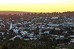
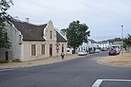
Top, The Malmesbury skyline at dusk. Middle left, a view down Loedolff Street. Middle right, the Dutch Reformed Church in Malmesbury. Lower left, the Malmesbury Museum. Lower right, the Baron Von Elgg Victorian era home built in 1890, the town has a number of similar surviving Victorian era homes.
|
|
| Country | South Africa |
| Province | Western Cape |
| District | West Coast |
| Municipality | Swartland |
| Established | 1745 |
| Area | |
| • Total | 18.8 km2 (7.3 sq mi) |
| Population
(2011)
|
|
| • Total | 35,897 |
| • Density | 1,909/km2 (4,945/sq mi) |
| Racial makeup (2011) | |
| • Black African | 24.9% |
| • Coloured | 55.3% |
| • Indian/Asian | 0.5% |
| • White | 18.4% |
| • Other | 0.9% |
| First languages (2011) | |
| • Afrikaans | 73.9% |
| • Xhosa | 16.3% |
| • English | 3.8% |
| • Sotho | 3.1% |
| • Other | 2.8% |
| Time zone | UTC+2 (SAST) |
| Postal code (street) |
7300
|
| PO box |
7299
|
| Area code | 022 |
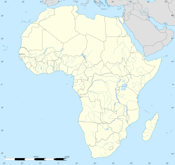
Malmesbury is a town in the Western Cape province of South Africa. It is home to about 36,000 people and is located about 65 kilometers north of Cape Town.
The town is the biggest in the Swartland area. This name means 'black land'. It comes from a local plant called renosterbos ('rhino bush'), which turns black in the hot, dry summers. The area is famous for growing grain and grapes for wine. It also has many sheep and poultry farms.
Malmesbury was named after the Earl of Malmesbury, who was the father-in-law of Sir Lowry Cole. Early settlers were drawn to the area because of a warm sulphur spring. People believed this spring could help cure rheumatism, a condition that causes pain in joints. The first farms were set up here in 1703.
When a new Dutch Reformed church was built here, the area was first called Zwartlands-kerk (Swartland Church). But in 1829, it was renamed Malmesbury. The town officially became a municipality in 1860. Today, the spring is no longer a main attraction. A shopping center now stands where the spring once was, with only a decorative fountain to mark its spot.
Contents
People from Malmesbury
Many interesting people have come from Malmesbury. Here are a few:
- McNeil Hendricks
- Maggie Laubser
- Pieter-Steph du Toit
- Johan du Toit
- Dean Smith
- Angelo Fabian Johnson
- Daclin Zégan Miller
- Lifa Sifile
- Marius van Heerden
- Hennie Smit
About the Population
In 2011, a census counted the people living in Malmesbury. Here are some interesting facts from that census:
- The town covers an area of about 18.8 square kilometers.
- The total population was 35,897 people.
- There were 9,473 households, which are groups of people living together.
Gender Distribution
The population was almost equally split between males and females:
- Male: 18,016 people (50.2%)
- Female: 17,880 people (49.8%)
Racial Groups
The census also looked at the different racial groups in Malmesbury:
- Coloured people made up the largest group at 55.3%.
- Black African people were 24.9% of the population.
- White people were 18.4%.
- Indian or Asian people were 0.5%.
- Other groups made up 0.9%.
Main Languages Spoken
People in Malmesbury speak many languages. The most common ones are:
- Afrikaans: 73.9% of people speak this as their first language.
- isiXhosa: 16.3% of people speak this.
- English: 3.8% of people speak this.
- Sesotho: 3.1% of people speak this.
- Other languages make up the rest.
Getting Around Malmesbury
Malmesbury has good ways to travel, both by train and by road.
Train Travel
Malmesbury is on a main railway line that connects to Cape Town. The town's railway station is the end point for the Metrorail Western Cape train network. You can take a train from Malmesbury to Cape Town by going through places like Kalbaskraal and Kraaifontein.
Road Travel
Malmesbury is located along the N7 highway, also known as the “Cape Namibia Route”. This highway goes around the town center. It leads north towards Namibia and south towards Cape Town.
Several other important roads also pass through Malmesbury:
- The R45 goes through the town as “Voortrekker Road”, “Loedolf Street”, and “Piet Retief Street”. It connects Paarl to Vredenburg.
- The R302 comes from Durbanville in the south.
- The R315 comes from Darling in the north-west.
“Voortrekker Road” is the main street in Malmesbury.
Town Symbols
Malmesbury has had different symbols over the years.
Municipal Symbols
From 1860 to 2000, Malmesbury was its own municipality. In 1931, the town council used a symbol with a plough and a sheaf of wheat. This was surrounded by a strap that said Deo frumentoque vires, which means "Strength from God and grain".
Later, in 1963, the council adopted a new coat of arms. This design was officially registered in 1969. The shield of the arms had two golden bundles of wheat on a black background at the top. At the bottom, it showed a golden sea-lion on a red background. The sea-lion came from the symbols of Gustaaf Willem van Imhoff, who helped start the church that led to the town's development. The symbol also had a spade between two rhenosterbos branches at the top, and the same motto: Deo frumentoque vires.
Sports and Activities
Malmesbury offers various sports and activities for everyone.
- If you like adventure, Mother City SkyDiving is just 12 kilometers north of town. They offer Tandem Introductory Skydiving for beginners and jumps for experienced skydivers.
- The town has a Golf, Rugby, and Bowling Club.
- You can also join the international Parkrun event. It's a free 5-kilometer run held regularly for anyone who wants to take part.
 | Sharif Bey |
 | Hale Woodruff |
 | Richmond Barthé |
 | Purvis Young |


