Maloy, Iowa facts for kids
Quick facts for kids
Maloy, Iowa
|
|
|---|---|
 |
|

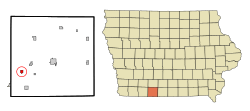
Location of Maloy, Iowa
|
|
| Country | |
| State | |
| County | Ringgold |
| Area | |
| • Total | 0.63 sq mi (1.62 km2) |
| • Land | 0.62 sq mi (1.61 km2) |
| • Water | 0.01 sq mi (0.01 km2) |
| Elevation | 1,119 ft (341 m) |
| Population
(2020)
|
|
| • Total | 22 |
| • Density | 35.43/sq mi (13.68/km2) |
| Time zone | UTC-6 (Central (CST)) |
| • Summer (DST) | UTC-5 (CDT) |
| ZIP code |
50836
|
| Area code(s) | 641 |
| FIPS code | 19-48675 |
| GNIS feature ID | 2395824 |
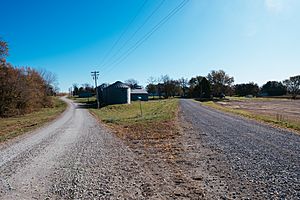
Maloy is a small city located in the southwest part of Ringgold County, Iowa, in the United States. It sits right next to the Little Platte River. According to the 2020 census, only 22 people lived there.
Contents
History of Maloy
Early Settlement and Growth
People started settling in the western part of Ringgold County in the 1850s. The city of Maloy itself was planned out in 1887. This was the same year that a railroad line reached the area, which helped the town grow. Maloy officially became a city in 1901.
In 1917, a two-story brick building was constructed to be the Maloy High School. It served as a high school from 1920 to 1952. After that, it became an elementary school for the Mount Ayr Community School District.
Challenges and Changes
Maloy faced a big challenge on June 17, 1931, when a major fire broke out. The fire destroyed the Catholic Church, five businesses, a house, and a barn.
Later, the school closed its doors in 1972 and was eventually torn down in 1987. The railroad, which once brought both goods and people to Maloy, was taken apart in 1985.
Geography of Maloy
Maloy is located in Iowa, about ten miles west-southwest of a town called Mount Ayr. The Little Platte River flows along the west side of the community.
The United States Census Bureau says that the city covers a total area of about 0.62 square miles (1.6 square kilometers). All of this area is land.
Population of Maloy
| Historical populations | ||
|---|---|---|
| Year | Pop. | ±% |
| 1910 | 127 | — |
| 1920 | 121 | −4.7% |
| 1930 | 112 | −7.4% |
| 1940 | 95 | −15.2% |
| 1950 | 90 | −5.3% |
| 1960 | 68 | −24.4% |
| 1970 | 45 | −33.8% |
| 1980 | 38 | −15.6% |
| 1990 | 36 | −5.3% |
| 2000 | 28 | −22.2% |
| 2010 | 29 | +3.6% |
| 2020 | 22 | −24.1% |
| Source: and Iowa Data Center Source: |
||
2020 Census Information
In 2020, the census counted 22 people living in Maloy. These people lived in 13 households, and 11 of those were families. The city had about 35 people per square mile.
- Racial Makeup: Everyone living in Maloy was identified as White.
- Households: Almost half of the households (46.2%) had children under 18 living there. Most households were married couples living together.
- Age Groups: The average age in Maloy was 49.5 years. About 13.6% of residents were under 20 years old. Many residents were between 45 and 64 years old (36.4%), and 22.7% were 65 or older.
- Gender: The population was made up of 59.1% males and 40.9% females.
2010 Census Information
In 2010, the census showed that 29 people lived in Maloy. They lived in 12 households, with 10 of these being families.
- Racial Makeup: All residents were identified as White.
- Households: About one-third of the households (33.3%) had children under 18. Most households (75%) were married couples.
- Age Groups: The average age was 42.5 years. About 20.7% of residents were under 18, and another 20.7% were 65 or older.
- Gender: The population was 62.1% male and 37.9% female.
Education in Maloy
Public schools in Maloy are part of the Mount Ayr Community School District. This district is responsible for operating the schools that serve the community.
Notable Person from Maloy
- Luke E. Hart was an important person who came from Maloy. He served as the tenth Supreme Knight of the Knights of Columbus, which is a large Catholic fraternal organization.
See also
 In Spanish: Maloy (Iowa) para niños
 | Tommie Smith |
 | Simone Manuel |
 | Shani Davis |
 | Simone Biles |
 | Alice Coachman |

