Manada Creek facts for kids
Quick facts for kids Manada Creek |
|
|---|---|

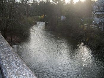
View of the creek from the Jonestown Road Bridge at Manada Hill, Pennsylvania.
|
|
| Country | United States |
| State | Pennsylvania |
| Counties | Dauphin, Lebanon |
| Cities | Sandbeach, Manadahill, Manada Gap, Fort Indiantown Gap |
| Physical characteristics | |
| Main source | Fort Indiantown Gap East Hanover Township, Lebanon County, Pennsylvania, USA 40°26′29″N 76°38′41″W / 40.44139°N 76.64472°W |
| River mouth | Swatara Creek Sand Beach, Dauphin County, Pennsylvania, USA 348 ft (106 m) 40°18′16″N 76°40′08″W / 40.30444°N 76.66889°W |
| Length | 17.0 mi (27.4 km) |
| Basin features | |
| Basin size | 32.2 sq mi (83 km2) |
| Tributaries |
|
Manada Creek is a cool stream in Pennsylvania, United States. It flows for about 17.0-mile (27.4 km) before joining a bigger stream called Swatara Creek. The area of land that drains water into Manada Creek is about 32.2 sq mi (83 km2). The name "Manada" comes from an old Native American word, "menatey," which means "island."
Manada Creek's Journey
Where the Creek Begins
Manada Creek starts high up in the Blue Mountain range. It begins in a place called Fort Indiantown Gap in East Hanover Township. Several smaller streams come together to form the main creek.
The Creek's Path
From its start, Manada Creek flows towards the southwest. It cuts through the mountains in a special valley known as Manada Gap. As it continues, the creek forms a natural border between East Hanover and West Hanover townships.
The creek winds its way through thick forests and wide farmlands. It eventually empties into the Swatara Creek near a small community called Sand Beach. Along its journey, another small stream called Walnut Run also joins Manada Creek in East Hanover Township.
 | Stephanie Wilson |
 | Charles Bolden |
 | Ronald McNair |
 | Frederick D. Gregory |

