Mango, Florida facts for kids
Quick facts for kids
Mango, Florida
|
|
|---|---|

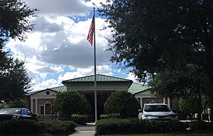
Seffner-Mango Branch Library
|
|

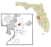
Location in Hillsborough County and the state of Florida
|
|
| Country | United States |
| State | Florida |
| County | Hillsborough |
| Area | |
| • Total | 4.81 sq mi (12.46 km2) |
| • Land | 4.67 sq mi (12.09 km2) |
| • Water | 0.14 sq mi (0.37 km2) |
| Elevation | 52 ft (16 m) |
| Population
(2020)
|
|
| • Total | 12,699 |
| • Density | 2,720.44/sq mi (1,050.38/km2) |
| Time zone | UTC-5 (Eastern (EST)) |
| • Summer (DST) | UTC-4 (EDT) |
| ZIP code |
33550
|
| Area code(s) | 813 |
| FIPS code | 12-42850 |
| GNIS feature ID | 0286372 |
Mango is a special kind of community in Hillsborough County, Florida, United States. It is called a census-designated place (CDP). This means the government counts its population separately, even though it's not an official city or town.
In 2020, about 12,699 people lived in Mango. This was a jump from the 11,313 people counted in 2010.
Contents
Where is Mango Located?
Mango is found in the northern part of Hillsborough County, Florida. It is located at these coordinates: 27°59′22″N 82°18′16″W / 27.98944°N 82.30444°W.
Neighboring Communities
Mango has several neighbors.
- To the north is Thonotosassa.
- To the east is Seffner.
- To the south is Brandon.
- To the west is East Lake-Orient Park.
Major Roads and Highways
Two big highways mark Mango's edges.
- Interstate 4 forms the northern border.
- Interstate 75 is on the western side.
The main road running through the middle of Mango is Dr. Martin Luther King Jr. Boulevard, also known as Florida State Road 574.
Distance to Nearby Cities
- Downtown Tampa is about 10 miles (16 km) to the west.
- Plant City is about 12 miles (19 km) to the east.
Land and Water Area
Mango covers a total area of about 4.8 square miles (12.4 square kilometers). Most of this area is land. About 0.14 square miles (0.3 square kilometers) is water, which is about 2.95% of its total area.
Who Lives in Mango?
The population of Mango has grown over the years.
| Historical population | |||
|---|---|---|---|
| Census | Pop. | %± | |
| 1990 | 8,700 | — | |
| 2000 | 8,842 | 1.6% | |
| 2010 | 11,313 | 27.9% | |
| 2020 | 12,699 | 12.3% | |
| source: | |||
Population in 2000
In 2000, there were 8,842 people living in Mango. They lived in 3,289 households. About 2,302 of these were families. The population density was about 1,927 people per square mile (744 per square kilometer).
Many households had children under 18 (37%). About 46% were married couples. The average household had 2.68 people. The average family had 3.10 people.
The median age in Mango was 33 years old.
- 29.1% of people were under 18.
- 8.7% were between 18 and 24.
- 32.8% were between 25 and 44.
- 21.0% were between 45 and 64.
- 8.4% were 65 or older.
The median income for a household was $33,989. For families, it was $37,818. About 12.6% of the population lived below the poverty line. This included 20.1% of those under 18.
Population Changes by Race (2000-2010)
The community saw changes in its population between 2000 and 2010.
| Race group | Population (2000) | Percentage (2000) | Population (2010) | Percentage (2010) | Numeric change | Percent change |
|---|---|---|---|---|---|---|
| American Indian and Alaska native alone | 51 | 0.58% | 85 | 0.75% | 34 | 66.67% |
| Asian alone | 64 | 0.72% | 173 | 1.53% | 109 | 170.31% |
| Black or African American alone | 569 | 6.44% | 1,744 | 15.42% | 1,175 | 206.50% |
| Native Hawaiian and Other Pacific native alone | 4 | 0.05% | 18 | 0.16% | 14 | 350.00% |
| Some other race alone | 212 | 2.40% | 881 | 7.79% | 669 | 315.57% |
| Two or more races | 252 | 2.85% | 346 | 3.06% | 94 | 37.30% |
| White alone | 7,690 | 86.97% | 8,066 | 71.30% | 376 | 4.89% |
Schools in Mango
Mango has public schools for its younger residents.
Public Elementary Schools
- Mango Elementary School is one of the schools in the area.
See also
 In Spanish: Mango (Florida) para niños
 | Charles R. Drew |
 | Benjamin Banneker |
 | Jane C. Wright |
 | Roger Arliner Young |

