Manito, Illinois facts for kids
Quick facts for kids
Manito, Illinois
|
|
|---|---|

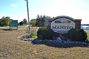
Manito sign on north side of town
|
|

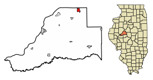
Location in Mason County, Illinois
|
|
| Country | United States |
| State | Illinois |
| County | Mason |
| Township | Manito |
| Area | |
| • Total | 1.51 sq mi (3.92 km2) |
| • Land | 1.51 sq mi (3.92 km2) |
| • Water | 0.00 sq mi (0.00 km2) |
| Elevation | 495 ft (151 m) |
| Population
(2020)
|
|
| • Total | 1,552 |
| • Density | 1,025.78/sq mi (396.14/km2) |
| Time zone | UTC-6 (CST) |
| • Summer (DST) | UTC-5 (CDT) |
| ZIP code |
61546
|
| Area code(s) | 309 |
| FIPS code | 17-46383 |
| GNIS ID | 2399241 |
| Wikimedia Commons | Manito, Illinois |
Manito is a small village located in Mason County, Illinois, United States. In 2020, about 1,552 people lived there. This was a slight decrease from 1,642 people in 2010.
Contents
Where is Manito Located?
Manito is in the northeastern part of Mason County. Its northern edge touches the border of Tazewell County. The village is about 5 miles (8 km) northeast of Forest City. It is also about 20 miles (32 km) northeast of Havana, which is the main town of Mason County. If you travel southwest for about 27 miles (43 km), you will reach Peoria.
According to the U.S. Census Bureau, Manito covers a total area of about 1.51 square miles (3.92 square kilometers). All of this area is land.
How Many People Live in Manito?
| Historical population | |||
|---|---|---|---|
| Census | Pop. | %± | |
| 1870 | 375 | — | |
| 1880 | 434 | 15.7% | |
| 1890 | 444 | 2.3% | |
| 1900 | 561 | 26.4% | |
| 1910 | 696 | 24.1% | |
| 1920 | 758 | 8.9% | |
| 1930 | 711 | −6.2% | |
| 1940 | 776 | 9.1% | |
| 1950 | 869 | 12.0% | |
| 1960 | 1,093 | 25.8% | |
| 1970 | 1,334 | 22.0% | |
| 1980 | 1,869 | 40.1% | |
| 1990 | 1,711 | −8.5% | |
| 2000 | 1,733 | 1.3% | |
| 2010 | 1,642 | −5.3% | |
| 2020 | 1,552 | −5.5% | |
| U.S. Decennial Census | |||
In the year 2000, there were 1,733 people living in Manito. These people lived in 686 households, with 506 of them being families. The population density was about 1,126 people per square mile (435 people per square kilometer).
About 32.9% of the households had children under 18 years old. Most households, 61.8%, were married couples living together. About 22.0% of all households were made up of people living alone. Of those, 10.8% were people aged 65 or older living by themselves.
The average age of people in the village was 37 years old. About 25.0% of the population was under 18. About 13.8% of the population was 65 years or older.
Getting Around Manito
Manito has an airport nearby called Palmer Flying Service Airport. It used to be known as Manito Mitchell Airport. This airport is privately owned. It is located about 5 miles (8 km) north of the center of Manito. The airport is actually in Tazewell County.
Famous People from Manito
Many interesting people have come from Manito. Here are a few:
- Henry Alfred Clauser was a guitarist, songwriter, and engineer. He was featured on radio shows in Des Moines and Tulsa.
- Joseph E. Daily was born in Manito. He became the Chief Justice of the Illinois Supreme Court.
- Helen Heckman was a dancer who was also born in Manito.
- H. V. Porter was an important educator. He was also a member of the Naismith Memorial Basketball Hall of Fame.
See also
 In Spanish: Manito para niños
 | Jackie Robinson |
 | Jack Johnson |
 | Althea Gibson |
 | Arthur Ashe |
 | Muhammad Ali |


