
Manufahi Municipality facts for kids
Quick facts for kids
Manufahi
|
||
|---|---|---|
|
||

Landscape between Dili and Same
|
||
|
||

|
||
|
OpenStreetMap
|
||
| Country | ||
| Capital | Same | |
| Administrative posts |
|
|
| Area | ||
| • Total | 1,332.5 km2 (514.5 sq mi) | |
| Area rank | 6th | |
| Population
(2015 census)
|
||
| • Total | 53,691 | |
| • Rank | 11th | |
| • Density | 40.2934/km2 (104.360/sq mi) | |
| • Density rank | 11th | |
| Households (2015 census) | ||
| • Total | 9,023 | |
| • Rank | 11th | |
| Time zone | UTC+09:00 (TLT) | |
| ISO 3166 code | TL-MF | |
| HDI (2017) | 0.618 medium · 3rd |
|

Manufahi is one of the municipalities of East Timor. It is known in Portuguese as Município Manufahi and in Tetum as Munisípiu Manufahi. As of 2015, about 53,691 people live here. The municipality covers an area of 1,323 square kilometers. The main town and capital of Manufahi is Same.
Contents
What's in a Name? The Story of Manufahi
The name Manufahi comes from the Tetum words Maun Fahe, which means 'divided brothers'. This name comes from an old legend. The legend tells about a big fight between two related tribes or a group of siblings. Eventually, they decided to live peacefully under one ruler.
During the time when Portuguese ruled East Timor, this area was called Same, after its main town. The name Manufahi was chosen later, based on the 'divided brothers' legend. However, it was misspelled. The misspelled name in Tetum actually means 'pig chicken'.
There are efforts to fix the name. Interestingly, another legend from the suco (a type of village) of Daisula tells a fun story. It says a rooster once flew from a mountain and landed on a pig's back. The rooster and pig then traveled to many places together before returning home.
Where is Manufahi? Geography and Borders
Manufahi is located in the central highlands of East Timor. It stretches all the way down to the south coast, touching the Timor Sea.
It shares borders with other important areas. To the east, it borders Manatuto. To the west, you'll find Ainaro. And to the north, it borders Aileu.
A Look Back: Manufahi's History
When East Timor was a Portuguese colony, the area now known as Manufahi was called Same. This was because Same was its main city.
Manufahi was a very important place during the Great Rebellion of 1910–12. This was a major uprising against Portuguese rule.
Later, during the time when Indonesia occupied East Timor, some changes were made to the administrative areas. The area known as Hato-Udo was moved from Manufahi to Ainaro. At the same time, the area of Turiscai, which used to be part of Ainaro, was moved to Manufahi.
How Manufahi is Organized: Administrative Posts
Manufahi is divided into smaller parts called administrative posts. These used to be called sub-districts. They help manage the different areas within the municipality.
The administrative posts of Manufahi are:
- Alas
- Fatuberlio
- Same
- Turiscai
People and Languages: Demographics
In Manufahi, people speak the national official languages of Tetum and Portuguese. Besides these, many people also speak Mambai. Mambai is a Malayo-Polynesian language that is also spoken in other parts of East Timor.
See also
 In Spanish: Distrito de Manufahi para niños
Images for kids
-
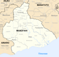
Administrative posts of Manufahi
-
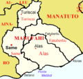
Cities of Manufahi


