
Ainaro Municipality facts for kids
Quick facts for kids
Ainaro
|
||
|---|---|---|
|
||

Maubisse village
|
||
|
||

|
||
|
OpenStreetMap
|
||
| Country | ||
| Capital | Ainaro | |
| Administrative posts | Ainaro, Hato-Udo, Hatu-Builico, Maubisse | |
| Area | ||
| • Total | 802.6 km2 (309.9 sq mi) | |
| Area rank | 9th | |
| Population
(2015 census)
|
||
| • Total | 63,136 | |
| • Rank | 10th | |
| • Density | 78.664/km2 (203.740/sq mi) | |
| • Density rank | 6th | |
| Households (2015 census) | ||
| • Total | 10,601 | |
| • Rank | 9th | |
| Time zone | UTC+09:00 (TLT) | |
| ISO 3166 code | TL-AN | |
| HDI (2017) | 0.560 medium · 12th |
|

Ainaro (also called Município Ainaro in Portuguese and Munisípiu Ainaru in Tetum) is one of the 13 main areas, or municipalities, in East Timor. It's located in the southwest part of the country. Ainaro is home to about 63,136 people (based on the 2015 census) and covers an area of 802.6 square kilometers. The main city and capital of this municipality is also called Ainaro, which is a small town nestled in the mountains.
Contents
What's in a Name? (Etymology)
The name "Ainaro" comes from the local Mambai language. It means "tall tree" and refers to a special type of tree that grows in this region. The name Ainaro is how the Portuguese say Ainaru, which is the Mambai and Tetum version.
The area also has an old traditional name, 'Orluli'. People still use this name today during special events. For example, during a ceremony called sergala, it's used to welcome important guests.
Geography and Nature
Ainaro is a beautiful place with many rivers and rich, fertile land. This makes it great for farming. It has a part that touches the Timor Sea on the coast. But it also has high mountains.
One of these mountains is Ramelau, which is also known as Tatamailau. It's the highest point in all of East Timor, standing at 2,960 meters (about 9,711 feet) tall! Mount Ramelau is located near the border with the Ermera area.
The borders of Ainaro municipality are mostly the same as they were when East Timor was a Portuguese colony. However, there were some changes during the time Indonesia occupied the country. For example, the Turiscai area moved to Manufahi. In return, the Hato-Udo area became part of Ainaro. Also, the Mape-Zumalai area moved to Cova Lima in 2003.
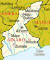
Ainaro shares its borders with several other municipalities:
- To the north, it borders Aileu.
- To the south, it borders Manufahi.
- To the southwest, it borders Cova Lima.
- To the west, it borders Bobonaro.
- To the northwest, it borders Ermera.
A Look at History
Ainaro played an important part during the time Indonesia occupied East Timor. It was a safe place for the guerrilla resistance army, who fought from the mountains. Xanana Gusmão, who was a leader of the resistance and later became a President and Prime Minister, spent many years guiding the resistance from Ainaro.
Administrative Areas
The municipality of Ainaro is divided into smaller administrative areas. These used to be called sub-districts. They are:
- Ainaro administrative post (where the capital city of Ainaro is located)
- Hato-Udo Administrative Post
- Hatu-Builico Administrative Post
- Maubisse Administrative Post
People and Languages
Most people in Ainaro speak Mambai as their first language, about 62.4%. About 29.1% speak Tetum, and 7.5% speak Bunak. There are also about 400 people who speak Kemac.
When it comes to religion, most people in Ainaro are Catholic, making up 99.1% of the population. A small number, 0.9%, are Protestants. Only a very small number of people, about 19, still follow traditional beliefs (based on the 2015 census).
Images for kids
-
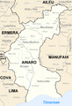
Borders of Ainaro before 2003
-
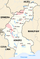
Borders of Ainaro after 2003
-
Cities and rivers of Ainaro


See also
 In Spanish: Distrito de Ainaro para niños
