Marble Rock, Iowa facts for kids
Quick facts for kids
Marble Rock, Iowa
|
|
|---|---|
| Motto(s):
Bike to Marble Rock for a 'Marbleous' Time!
|
|

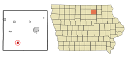
Location of Marble Rock, Iowa
|
|
| Country | |
| State | |
| County | Floyd |
| Area | |
| • Total | 0.87 sq mi (2.25 km2) |
| • Land | 0.83 sq mi (2.16 km2) |
| • Water | 0.04 sq mi (0.10 km2) |
| Elevation | 1,001 ft (305 m) |
| Population
(2020)
|
|
| • Total | 271 |
| • Density | 325.72/sq mi (125.72/km2) |
| Time zone | UTC-6 (Central (CST)) |
| • Summer (DST) | UTC-5 (CDT) |
| ZIP code |
50653
|
| Area code(s) | 641 |
| FIPS code | 19-49305 |
| GNIS feature ID | 0458797 |
Marble Rock is a small city in Floyd County, Iowa, United States. It is located right next to the Shell Rock River. In 2020, about 271 people lived there.
Marble Rock has fun places like a city park and historical museums. You can also see a powerhouse on the river and a special memorial for veterans. The Marble Rock Historical Society has a website with more information about the museums.
Contents
Exploring Marble Rock's Location
Marble Rock is found at a specific spot on the map: 42.964695 degrees North and 92.867786 degrees West. The city got its name because there is a lot of white limestone in the area. This type of rock looks a bit like marble.
The Shell Rock River flows along the west side of town. It's a great spot for people who enjoy fishing or using small boats. If you like canoeing, there's a special path called a portage around the dam on the west side of the river. This lets you easily move your canoe past the dam.
How Big is Marble Rock?
The United States Census Bureau says that Marble Rock covers a total area of about 0.87 square miles (2.25 square kilometers). Most of this area, about 0.83 square miles (2.16 square kilometers), is land. The rest, about 0.04 square miles (0.10 square kilometers), is water.
Understanding Marble Rock's Population
The number of people living in Marble Rock has changed over many years. Here's a quick look at how the population has grown and shrunk:
| Historical populations | ||
|---|---|---|
| Year | Pop. | ±% |
| 1880 | 409 | — |
| 1890 | 433 | +5.9% |
| 1900 | 573 | +32.3% |
| 1910 | 480 | −16.2% |
| 1920 | 483 | +0.6% |
| 1930 | 441 | −8.7% |
| 1940 | 660 | +49.7% |
| 1950 | 470 | −28.8% |
| 1960 | 442 | −6.0% |
| 1970 | 461 | +4.3% |
| 1980 | 419 | −9.1% |
| 1990 | 361 | −13.8% |
| 2000 | 326 | −9.7% |
| 2010 | 307 | −5.8% |
| 2020 | 271 | −11.7% |
| Source: and Iowa Data Center Source: |
||
What the 2020 Census Shows
In 2020, the United States census counted 271 people living in Marble Rock. There were 126 households, which are like homes where people live. About 76 of these households were families.
Most people in the city, about 98.9%, were White. A very small number, 1.1%, were from two or more racial backgrounds. About 0.4% of the population identified as Hispanic or Latino.
The average age of people in Marble Rock was 46.3 years old. About 24.4% of the residents were under 20 years old. This means there are quite a few young people in the city!
What the 2010 Census Showed
Back in 2010, the census counted 307 people living in Marble Rock. There were 134 households. Most people were White, about 99.0%.
About 27.6% of the households had children under 18 living with them. The average age in the city was 47.5 years. About 21.8% of the residents were under 18 years old.
Learning in Marble Rock
The Rudd-Rockford-Marble Rock Community School District is in charge of the public schools in the Marble Rock area. This district makes sure that students living in and around Marble Rock get their education.
See also
 In Spanish: Marble Rock (Iowa) para niños
 | Madam C. J. Walker |
 | Janet Emerson Bashen |
 | Annie Turnbo Malone |
 | Maggie L. Walker |

