March Route of Rochambeau's Army: Plainfield Pike facts for kids
|
March Route of Rochambeau's Army: Plainfield Pike
|
|

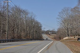
the march route along Plainfield Pike, in 2016
|
|
| Nearest city | Plainfield, Connecticut |
|---|---|
| Area | 22 acres (8.9 ha) |
| MPS | Rochambeau's Army in Connecticut, 1780-1782 MPS |
| NRHP reference No. | 03000312 |
Quick facts for kids Significant dates |
|
| Dates of significance | 1781, 1782 |
| Added to NRHP | June 6, 2003 |
The March Route of Rochambeau's Army: Plainfield Pike is a special road segment in Plainfield and Sterling, Connecticut. It stretches for about 3.6 miles. This road was a key part of a historic journey during the American Revolution.
In June 1781, the French army, led by General Rochambeau, marched along this path. They were on their way to Yorktown, Virginia, for a very important battle. The army used this same road again in November 1782 when they returned. Because of its historical importance, this section of the road was added to the National Register of Historic Places in 2003.
The Historic Plainfield Pike March Route
This historic road is part of what is now Connecticut Route 14A. It is known locally as Plainfield Pike. The road is mostly flat in its eastern part but becomes hilly and curvy further west.
Along the route, you can see open fields, like pastures and cornfields. There are also wooded areas and small streams, including Ekonk Brook. Stone walls border both sides of the road for most of its length. These walls are usually about 50 feet apart.

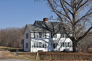
In some parts, especially during certain times of the year, these old stone walls are very clear to see. However, they can be hidden by overgrown plants in the summer. One important spot along the route is the Sterling Hill Historic District. Here, you can find houses built in the 1700s and 1800s.
A famous building along this route is the Dorrance Inn in Sterling. This inn was mentioned in several French soldiers' journals from the time of the marches. It is also listed on the National Register of Historic Places.
What the Soldiers Saw
As the troops marched through in 1781 and 1782, they would have seen many farm fields and open countryside. The views today still look similar to how they did back then. You can even see distant ridges to the west, across the Quinebaug River valley.
Experts say that even though it's a paved state highway now, the road still feels narrow, hilly, and winding. The old stone walls are still there for most of its length. This is the longest part of the original route that still looks much like it did back then. It's also the only section that still offers clear views of distant ridges. In other places, new forests have grown, blocking these views.
A Challenging Journey
When Rochambeau's army marched in 1781, the road was in poor condition. Especially to the east of Plainfield, the road was very difficult. This caused problems for the army's artillery (cannons) and baggage wagons. They had trouble making their way to the camp in Plainfield from their previous stop in Rhode Island.
French soldiers wrote about these difficulties in their journals. One soldier, Clermont-Crevecoeur, wrote that the roads were "very bad." He noted that the artillery and supply wagons arrived "very late" at the Plainfield camp. Another soldier, Von Closen, agreed, saying, "The roads were still very bad." Du Bourg also mentioned, "The roads still quite bad, many stragglers." This shows how tough the journey was for the soldiers.
 | Misty Copeland |
 | Raven Wilkinson |
 | Debra Austin |
 | Aesha Ash |


