Margery Hill facts for kids
Quick facts for kids Margery Hill |
|
|---|---|

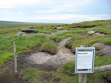
Margery Hill cairn
|
|
| Highest point | |
| Elevation | 546 m (1,791 ft) |
| Prominence | 19 m |
| Parent peak | Kinder Scout |
| Geography | |
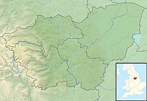
| Location | South Yorkshire, England |
| Parent range | Peak District |
| OS grid | SK189956 |
Margery Hill is a cool hill in South Yorkshire, England. It stands about 546 meters (1,791 feet) tall. You can find it in the northern part of the amazing Peak District National Park.
This hill is located between two reservoirs: Langsett Reservoir to the northeast and Howden Reservoir to the southwest. The National Trust looks after this area as part of their High Peak Estate. They help protect its natural beauty.
Exploring Margery Hill
Margery Hill is a great place to explore the outdoors. It's part of the Howden Moors, which are wide, open spaces perfect for hiking. The views from the top are fantastic!
Ancient Secrets of the Hill
Near the top of Margery Hill, there's a pile of stones called a cairn. Scientists have studied the ground around it. They found that the peat (a type of soil made from old plants) near the cairn is about 3,500 years old. This tells us that the cairn was built by people, not formed naturally.
People believe this cairn was once part of a Bronze Age burial mound. This means it was an ancient burial place from the Bronze Age, a time long ago when people used bronze tools. Because of its history, Margery Hill has been named a Scheduled Ancient Monument by English Heritage. This means it's a very important historical site that is protected by the government.
Sheffield's Highest Point
Did you know that Margery Hill is the highest marked point within the city boundaries of Sheffield? While the land rises a tiny bit higher (to 548 meters or 1,798 feet) about 1.5 kilometers (0.9 miles) to the south, near a place called High Stones, Margery Hill is the official highest point marked on maps for Sheffield.
 | Janet Taylor Pickett |
 | Synthia Saint James |
 | Howardena Pindell |
 | Faith Ringgold |


