Marlboro (CDP), New Jersey facts for kids
Quick facts for kids
Marlboro, New Jersey
|
|
|---|---|
| Country | |
| State | |
| County | Cumberland |
| Township | Stow Creek |
| Area | |
| • Total | 0.39 sq mi (1.00 km2) |
| • Land | 0.39 sq mi (1.00 km2) |
| • Water | 0.00 sq mi (0.00 km2) |
| Elevation | 117 ft (36 m) |
| Population
(2020)
|
|
| • Total | 127 |
| • Density | 329.87/sq mi (127.20/km2) |
| Time zone | UTC−05:00 (Eastern (EST)) |
| • Summer (DST) | UTC−04:00 (EDT) |
| ZIP Code |
08302 (Bridgeton)
|
| Area code(s) | 856 |
| FIPS code | 34-44010 |
| GNIS feature ID | 2806123 |
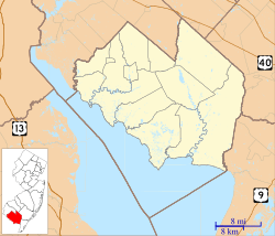
Marlboro is a small community in Stow Creek Township, New Jersey. It is located on the northwestern edge of Cumberland County. Marlboro is known as a "census-designated place" (CDP). This means it's an area that the government counts for population numbers, even though it's not an official town or city.
About Marlboro
Marlboro is a quiet area that includes the small communities of Marlboro and Campbells Corner. It is bordered by Quinton Township in Salem County to the northwest. A small stream called Sarah Run separates the two areas.
Getting Around Marlboro
New Jersey Route 49 is an important road that goes through Marlboro. If you travel southeast on this road for about 6 miles (10 km), you will reach Bridgeton. Bridgeton is the main town, or county seat, of Cumberland County. If you go northwest on Route 49 for about 10 miles (16 km), you will arrive in Salem.
How Many People Live Here?
The government first officially listed Marlboro as a CDP before the 2020 census. According to the 2020 census, the population of Marlboro was 127 people.
| Historical population | |||
|---|---|---|---|
| Census | Pop. | %± | |
| 2020 | 127 | — | |
| U.S. Decennial Census 2020 |
|||
 | James Van Der Zee |
 | Alma Thomas |
 | Ellis Wilson |
 | Margaret Taylor-Burroughs |


