Marple Junction facts for kids
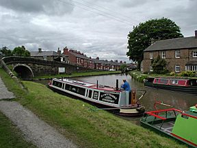
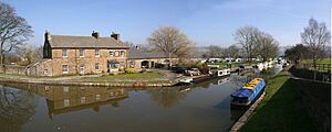
Marple Junction is a special spot where two canals meet! It's where the Macclesfield Canal ends and joins the Peak Forest Canal. You can find it in Marple, Greater Manchester, England.
Long ago, a special 'stop lock' kept the water from the two canals separate. But now, the lock gates are gone, and the water levels are the same. This means boats can easily move between them.
Contents
A Look Back: How the Canals Began
The Peak Forest Canal got permission to be built in 1794. This permission came from an Act of Parliament, which is like a special law passed by the government. The canal was built to help transport limestone from places like Doveholes, near Whaley Bridge.
It stretched from Dukinfield Junction to Bugsworth Basin. From Bugsworth, a special railway (called a tramway) carried the limestone about 6.5 miles (10.5 km) up to the quarries. These quarries were very high up, over 1,000 feet (305 meters) above sea level!
The canal had two flat sections of water. These were separated by 16 locks. These locks lifted boats up by 214 feet (65 meters). Most of the canal opened in 1800. However, the locks weren't finished until 1804. For a while, another tramway was used to bypass the locks.
The Macclesfield Canal's Story
People first thought about building a canal through Macclesfield in 1777. This canal would connect the Trent and Mersey Canal to Manchester. But it wasn't until 1826 that a special law was passed to build it. This happened after a survey by a famous engineer named Thomas Telford.
The Macclesfield Canal officially opened on November 9, 1831. Like the Peak Forest Canal, it also had two flat sections of water. These were separated by a set of twelve locks called the Bosley locks. These locks raised the water level by 118 feet (36 meters). Marple Junction is located just above the top lock of the Marple flight of locks.
Bringing the Canals Back to Life
The limestone traffic on the upper part of the Peak Forest Canal stopped in 1922. Slowly, that section became unusable. The lower part of the canal was also not used much by 1939.
But many groups worked hard to save the canals! These included the Peak Forest Canal Society, the Inland Waterways Association, and the British Waterways Board. Local councils also helped. Because of their efforts, both the Peak Forest and Ashton Canals reopened in 1974. This meant Marple Junction was connected to the national canal network again. It became a busy junction once more!
Where Marple Junction Is Today
The top lock of the Marple flight is right next to the junction, to the north. From the bottom of these locks, the canal goes through Hyde Bank Tunnel and Woodley Tunnel. It then reaches Dukinfield Junction, about 8 miles (13 km) away.
To the south-east, the canal is flat for about 6.7 miles (10.8 km). It ends at Bugsworth Basin, which has been restored by the Bugsworth Basin Heritage Trust.
The Macclesfield Canal first heads south-west from the junction. Then it turns south. A footbridge helps people cross from one side of the Peak Forest Canal to the Macclesfield Canal. But it quickly crosses back to the western bank of the Macclesfield Canal at Church Lane Bridge.
This canal is flat for a long stretch, about 16.1 miles (25.9 km), until it reaches the top of the Bosley locks. It continues on to Hall Green stop lock, where it meets the Trent and Mersey Canal. That's about 26.1 miles (42 km) from the junction.
The entire Macclesfield Canal is a special conservation area. This happened in June 1975. It was part of a plan to help people enjoy Britain's canals for fun activities.
 | Anna J. Cooper |
 | Mary McLeod Bethune |
 | Lillie Mae Bradford |


