
Mary le Port Street, Bristol facts for kids

Mary le Port Street after the 24 November 1940 bombing raid, showing the remains of the church from the south east. Other bombed buildings and the tower of All Saints' Church are also visible.
|
|

Location in Bristol Central
|
|
| Maintained by | Bristol City Council |
|---|---|
| Location | Bristol, England |
| Postal code | BS1 |
| Coordinates | 51°27′17″N 2°35′29″W / 51.4548°N 2.5915°W |
| East | Peter Street |
| West | High Street |
Mary le Port Street was a very old and important street in Bristol, England. It was also known as St Mary le Port Street, Maryleport Street, or Maryport Street. This street connected the area around St Peter's Church and Bristol Castle with the older part of the town. This older part included streets like High Street, Wine Street, Corn Street, and Broad Street.
In 1940, the street was badly damaged by bombs during World War II. After the war, it became just an unnamed path for service vehicles and people walking. However, recent plans for Bristol want to bring Mary le Port Street back. The goal is to improve the connection between the Broadmead shopping area and the St Nicholas Market area.
Contents
History of Mary le Port Street
Mary le Port Street started as an old sunken path even before the Normans came to England in 1066. Digs in 1962 and 1963 found signs of activity from the late Saxon period. They even found parts of a timber building from that time. Later, around the 1200s, this sunken path was filled in and paved. The materials for paving might have come from digging out cellars nearby.
The Church of St Mary le Port
St Mary le Port Church was likely built during Saxon times. Over the years, it was made bigger and rebuilt. It reached its largest size and best design in the 1400s.
What the Street Looked Like
In the 1920s, a writer named Charles Wells described Mary le Port Street. He said the old houses hung out so far that people could shake hands from windows across the street! Most of these old houses were replaced by newer, more useful buildings. But a few of the very old ones were still there. Wells also mentioned that the church was "hidden" by these old shops. He said the best view of the church was from its churchyard behind it.
Another writer, J. B. Priestley, visited Bristol in 1933. He was very impressed by Mary le Port Street. He wrote that Bristol was special because it was both old and lively. It wasn't just a "museum piece" that only cared about tourists. He loved the "fantastic little old thoroughfares like Mary-Le-Port Street". He felt Bristol showed off its history but was still a busy, real city.
Damage from World War II
Sadly, Mary le Port Street and the old streets around it were almost completely destroyed. This happened during the Bristol Blitz on the night of November 24, 1940. Bombs caused a lot of damage to the area.
After the War
After the war, there were plans to build a new Civic Centre in the area. This would have included an art gallery, museum, hotel, and exhibition center. But these plans never happened. Instead, the land on both sides of Mary le Port Street was rented out. The Bank of England and the Norwich Union Insurance Company built offices there. Their buildings are now empty.
Mary le Port Street Today
Mary le Port Street is no longer on maps. Its paved road was removed in October 1963. The remains of St Mary le Port Church are now a protected historical site. The church tower is also a listed building, meaning it's important and protected.
Plans for the Future
In 2018, Bristol City Council decided they wanted to bring this street back. They said it was important to create a main path for people walking. This path would link St Nicholas Market to St Peter's Church. They also want to build new buildings that fit well with the church.
In 2020, the land was sold to a company called Federated Hermes. The developer, MEPC, said they plan to create a "memorable and distinctive place." They want to bring back the old streets and paths that were there before World War II.
The area where Mary le Port Street used to be is part of a special protected zone. This zone is called the Old City and Queen Square Conservation Area. This means any new building or changes must respect the area's history and look.
Gallery
-
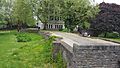
Remains of Mary le Port Street, looking towards High Street from St Peter's Church
-
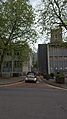
Looking across High Street into the former Mary le Port Street; tower of church is visible on right
-
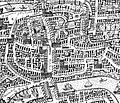
Millerd's Map of 1671, showing Mary le Port Street and Church


