Matchwood Township, Michigan facts for kids
Quick facts for kids
Matchwood Township, Michigan
|
|
|---|---|

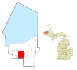
Location within Ontonagon County
|
|
| Country | United States |
| State | Michigan |
| County | Ontonagon |
| Area | |
| • Total | 109.53 sq mi (283.7 km2) |
| • Land | 109.52 sq mi (283.7 km2) |
| • Water | 0.01 sq mi (0.03 km2) |
| Elevation | 1,257 ft (383 m) |
| Population
(2020)
|
|
| • Total | 90 |
| • Density | 0.86/sq mi (0.33/km2) |
| Time zone | UTC-5 (Eastern (EST)) |
| • Summer (DST) | UTC-4 (EDT) |
| ZIP code(s) | |
| Area code(s) | 906 |
| FIPS code | 26-52320 |
| GNIS feature ID | 1626709 |
Matchwood Township is a small community located in Ontonagon County, in the state of Michigan, United States. It is known as a civil township, which is a type of local government area. In 2020, about 90 people lived here.
Contents
Where is Matchwood Township?
Matchwood Township is located in the Upper Peninsula of Michigan. It covers a total area of about 109.53 square miles (283.68 square kilometers). Most of this area, 109.52 square miles (283.65 square kilometers), is land. Only a tiny part, 0.01 square miles (0.03 square kilometers), is water.
The Community of Matchwood
Within Matchwood Township, there is a small place called Matchwood. It is an unincorporated community, which means it doesn't have its own local government like a city or town. It is located on M-28, a main road. This spot is about 6 miles west of Ewen and 9 miles east of Bergland.
History of Matchwood Community
The community of Matchwood got its name from the Diamond Match Company. This company owned many of the pine forests in the area. In 1888, the company started the settlement to support its logging camps. These camps were where workers lived while cutting down trees.
Matchwood received its own Post Office in 1889, which helped connect it to other places. However, the community faced challenges. In 1893, a large forest fire nearly destroyed it. The people rebuilt their homes and businesses. But sadly, another big fire ruined the community again in 1906. Despite these difficulties, the Duluth, South Shore and Atlantic Railway (now known as the Soo Line Railroad) passed through Matchwood, which was important for transporting goods and people.
See also
 In Spanish: Municipio de Matchwood para niños


