Maybrook, New York facts for kids
Quick facts for kids
Maybrook
|
|
|---|---|

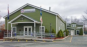
Maybrook village hall in 2015
|
|

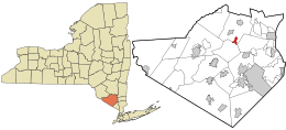
Location of Orange County, New York (left) and of Maybrook in Orange County (right)
|
|

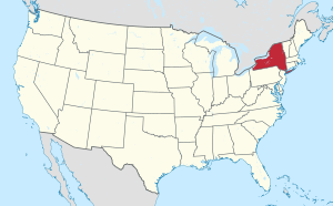
Location of New York state in the United States
|
|
| Country | United States |
| State | New York |
| County | Orange |
| Founded | 1926 |
| Area | |
| • Total | 1.36 sq mi (3.52 km2) |
| • Land | 1.35 sq mi (3.51 km2) |
| • Water | 0.01 sq mi (0.01 km2) |
| Elevation | 420 ft (130 m) |
| Highest elevation
(Unnamed hill near west village line)
|
520 ft (160 m) |
| Lowest elevation
(Swampy area in northeast corner)
|
360 ft (110 m) |
| Population
(2020)
|
|
| • Total | 3,150 |
| • Density | 2,326.44/sq mi (898.09/km2) |
| Time zone | UTC-5 (Eastern (EST)) |
| • Summer (DST) | UTC-4 (EDT) |
| ZIP Code |
12543
|
| Area code(s) | 845 |
| FIPS code | 36-46162 |
| GNIS feature ID | 0956701 |
| Wikimedia Commons | Maybrook, New York |
Maybrook is a small village in Orange County, New York, in the United States. About 3,150 people lived there in 2020. It's part of a larger area that includes cities like Poughkeepsie, Newburgh, and Middletown.
Most of Maybrook is in the town of Montgomery. A small part is in the town of Hamptonburgh. It has its own phone area code (845) and ZIP code (12543). The village also has its own fire department.
Contents
Geography: Where is Maybrook?
Maybrook is located at 41°29′12″N 74°12′52″W / 41.48667°N 74.21444°W.
The village covers about 1.3 square miles (3.5 square kilometers) of land. The main road, NY 208, runs through the village. It goes from the southwest to the northeast for about two miles (3.2 kilometers).
Maybrook is mostly flat. However, there are some hills on its western side. The highest point is about 520 feet (158 meters) above sea level. The lowest point is a swampy area in the northeast corner, about 360 feet (110 meters) high.
Stewart Dairy Farm and Airport Expansion
In 1930, Thomas "Archie" Stewart was interested in aviation. He convinced his uncle, Samuel Stewart, to give some land called "Stoney Lonesome" to the city of Newburgh. This land was used to create an airport.
In the early 1970s, Governor Nelson Rockefeller thought Stewart Airport could become a major airport. Its long runway was perfect for new supersonic planes. The Metropolitan Transportation Authority tried to make it New York City's fourth big airport. They greatly expanded the airport's land. The state used its power to buy about 7,500 acres (3,000 hectares) of land. This land was for new terminals, runways, and a buffer zone. The airport expanded from Newburgh into the nearby towns of Montgomery and Hamptonburgh.
Population: Who Lives in Maybrook?
| Historical population | |||
|---|---|---|---|
| Census | Pop. | %± | |
| 1930 | 1,159 | — | |
| 1940 | 1,189 | 2.6% | |
| 1950 | 1,316 | 10.7% | |
| 1960 | 1,348 | 2.4% | |
| 1970 | 1,536 | 13.9% | |
| 1980 | 2,007 | 30.7% | |
| 1990 | 2,802 | 39.6% | |
| 2000 | 3,084 | 10.1% | |
| 2010 | 2,958 | −4.1% | |
| 2020 | 3,150 | 6.5% | |
| U.S. Decennial Census | |||
In 2000, there were 3,084 people living in Maybrook. There were 1,043 households, which are groups of people living together. About 780 of these were families. The village had about 2,306 people per square mile (891 people per square kilometer).
Most people in Maybrook were white (82.81%). About 8.98% were African American, and 1.2% were Asian. About 12.74% of the population was Hispanic or Latino.
Many households (46.3%) had children under 18 living with them. About 54.3% were married couples. Around 14.7% were single mothers with no husband. About 25.2% were not families.
The average household had 2.95 people. The average family had 3.41 people.
The population was spread out by age. About 32.7% were under 18. About 32.8% were between 25 and 44 years old. The average age was 32 years. For every 100 females, there were about 95 males.
In 2000, the average income for a household in Maybrook was $52,872 per year. For families, it was $56,912. The average income per person was $19,194. About 6.1% of all people in the village lived below the poverty line. This included 6.9% of those under 18.
History: How Maybrook Grew
Maybrook became an official village in 1926. It was the last of the three villages in the town of Montgomery to be created.
The village grew because of the Maybrook Yard. This was a very important switching terminal for trains. Trains from several railroads would come here. Then, they would cross the Poughkeepsie Bridge to go east. At its busiest, the Maybrook Yard had over 1,500 workers.
However, the Poughkeepsie Bridge closed in 1974. After that, all the train yards and buildings were removed. Today, there is still some freight train service to Maybrook. This service is provided by the Middletown and New Jersey Railroad.
Transportation: Getting Around Maybrook
Maybrook is easy to reach by major roads like Interstate 84 and the New York State Thruway. It is also close to Stewart International Airport. New York State Route 208 is the main road that goes through the center of the village.
A large shipping company called Yellow Freight used to have a center in Maybrook. It was located on a big part of the old train yard. However, this company stopped operating in 2023.
You can also get to Maybrook by train. The Campbell Hall station is about 5.4 miles (8.7 kilometers) away. It is on the Metro-North Railroad's Port Jervis Line. The Beacon station is about 16.1 miles (25.9 kilometers) to the east. It is on the Hudson Line.
Education: Maybrook Schools
Most of the village of Maybrook is part of the Valley Central School District (Montgomery). A small part of the village is in the Washingtonville Central School District.
See also
 In Spanish: Maybrook para niños
 | William Lucy |
 | Charles Hayes |
 | Cleveland Robinson |


