Mayo River (Dan River tributary) facts for kids
Quick facts for kids Mayo River |
|
|---|---|
|
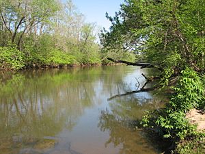
Mayo River at US 220 access
|
|
|
Location of Mayo River mouth
|
|
| Other name(s) | Tributary to Dan River |
| Country | United States |
| State | North Carolina |
| County | Rockingham |
| City | Mayodan |
| Physical characteristics | |
| Main source | confluence of North and South Mayo Rivers about 6 miles northeast of Ayersville, North Carolina 698 ft (213 m) 36°32′25″N 078°59′21″W / 36.54028°N 78.98917°W |
| River mouth | Dan River Madison, North Carolina 538 ft (164 m) 36°23′24″N 078°57′07″W / 36.39000°N 78.95194°W |
| Length | 15.58 mi (25.07 km) |
| Basin features | |
| Progression | south-southeast |
| River system | Dan River |
| Basin size | 317.50 square miles (822.3 km2) |
| Tributaries |
|
| Bridges | Anglin Mill Road, T. Clarence Stone Highway, US 220, JJ Webster Highway, Dan Valley Road |
The Mayo River is a smaller river that flows into a bigger one, called a tributary. It flows into the Dan River, which then flows into the Roanoke River. All three of these rivers run through the United States states of Virginia and North Carolina. The Mayo River was named after Major William Mayo, who lived around 1685 to 1744.
Where the Mayo River Flows
The Mayo River actually starts as two main parts: the North Fork Mayo River and the South Fork Mayo River. Both of these parts begin in Patrick County, Virginia. As they flow, they collect water from many smaller streams.
These two parts then join together in the northwestern part of Rockingham County, North Carolina. This is where the Mayo River officially begins. From there, it flows south until it meets the Dan River. This meeting point is close to the towns of Mayodan, North Carolina and Madison, North Carolina.
 | Isaac Myers |
 | D. Hamilton Jackson |
 | A. Philip Randolph |


