McAfee Peak facts for kids
Quick facts for kids McAfee Peak |
|
|---|---|

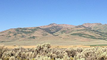
View of McAfee Peak from North Fork Road
|
|
| Highest point | |
| Elevation | 10,442 ft (3,183 m) NAVD 88 |
| Prominence | 4,158 ft (1,267 m) |
| Geography | |
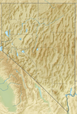
| Location | Elko County, Nevada, U.S. |
| Parent range | Independence Mountains |
| Topo map | USGS McAfee Peak |
| Climbing | |
| Easiest route | From Jacks Creek Summit, Class 2 scramble south along the ridgeline |
McAfee Peak is a tall mountain located in northern Elko County, Nevada, in the United States. It is the highest point in the Independence Mountains. This makes it a very important peak in the area.
McAfee Peak is also known for its "prominence." This means it stands out a lot from the land around it. It is the twenty-first most prominent peak in all of Nevada. The mountain is part of the Humboldt-Toiyabe National Forest, a large area of protected land.
Exploring McAfee Peak's Views
When you reach the top of McAfee Peak, you can see amazing views all around. From the summit, you get a full 360-degree look at the beautiful landscapes of Nevada. It's a great spot to see how vast and open the natural world is.
Black History Month on Kiddle
Distinguished African-American Artists:
 | Sharif Bey |
 | Hale Woodruff |
 | Richmond Barthé |
 | Purvis Young |

All content from Kiddle encyclopedia articles (including the article images and facts) can be freely used under Attribution-ShareAlike license, unless stated otherwise. Cite this article:
McAfee Peak Facts for Kids. Kiddle Encyclopedia.


