McFall, Missouri facts for kids
Quick facts for kids
McFall, Missouri
|
|
|---|---|

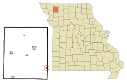
Location of McFall, Missouri
|
|
| Country | United States |
| State | Missouri |
| County | Gentry |
| Area | |
| • Total | 0.31 sq mi (0.80 km2) |
| • Land | 0.31 sq mi (0.80 km2) |
| • Water | 0.00 sq mi (0.00 km2) |
| Elevation | 984 ft (300 m) |
| Population
(2020)
|
|
| • Total | 119 |
| • Density | 387.62/sq mi (149.43/km2) |
| Time zone | UTC-6 (Central (CST)) |
| • Summer (DST) | UTC-5 (CDT) |
| ZIP code |
64657
|
| Area code(s) | 660 |
| FIPS code | 29-45020 |
| GNIS feature ID | 2395065 |
McFall is a small, quiet village in Missouri, United States. Even though it's a village, it's officially called a city under Missouri law because it's an incorporated community. This means it has its own local government. McFall is located in the southeastern part of Gentry County. In 2020, about 119 people lived there. The village has a post office, a city hall, and a fire department.
Contents
History of McFall
McFall was first established in 1879. It was named after John McFall Sr., who owned the land where the village was built. A post office has been serving the community since McFall was founded in 1879.
Where is McFall Located?
McFall is situated along Missouri Route T. It's right next to the border between Gentry County and Daviess County. If you travel about 10.5 miles northwest, you'll reach Albany. Going six miles southeast will take you to Pattonsburg in Daviess County. A natural area called the Elam Bend Conservation Area, located on the Grand River, is just three miles southwest of McFall.
The United States Census Bureau states that McFall covers a total area of about 0.31 square miles (0.80 square kilometers). All of this area is land.
Population Changes Over Time
| Historical population | |||
|---|---|---|---|
| Census | Pop. | %± | |
| 1880 | 115 | — | |
| 1890 | 528 | 359.1% | |
| 1900 | 544 | 3.0% | |
| 1910 | 385 | −29.2% | |
| 1920 | 447 | 16.1% | |
| 1930 | 387 | −13.4% | |
| 1940 | 393 | 1.6% | |
| 1950 | 255 | −35.1% | |
| 1960 | 206 | −19.2% | |
| 1970 | 203 | −1.5% | |
| 1980 | 139 | −31.5% | |
| 1990 | 142 | 2.2% | |
| 2000 | 135 | −4.9% | |
| 2010 | 93 | −31.1% | |
| 2020 | 119 | 28.0% | |
| U.S. Decennial Census | |||
The population of McFall has changed quite a bit over the years. In 1890, the village had 528 residents, which was its highest recorded population. By 2010, the population had decreased to 93 people. However, the most recent 2020 census showed a slight increase, with 119 people living in McFall.
Who Lives in McFall?
According to the census from 2010, there were 93 people living in McFall. All of the residents were identified as White. The average age of people in McFall was about 47.8 years old.
About 19.4% of the residents were under 18 years old. People aged 65 or older made up 31.2% of the population. The number of males and females was almost equal, with 50.5% male and 49.5% female residents.
See also
 In Spanish: McFall (Misuri) para niños
 | Jessica Watkins |
 | Robert Henry Lawrence Jr. |
 | Mae Jemison |
 | Sian Proctor |
 | Guion Bluford |

