Pattonsburg, Missouri facts for kids
Quick facts for kids
Pattonsburg, Missouri
|
|
|---|---|

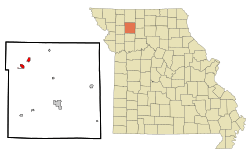
Location of Pattonsburg, Missouri
|
|
| Country | United States |
| State | Missouri |
| County | Daviess |
| Area | |
| • Total | 0.61 sq mi (1.57 km2) |
| • Land | 0.61 sq mi (1.57 km2) |
| • Water | 0.00 sq mi (0.00 km2) |
| Elevation | 860 ft (260 m) |
| Population
(2020)
|
|
| • Total | 314 |
| • Density | 518.15/sq mi (199.95/km2) |
| Time zone | UTC-6 (Central (CST)) |
| • Summer (DST) | UTC-5 (CDT) |
| ZIP code |
64670
|
| Area code(s) | 660 |
| FIPS code | 29-56558 |
| GNIS feature ID | 2396162 |
Pattonsburg is a small city located in the northwest part of Daviess County, Missouri, in the United States. In 2020, about 314 people lived there. It's a quiet place with an interesting past!
Contents
A Brief History of Pattonsburg
Pattonsburg wasn't always in its current spot. The original town, now called Old Pattonsburg, was about four miles south.
In 1993, a huge event called the Great Flood of 1993 hit the area. This flood caused a lot of damage to the old town. Because of this, the people of Pattonsburg decided to move the entire city to higher ground. This new location is where Pattonsburg stands today.
Where is Pattonsburg?
Pattonsburg is in the northwest part of Daviess County. You can find it just west of U.S. Route 69 and two miles west of I-35, which are major roads.
A stream called Big Creek flows east of the city. It eventually joins the Grand River a couple of miles to the southeast.
The city covers a total area of about 0.61 square miles (1.57 square kilometers). All of this area is land, meaning there are no large lakes or rivers within the city limits.
Who Lives in Pattonsburg?
The number of people living in Pattonsburg has changed over the years. Here's a quick look at the population from different census counts:
| Historical population | |||
|---|---|---|---|
| Census | Pop. | %± | |
| 1890 | 532 | — | |
| 1900 | 1,065 | 100.2% | |
| 1910 | 1,044 | −2.0% | |
| 1920 | 1,068 | 2.3% | |
| 1930 | 1,009 | −5.5% | |
| 1940 | 1,017 | 0.8% | |
| 1950 | 883 | −13.2% | |
| 1960 | 753 | −14.7% | |
| 1970 | 540 | −28.3% | |
| 1980 | 502 | −7.0% | |
| 1990 | 414 | −17.5% | |
| 2000 | 261 | −37.0% | |
| 2010 | 348 | 33.3% | |
| 2020 | 314 | −9.8% | |
| U.S. Decennial Census | |||
Pattonsburg in 2010
In 2010, the census counted 348 people living in Pattonsburg. There were 99 households and 59 families.
The city had a population density of about 570 people per square mile (220 people per square kilometer). This means that, on average, 570 people lived in every square mile of the city. There were also 118 housing units, like houses or apartments.
Most of the people living in Pattonsburg in 2010 were White (95.1%). A smaller number were African American (2.6%) or Native American (1.4%). About 0.9% of the population identified with two or more races. Around 2.9% of the people were Hispanic or Latino.
Out of the 99 households:
- 30.3% had children under 18 living with them.
- 47.5% were married couples living together.
- 8.1% had a female head of the household with no husband present.
- 4.0% had a male head of the household with no wife present.
- 40.4% were non-family households (meaning people living alone or with roommates, but not as a family).
The average household had 2.28 people, and the average family had 3.03 people.
The average age of people in Pattonsburg in 2010 was 34.2 years.
- 17.8% of residents were under 18 years old.
- 12.1% were between 18 and 24 years old.
- 34.2% were between 25 and 44 years old.
- 22.4% were between 45 and 64 years old.
- 13.5% were 65 years old or older.
More males lived in the city than females: 60.1% were male and 39.9% were female.
Images for kids
See also
 In Spanish: Pattonsburg (Misuri) para niños
 | Frances Mary Albrier |
 | Whitney Young |
 | Muhammad Ali |


