McLain, Mississippi facts for kids
Quick facts for kids
McLain, Mississippi
|
|
|---|---|

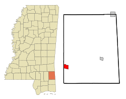
Location of McLain, Mississippi
|
|
| Country | United States |
| State | Mississippi |
| County | Greene |
| Area | |
| • Total | 3.45 sq mi (8.95 km2) |
| • Land | 3.39 sq mi (8.78 km2) |
| • Water | 0.06 sq mi (0.16 km2) |
| Elevation | 72 ft (22 m) |
| Population
(2020)
|
|
| • Total | 313 |
| • Density | 92.30/sq mi (35.63/km2) |
| Time zone | UTC-6 (Central (CST)) |
| • Summer (DST) | UTC-5 (CDT) |
| ZIP code |
39456
|
| Area code(s) | 601 |
| FIPS code | 28-43840 |
| GNIS feature ID | 0693928 |
McLain is a small town in Greene County, Mississippi. In 2010, about 441 people lived there. The population was 313 in 2020.
Contents
McLain's History
Natural Disasters in McLain
McLain has faced some tough natural events. In spring 2016, the town had big floods. These floods closed many roads and even the local school.
Later, on March 30, 2022, a strong tornado hit McLain. This tornado was an EF2, which means it caused a lot of damage to buildings and property in the town.
Geography of McLain
McLain is located in the southwestern part of Greene County. The western edge of the town is right on the border with Perry County. The town sits on the western side of the Leaf River valley. This river flows south and eventually joins the Pascagoula River.
Roads and Highways in McLain
U.S. Route 98 goes through the northern part of McLain. This four-lane highway can take you about 33 miles (53 km) northwest to Hattiesburg. If you go southeast, it's about 60 miles (97 km) to Mobile, Alabama.
Mississippi Highway 57 runs along the east side of McLain. Going south on this highway, you can reach U.S. Route 90 near Gautier, which is about 54 miles (87 km) away. If you head east, it's about 17 miles (27 km) to Leakesville, which is the main town in Greene County.
McLain's Land and Water Area
The United States Census Bureau says that McLain covers a total area of about 3.4 square miles (8.9 km2). Most of this area, about 3.4 square miles (8.8 km2), is land. The rest, about 0.077 square miles (0.2 km2) or 1.82%, is water. This water mainly comes from the Leaf River, which flows along part of the town's eastern border.
McLain's Climate
The weather in McLain is usually warm. It has high temperatures and rain spread out evenly through the year. According to the Köppen Climate Classification system, McLain has a Humid subtropical climate. This type of climate is often shown as "Cfa" on climate maps.
People of McLain (Demographics)
| Historical population | |||
|---|---|---|---|
| Census | Pop. | %± | |
| 1970 | 632 | — | |
| 1980 | 688 | 8.9% | |
| 1990 | 536 | −22.1% | |
| 2000 | 603 | 12.5% | |
| 2010 | 441 | −26.9% | |
| 2020 | 313 | −29.0% | |
| U.S. Decennial Census | |||
Population Details
In 2010, there were 441 people living in McLain. Most of the people, about 73%, were White. About 26.1% were African American. A small number, 0.5%, were Native American, and 0.5% were of two or more races. About 0.7% of the population was Hispanic or Latino.
In 2000, there were 603 people in McLain. There were 228 households, and 157 of these were families. The town had about 177.7 people per square mile. There were 277 housing units, which are homes or apartments.
Households and Families
Out of the 228 households in 2000, about 40.8% had children under 18 living there. About 40.4% were married couples living together. In 22.8% of households, a female was the head of the house without a husband present. About 31.1% were not families.
Also, 28.1% of all households had only one person living in them. About 10.5% had someone living alone who was 65 years old or older. On average, there were 2.64 people in each household and 3.27 people in each family.
Age and Income
The population in McLain was spread out by age. About 35.8% of people were under 18 years old. About 8.0% were between 18 and 24. A large group, 28.2%, were between 25 and 44. About 18.4% were between 45 and 64, and 9.6% were 65 years or older. The average age in McLain was 30 years.
In 2000, the average income for a household in McLain was $20,000. For families, the average income was $27,981. Men earned an average of $29,375, while women earned $14,375. The average income per person in the town was $10,272. About 26.4% of families and 31.2% of the total population lived below the poverty line. This included 40.2% of those under 18 and 28.6% of those 65 or older.
Education in McLain
McLain's schools are part of the Greene County School District. Students in McLain attend the McLain Attendance Center.
McLain's Infrastructure
McLain has a public library that is run by local citizens. The town also has a volunteer fire department, which helps keep the community safe.
Notable People from McLain
- Nathaniel Bolton: A former professional football player.
- Ruthie Bolton: An Olympic gold medalist in basketball. She grew up on a farm near McLain.
- Ed Freeman: A recipient of the Medal of Honor, a very brave award.
- De'Lance Turner: An NFL running back who plays professional football.
Images for kids
See also
 In Spanish: McLain para niños
 | Kyle Baker |
 | Joseph Yoakum |
 | Laura Wheeler Waring |
 | Henry Ossawa Tanner |


